
county list
![]()
|
Turn smartphone to horizontal
view. SELECTED SITES IN COUNTY DOWN Place-names in italics refer to listed entries. Convert Irish Grid references to Latitude/Longitude |
|
Ballynahatty:
Passage tomb and henge click
on the thumbnail for more pictures and text Only
6.5 km S of the centre of Belfast via the Malone Road and Minnowburn
Beeches, The Giant's Ring is an impressive and atmospheric
monument, consisting of a circular bank some 3.5 metres high
enclosing a large space some 180 metres in diameter and 2.8
hectares in area. It is unclear which, if any, of the 5 irregularly-spaced
gaps in the henge are original. The henge may have been one
of those monuments erected by the late-Neolithic "Beaker People"
of N Britain who were responsible also for the large free-standing
stone circles at Ballynoe and Newgrange, as well
as the stone circle backed by a henge at Lough Gur. Recent
excavations (outside the bank) revealed similarities with the
phased construction of Stonehenge, and the existence of a 'megalithic
landscape' of great ceremonial and ritual importance. ~ 13 km ENE (via the Outer Ring road) is Greengraves portal-tomb (below). Ballynoe:
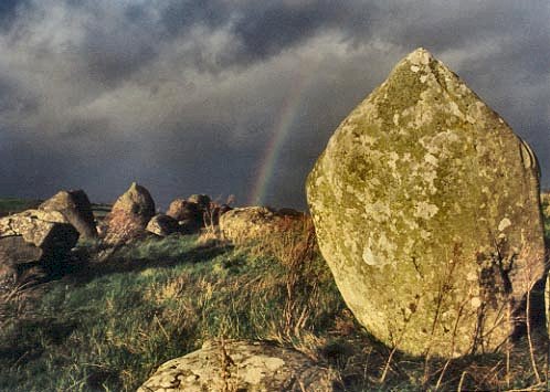
Stone circle 4 km
S of Downpatrick, approached by an old sunken
lane, a very large circle of over 50 stones up to 1.8
metres high (though many smaller) encloses a space about 35
metres across. It was modelled on the circle at Swinside in
Cumbria - which is at exactly the same latitude. In the E half
of the circle is a long low mound which contained large kists
at the E and W ends. This mound obliterated two shortlived cairns
built after the circle was constructed, in what Aubrey Burl
describes as "prehistoric bigotry and vandalism [which] ruined
this magnificent monument."
This might have occurred around the same time as the deliberate
overturning of all the stones at the recently-discovered Sittaford
Tor circle on North Dartmoor in SW England.
~ About 850 metres ENE in the same townland, in a field to the N of the Grangecam road (J 489 406) is a quartzite block about 1.3 metres high, with elliptical solution-pits(?) similar to many at the stone circle, and on stones at circles in county Wicklow. ~ 7 km NNE is the megalithic kist at Slievenagriddle. ~ 7.5 km NW at The Buck's Head in Annadorn (J 429 459) is a collapsed portal-tomb, whose capstone has many small solution pits on the upper surface, two of which appear to have been enlarged.
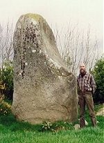
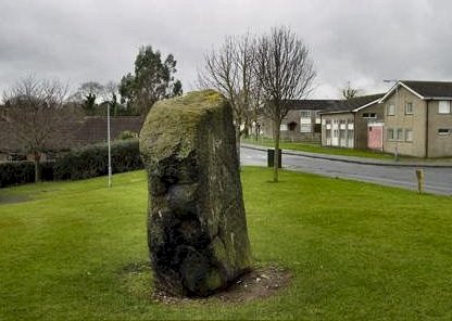
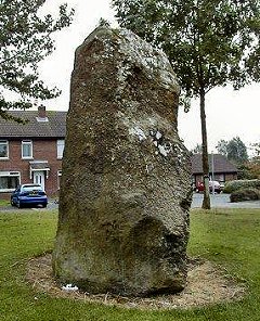
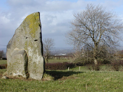
Barnmeen:
Standing-stone click
on the thumbnail for a larger picture Behind a hedge to the S of a by-road, this massive stone is 3.6 metres high and has a distinctive concavity or 'shoulder', presumed artificial, on the N side. This is a feature of other megaliths in the area, such as Tamnaharry and Wateresk, below. ~ 10.5 km NE are the pair of standing-stones at Moneyslane (see under Legananny, below). ~ 5.2 km WSW in Saval More (J 122 312), in a private (disused) burial-ground to the E of a by-road are a pair of standing-stones 2 metres apart and 1.9 metres high. Both are of granite, and the larger is pointed while the smaller is flat-topped (male and female ?), while
200 metres SW, in the field on the other side of the road (J 120 310) is another standing-stone 1.8 metres high, and also of granite. ~ 10.5 km NW of Barnmeen
(J 101 411 on sheet 20) in Greenan, just behind and between
two bungalows, are "The Three Sisters" - an alignment
of three block-like stones aligned NW-SE and barely-visible
in a field-boundary. The south-easterly one has fallen, and
measures over two metres in its entire length. The other two
stand 1.6 and 1.5 metres above ground-level. The taller one
is beautifully squared at the top and on its E face. - 1 km NE of "The Three Sisters" in Drumnahare (J 111 415 on sheet 20) on the NE shore of Lough Brickland and visible from the dual-carriageway is a small, knobbly, leaning standing-stone. In the lake (visible to the right in the photograph below) is a crannóg. ~ 7.3 km SW of Barnmeen
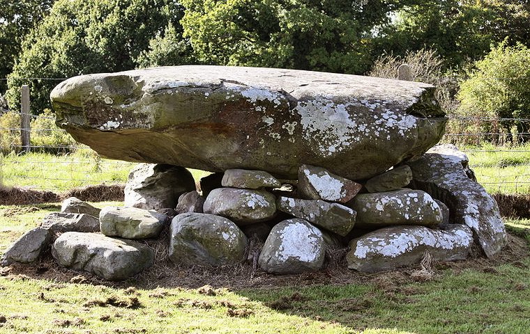
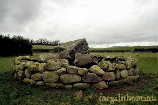
is the phallic monolith at Crobane (see below under Tamnaharry). Drumena:
Stone Fort or Cashel, Souterrain and Kist Overlooking Lough Island Reavy, this stone fort with a wall averaging 2.75 metres high and 3.3 thick, has been somewhat restored.
The present entrance may not be original, nor the present main entrance to the souterrain or stone hiding-place which leads from ruins of buildings which seem to be of recent date - though perhaps built over earlier flimsier ones. The souterrain is 15 metres long, 2.1 metres high, and has a rectangular chamber facing the original narrow entrance which is at the opposite end to the modern widened one. (For another, more complex, souterrain see Ballyhackett under Ballygilbert, county Antrim.)
~ 400 metres SW on a ridge at a height of 200 metres (J 305 336) is a small round cairn (bounded by modern field-walls on 2 sides) with a kist 60 cms deep whose capstone has been slid to one side allowing a view inside. Goward:
Portal-tomb Cloughmore,
or Pat Kearney's Big Stone, is beside a lane running
SE from the Hilltown-Castlewellan road. An enormous 50-tonne
granite capstone has slipped, exposing a chamber closed by a
slender door-slab over 1.5 metres high. As at Tirnony
(Derry) and Ticloy (Antrim) a flanking, free-standing
orthostat suggests a derivation from the court-type of tomb. ~ 1.5 km SSW in the same townland (J 237 297) on the S slope of Goward Hill is the first Irish court-tomb to be excavated in modern times (1932). Previously it had been thought to be a stone circle, because of the impressively semicircular court of eleven stones some 11 metres across. The gallery is 9 metres long, and the first of the three chambers has double walling for better support of the (missing) roof. The entrance to the gallery was sealed by a dyke of cairn material 2 metres wide crossing the forecourt, in the centre of which was a rough pavement of slabs set in a layer of charcoal containing many Neolithic potsherds.
Greengraves:
Portal-tomb Across a field to the
N of a by-road leading S from the dual-carriageway from Belfast
to Newtownards, this small dolmen is quite impressive with its
oversailing roofstone at a significant angle common to many
portal-tombs, supported on two orthostats and another smaller
roofstone. It has a fine half-doorslab. The name "Greengraves"
is particularly interesting, since the "Green" part of it comes
from the Irish for "sun". The name of the tomb, The Kempe
Stone[s], derives from Norse "Kampesten": big stone or prehistoric
tomb. ~ 2 km
WSW of Greengraves, in Ballybeen housing-estate (J 426 731)
is a chunky standing-stone, 2.2 metres high by 1.2 metres wide
and 1.1 metre thick.
~ 7 km SE of Greengraves, in Ballygraffan (J 473 672) is the fine surviving capstone of a portal-tomb surrounded and possibly supported by the stones of a wall in which the tomb was incorporated until recently. Kilfeaghan:
Portal-tomb Off a lane leading N from the Newry-Kilkeel road, this granite dolmen looks like a giant tortoise, with a big capstone 2 metres long and 1 metre thick, and orthostats half buried in field stones and cairn material. An early account states that the cairn (now mostly disappeared) extended for over 7 metres in front of the N-facing chamber, so that there might once have been a façade similar to that of the court-tombs. ~ 5.6 miles E by S, in Dunnaman just to the E of a churchyard behind the hamlet of Massfort are the sizeable remains of a court-tomb with a 4-chambered gallery but no surviving forecourt or cairn. Some of its side-stones are massive, and seem to have been split from a larger boulder.
~ 7.6 km E by S is another granite dolmen at Kilkeel.
Kilkeel: Portal-tomb In a hidden tarred
lane in the fishing-port of Kilkeel, approached through a garage
on the N side of the main street, or via Cromlech Park to the
E of the road to Hilltown, this little dolmen is quaint and
impressive, though incorporated into a hedge and fence. Known
as The Crawtree (=Elder-tree) Stone it is over
2 metres high, with a capstone nearly 2.5 metres long, resembling
the shell of a tortoise (like Kilfeaghan 7.6 km W by
N). Facing south, the low morning and afternoon sun shines on
the underneath of its capstone, making one speculate that its
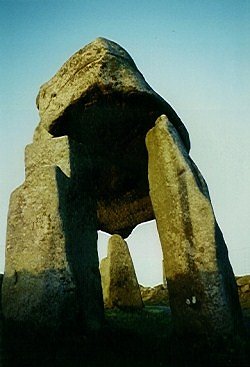
cairn did not reach very high. ~ Just over 6 km NE, in Moneydorragh More (J 355 199) near the road is The Long Stone, a granite monolith 3 metres high. Legananny:
Portal-tomb By the side of a lane
leading from a by-road on the flanks of Slieve Croob, this "tripod-dolmen"
is one of the most striking in Ireland, commanding superb views
of the Mountains of Mourne to the S. The capstone (at the typical
angle) is over 3 metres long supported on fine portal-stones
1.5 metres high, one of which has a distinctive L-shaped bite
in it, significant if not artificial. The early-morning sun
beautifully illuminates the entire underside of the capstone
and tip of the backstone, and, later, parts of both the underside
and top of the capstone are lit. click
for high-resolution pictures
~ 1.9
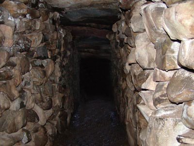
km WNW in Finnis (J 272 442) is a simple souterrain
recently opened to the public and known locally as "Binder's
Cove". (The word cove, sometimes used in local,
unofficial names, is a conflation of the English cave and
the Irish uamh.) The main passage is about 30 metres
long and the two side-passages on the right-hand side are 6
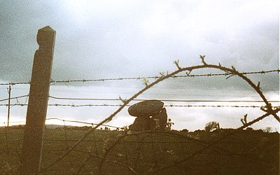
metres long. All are lintel-roofed. ~ Just under 5 km SW at Moneyslane (J 254 399 at the top edge of sheet 29) is a fine pair of standing-stones, visible to the E of the road. One is flat-topped and female, while the other, a little taller at 1.7 metres, is remarkably phallic from the E side, with a mend of cement delineating a scrotum. For many years these stones (in the middle of a field) have been curiously and separately wrapped with barbed wire, still present in 2003. Portavoe:
Standing-stone Because it is crammed between a juniper tree and a suburban stone-clad wall, on the W side of the Donaghadee-Groomsport road opposite a jetty, this veined sandstone pillar, though 2.5 metres high, is not really worth a detour. It was excavated in 1968 and found to be the survivor of a pair half a metre apart. To the N in the same townland are two more stones, both just over a metre high, and one standing below the present high-tide mark. The other is in the little valley of the little Portavo river, on the N side of the stream, some six metres above the high-tide mark, and might be the remains of a portal-tomb. An
excellent history of the townland over the centuries has been
written by Peter Carr. ~ Some 28 km SE, down the same peninsular coast, close to an Anglo-Norman motte, and marked on the wrong side of the road on sheet 21 is another standing-stone close to the shore at Ballyhalbert (J 647 636). It is is a sandstone erratic, two metres high and only 50 metres S of a housing development.
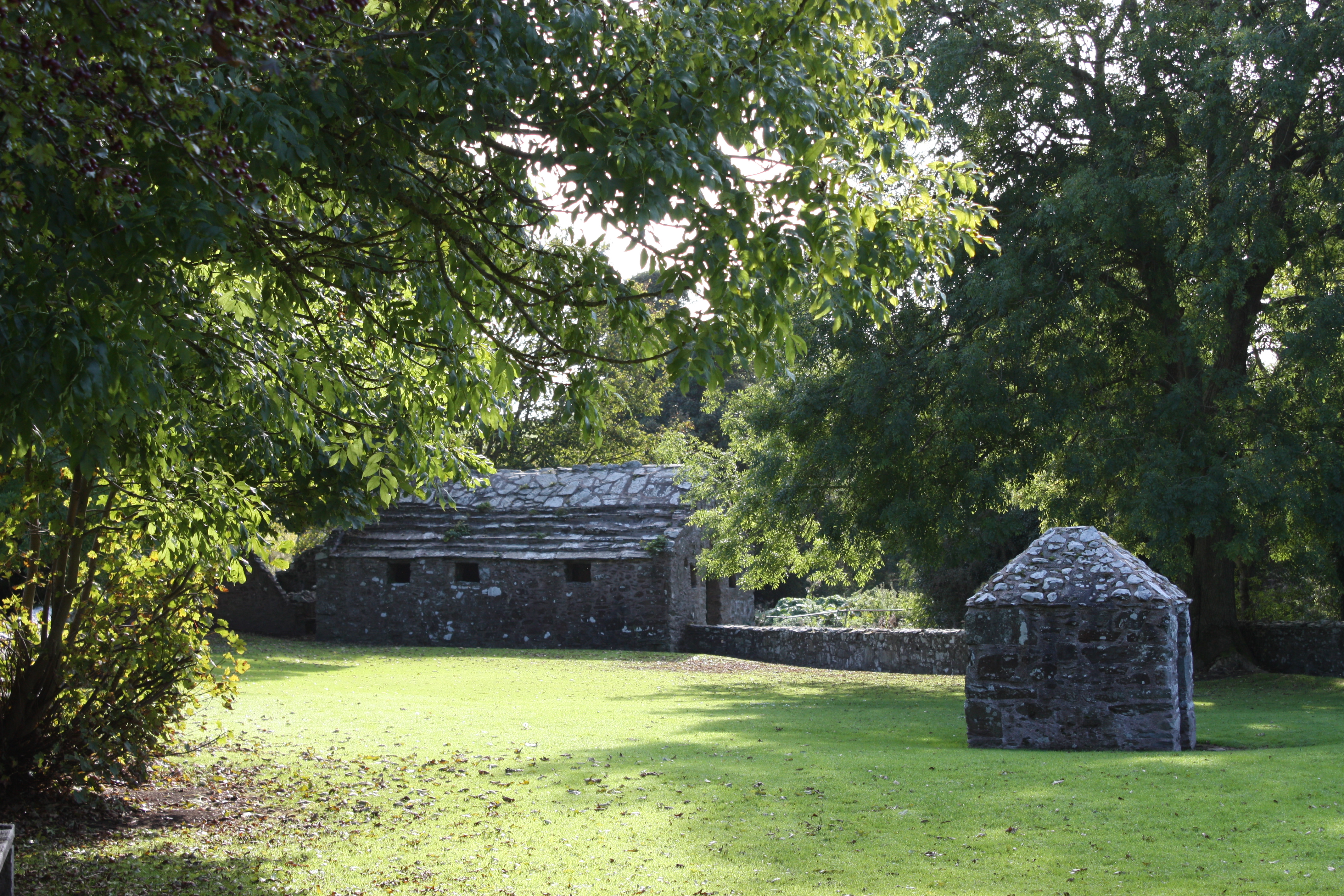
2 km S of Millin Bay is another remarkable (but not megalithic) site: "St Coey's Wells", in Templecowey (J 627 475), which like the better-known stone-housed Struell Wells and mediæval baths just E of Downpatrick, are pools in a single stream (Srúthail is Irish for 'stream'). Each is used for a different complaint: a washing-well (for skin conditions), an eye-well, and a drinking-well. The eye-well has a magic hawthorn beside it, festooned with rags which now, typically and deplorably, include paper tissues. Between the stream and the modern outdoor altar is an ancient Killeen (Irish cillín = little church or little churchyard), rare in the Northeast of Ireland but common in the West and South. These were the burial grounds of the rural Catholic poor in times when Ireland was poorer than, for example, northern Albania. The graves are marked by small and uncarved, un-dressed pieces of shale set upright in the ground. Slievenagriddle:
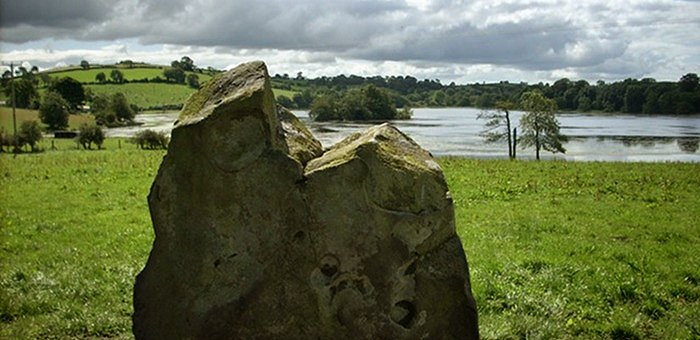
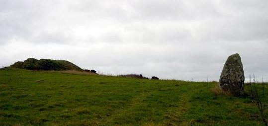
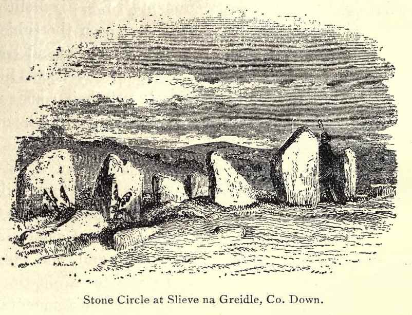
Megalithic tomb This
is a rare of example of an intact, unexamined hilltop tomb of
which only the large capstone can be seen. It is not a collapsed
portal-tomb as suggested by the published Archæological
Survey of 1966, and its commanding position above a lake, offering
vistas across the Irish Sea to the Isle of Man and Cumbria,
and westwards towards the Mountains of Mourne suggests a hilltop
megalithic kist typical to Leinster rather than Ulster, with
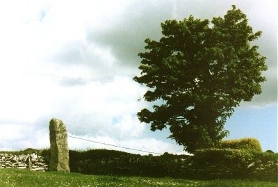
an untypically huge roofing-slab. ~ 1.3 km NE in Carrownacaw (J 544 464) is "The Long Stone" a tall thin standing-stone of schist, 3.3 metres tall - and the only Irish menhir to be supported by a hawser wrapped around a tree. This is reached by a road which passes picturesque Loughmoney "Dolmen": just two sidestones and a roofstone of a destroyed court-tomb in a field. click
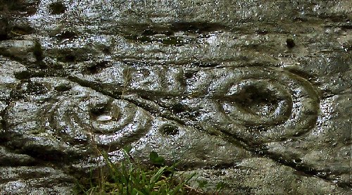
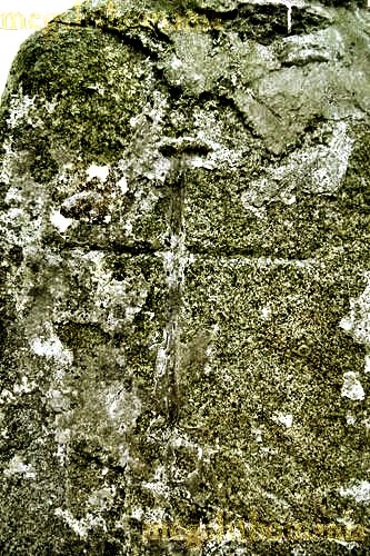
for high-resolution pictures ~ 6.3 km NE in Audleystown (J 561 505), close to Strangford Lough, is a well-preserved, small double-court tomb built of low stones and comprising shallow forecourts, two galleries of four chambers each, a cairn some 27 metres long, and a kerb made of orthostats instead of dry-stone walling. ~ 4.6 km ENE, in the front garden of 109 Ballyculter Road in Ballyculter Upper, 40 metres from the road-junction, is part of a natural rock-outcrop decorated with two worn sets of concentric circles - best seen when wet. One of the sets has a remarkable 10 rings, while the other has 6. This is an example of the overlap of passage-tomb art with Bronze Age rock-scribings or petroglyphs. ~ Just under 5 km WSW of the Ballyculter rings, 1 km NW of Slievenagriddle at Ballystokes (J 5263 4577), in a field a few metres to the NW of St Patrick's Way, is a small group of typical (but very worn) Bronze Age petroglyphs featuring cupmarks and penannular rings. The Archæological Record states: 'This outcropping slab of shale is known to bear cup & ring marks, but is now largely covered with loose soil & vegetation & the ornament is barely visible. Nearby is the find spot of axes & a possible kist grave'. In fact, it is fairly clear from vegetation, but water should be brought for pouring over the rock to make the petroglyphs visible. From the site the sun sets behind Slieve Croob at the summer equinox, and behind the Mourne Mountains at the winter equinox. ~ Near the other end (and immediately E) of the Ballyculter Road, below Slievenagriddle, in a dense thicket in Ballyalton (J 532 448) is a court-tomb hardly worth visiting because of the thorny impenetrability of access, but which features in the literature because it was excavated in 1933 and gave its name to a kind of Neolithic pottery first found there. Six stones of a court remain, two of which are portals leading to a two-chambered gallery, many of whose stones survive. None is more than a metre high. Click here for an early drawing - transposed to the top of Slievenagriddle! ~ Just over 10 km ENE of Slievenagriddle (by expensive ferry across the strait from Strangford) is Millin Bay (see under Portavoe). ~ 4.7 km W by S of Slievenagriddle, at the NW edge of Downpatrick, approached via the cathedral and Down County Museum, is The Mound of Down, a fine Iron Age defensive earthwork in the middle of which a Norman motte-and-bailey was built. It has recently been damaged by 'conservation' work. The cathedral stands in the middle of another defensive site or Dún, which gave its name to the citadel before the spurious 'Patrick' was added by a Norman war-lord in the 13th century. Signs similarly motivated proclaim Downpatrick as "Ancient City of Down" when they really mean "Ancient Citadel of Down".
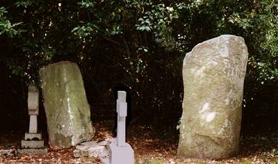
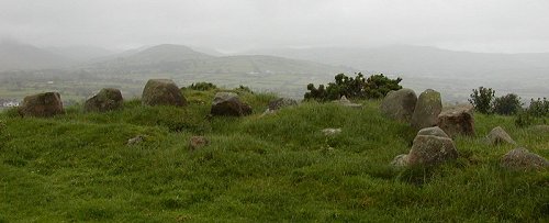
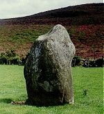
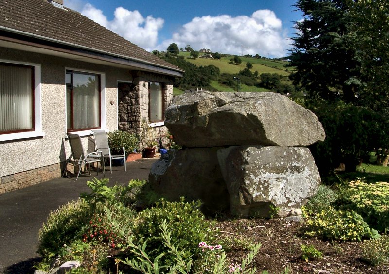
Tamnaharry:
Standing-stone click
on the thumbnail for more pictures Just S of a rocky track leading E off the Burren-Mayobridge road, commanding fine views to the Carlingford Mountains and Slieve Gullion, this Cloghadda is a fine granite standing-stone some 2.8 metres high with a concave and probably artificial 'shoulder' on the N side, to be compared with the stone at Barnmeen (8.5 km NNE). Beside it are traces of a prehistoric enclosure. ~ 2.2 km NNE (J 161 266) in the townland of Mayo, is "The Long Stone", an impressive and sculptural granite monolith 3 metres high. ~ 1.2 km NE of Tamnaharry in the same townland of Mayo (J 164 252) is a less impressive but more accessible standing-stone, some 1.6 metres high and commanding extensive views. The N side of it is sheer and rectangular, suggesting that it might be the remnant of a portal-tomb, as indeed, many standing-stones of similar height could be. ~ Just under 5 km NW of Tamnaharry, in Crobane (J 121 279) immediately W of a by-road is a fine phallic menhir offering extensive views to the W. ~ 1.4 km SW in Burren (J 134 226) are the remains of a court-tomb - the only one to form part of a bungalow rockery! - comprising a granite roofstone resting on 2 parallel slabs of gritstone. The former cottage next-door is advertised as the birthplace of the great Irish Socialist, Jim Larkin. ~ 2.2 km W by N in Milltown (J 133 247), immediately W of a by-road are the remains of a double-court tomb whose cairn survives to a height of 2.5 metres, and one of whose forecourts and possibly 4 chambers of one of the two galleries can be distinguished from the cairn material and dumped field stones. ~ Between
2 and 3 km NNW in different townlands are cashels and standing-stones
marked on the map. One of the cashels (in Edenmore, J
145 267) is better-preserved than most in Northern Ireland,
with walls approaching 4 metres high in places and constructed
of massive stones, but, typically, is littered with refuse and
junked machinery. ~ 4.5 km NE in Mullaghmore (J 193 272 - not marked on Sheet 29), immediately E of a lane leading to house N� 46, is what Aubrey Burl considers to be one of the few "four-poster" stone circles in Ireland, measuring 2.7 by 2.7 metres diagonally between the low stones, the tallest of which has broken, with more than half of it lying nearby. A large pot and two cremations were found within it. Beside the circle is a saucer-shaped depression: a Ring Barrow which was constructed over a pit which contained Late Bronze Age potsherds, a very small blue glass bead & the cremated bones of at least 4 individuals. The site is known locally as "Murphy's Fort".
Wateresk: Portal-tomb In a field to the W of a by-road running parallel with the new Dundrum-Newcastle road, this sculptural tomb looks very different from different angles. Known also as The Slidderyford Dolmen its granite capstone is 3 metres long by 1 thick, resting on three support-stones, the tallest being 1.8 metres high. The capstone fits very neatly into a concavity in the smaller portal-stone, echoing other megaliths in South Down. The chamber is no longer definable. ~ 400 metres SW to the E of a by-road, in Ballyloughlin, are the remains of another megalithic tomb with a portal-stone 2.7 metres high and carved with the name of Jeremiah Atkins. There is another stone just under half as high at the other side of the hedge and bank. |
 click for another photo
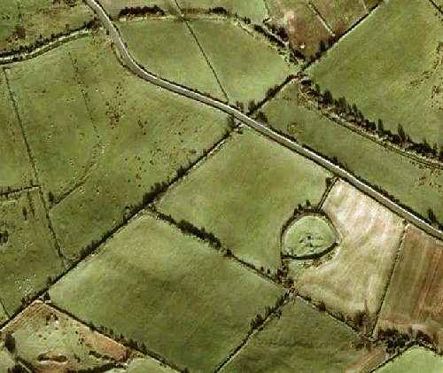
 click
for a larger picture
click
for a larger picture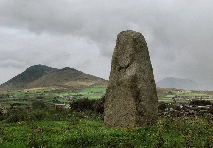
