
county list
![]()
|
Turn smartphone to horizontal
view. SELECTED SITES IN COUNTY WICKLOW Place-names in italics refer to listed entries. Convert Irish Grid references to Latitude/Longitude |
|
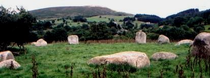
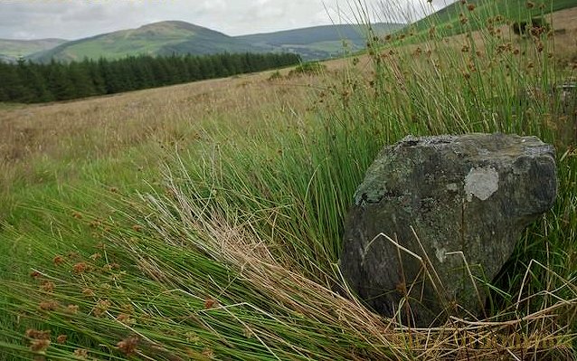
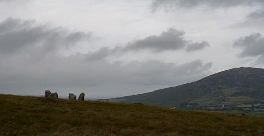
Athgreany: Stone Circle N 930 032 Sheet 56 2.5 km S of Hollywood and visible 175 metres E of the road to Baltinglass, this is probably the best-known of the Middle Period "Leinster Type" of stone circle, which derive from the British type of circle at Ballynoe, county Down. Known as The Piper's Stones because of the single outlier which is, according to legend, the petrified piper with the petrified ring-dancers. The circle of fourteen stones - some of which are boulders, and others which are pillars up to 1.8 metres high - is about 28 metres in diameter. click
for more ~ 600 metres SE of the stone circle (N 935 028) is a squat standing-stone just one metre high, which, though not impressive in itself, offers a fine view over county Kildare to the W - as well as to The Piper's Stones in the valley beneath, towards which its long axis points. ~ 2 km W in Crehelp (N 919 033 on sheet 55) is a grooved standing-stone some 2 metres high, of the Carlow-Wicklow-Kildare group (see Broughillstown, below), perforated by a curious rectangular hole. ~ 2.6 km SE, on top of Slieve Gad or Church Mountain (N 948 013) is a large ruined cairn some 25 metres in diameter, which once contained a passage-tomb, then an early Christian church, of which little remains. The chief reward of the steep 350-metre climb from the road is the panoramic view.
~ 9.6 km SSE are somewhat-chaotic, Leinster-type stone circles at Castleruddery (S 925 937), 8 km NE of Baltinglass village. ~ A little under 9 km SE (4.5 km ENE of Castleruddery) are three bullaun stones in Kelshamore. ~ 6.8 km E of Baltinglass village (N 938 892) is another multiple-stone circle at Boleycarrigeen, fairly well preserved and enclosed in a circular earthen embankment. Eleven out of the original seventeen or eighteen stones survive. The circle is surrounded by conifers. ~ About 1 km NE of Boleycarrigeen, unmarked on sheet 62 in Keadeen (S 944 897) is another stone circle, some 5 metres in diameter and with traces of a bank on the N side, identified by Ian Thompson in 2004. On a site commanding fine views, 7 of a probable 13 stones still stand, including two radially-positioned entrance stones.
A projected line through these entrance stones from the centre of the circle to the SE leads to a standing stone standing 1.5 metres high 100 metres or so away at S 945 896. From this spot the Boleycarrigeen circle would be visible across the valley - were it not surrounded by trees.
Ballyhad:
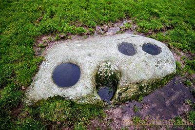
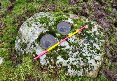
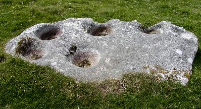
Bullaun stone Just 3.6 km from Rathdrum, this remote and splendidly-located bullaun stone is on the end of a north-westerly pointing spur with an amphitheatrical panorama. Earth-fast and measuring just one metre long and 60 cms wide, it has no known monastic association and is probably pre-Christian. It has two large bullauns in its upper surface about 25-30 cms in diameter, one of which is shallow and the other as deep as it is wide.
~ More bullauns can be seen at Baltynanima, Glendalough and Roundwood. See also Kilbeg under Seefin, below. ~ 9.6 km S by W and
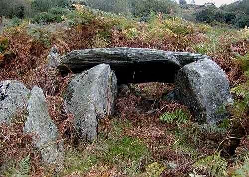
less of a walk in Mongnacool Lower (T 163 817 on Sheet
62), hidden in bracken, is a small and neat wedge-tomb, standing
on a rectangular platform of stones, which is all that remains
of the cairn. On either side of the gallery are two halves of
a split boulder. Leaning against these, across the east-west
line of the gallery is a displaced roofstone. On the north side
there are hints of double walling.
Baltinglass:
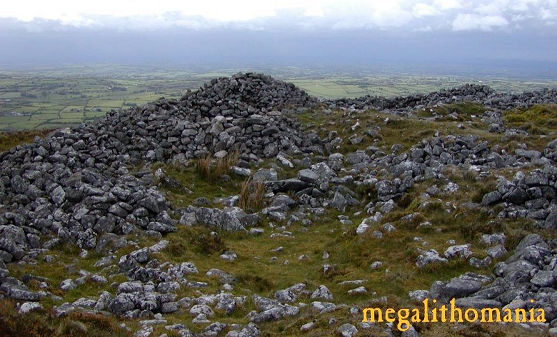
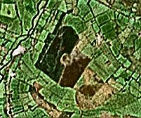
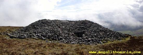
Passage-tombs click
on the aerial photograph for detailed pictures On the
top of Baltinglass Hill, close to Baltinglass village, approached
from a narrow by-road to the NE of the hill, this large complex
has a massive surrounding wall - which is modern. A large cairn
some 27 metres in diameter, robbed for wall-building, still
retains most of its internal features. The site comprises remains
of 3 small passage-tombs built at different times and partly-overlying
each other, plus two single-chambered tombs. In the circular
chamber of the latest passage-tomb (III) is a large stone basin
decorated with a double-armed cross within a cartouche. Some
of the roofstones of its narrow passage survive. There is a
beehive-shaped chamber which the excavator considered contemporary
with Tomb I (largely overlaid by Tomb II, a central chamber
surrounded by 5 side-chambers, whose gallery is overlaid by
Tomb III), and a ruined kist which is at least as recent as
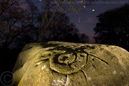
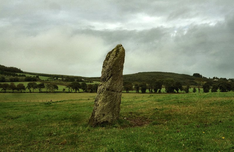
Tomb III. ~ 4.8 km S by E of Baltinglass village, in Broughillstown, to the N of Broughillstown House and 80 metres E of the main road to Tullow, is a grooved standing-stone 1.5 metres high, which, like that at Ardristan Carlow, belongs to the Carlow-Wicklow-Kildare group. ~ 7.2 km ESE of Baltinglass village, in front of Humewood Castle (S 938 857, sheet 62), is a prostrate stone 1.5 metres long, decorated with cup-and-ring designs, which was dug out of the ground when an artificial lake was being created.
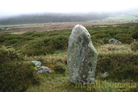
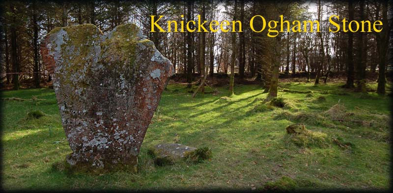
~ 9 km NE of Baltinglass village in Kelshamore (S 957 948) are three boulders with bullauns, the largest being an earth-fast block over a metre long with three large bullauns in a row. ~ Just under 11 km NE of Baltinglass village, easily accessible in a forest clearing in Knickeen (S 983 949, marked on sheet 56) is a fine standing-stone bearing a weathered ogam inscription.
~ 6.8 km E of Baltinglass village is Boleycarrigeen stone circle. ~ 7.5 km NE of Baltinglass village is Castleruddery stone circle. ~ 15.5 km NNE of Baltinglass village is Athgreany stone circle. Baltynanima:
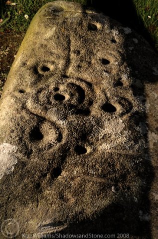
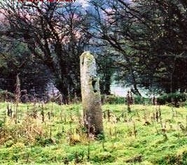
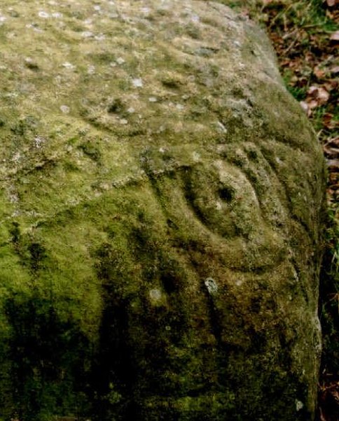
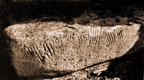
Petroglyphic boulder click
on the thumbnail for a larger picture When I first
saw this stone - in the 1970s, it was by
the far hedge of a field to the S of the by-road from Togher
(Roundwood) to Lough Dan (not marked on the map), dug up from
the field and placed among other boulders along the hedge. Later
removed by the landowner to his house in Roundwood, it is a
fine stone 1.2 metres long and about 38 cms high, with 14 cup-marks
on its upper surface, ranging from 10 to 11.3 cms in diameter
and up to 7.6 cms deep. One is surrounded by a ring, and a pair
has a partial ring. There are also wide, almost parallel, grooves.
Two other similar stones were reported to have been found in
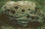
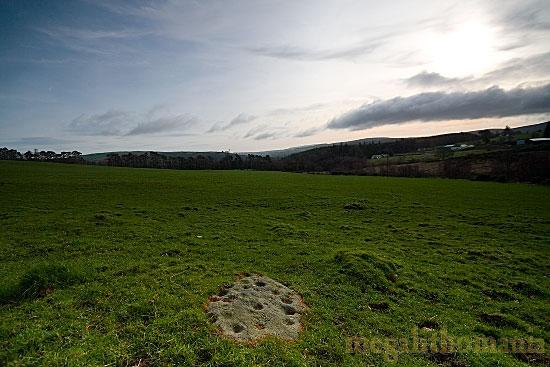
adjacent fields. ~ 2 km SW of Roundwood in Baltynanima townland, and marked Bullaun Stone on the map at O 176 018, is a fine rock outcrop in the centre of a field. "Well worth the hike 600 metres from the nearest road either across bog land or through thick woods", it has two good bullauns over 20 cms in diameter. For more bullaun stones see Roundwood and Glendalough, and Kilbeg under Seefin, below. ~ 2.8 km WSW in Oldbridge (O 153 016) is a fine petroglyphic boulder nearly 2 metres long long and 1 metre at its widest. It has 5 cups with single rings, 6 cups on their own, 1 cup with 2 concentric rings and 1 more with 3 concentric rings. These are now all weathering and were much bolder when the stone (quickily dubbed "The Witch's Stone") was unearthed. It is very possible that it came from a tomb.
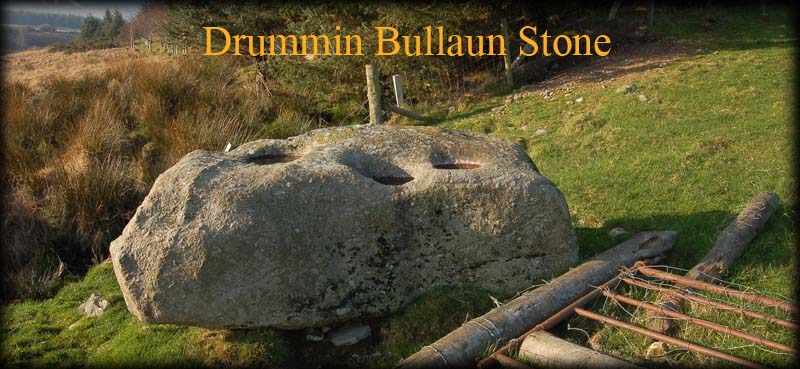
~ 3 km SW in Drummin is another bullaun stone (O 156 001) - a large boulder over 2 metres long and 1 metre high. It has three large bullauns, two of which are over 30 cms in diameter.
The largest, at the E end of the panel, has two rings and 'spider-legs' around it.
~ 4.5 km SW (and 1.7 km SW of Drummin bullaun stone in the same townland, T 145 988) are "The Gossan Stones", a male/female pair only 1 metre high. unusually aligned North-South, with the female being to the N. They are on a saddle between two peaks, due W of the cleft of The Devil's Glen.
Castletimon:
Standing-stone A somewhat-jagged (or damaged ?) stone, over 2 metres high, is easy to see on a slight rise N of a by-road, in the grounds of the modern Castletimon House (stud-farm). In the same townland, some 400 metres South and now recumbent in a roadside niche at T 298 855 is "The Giant's Stone", an ogamised pillar-stone. The inscription reads NETA CARI NETA LAGI. ~ 200 metres S of the ogam stone, in Brittas, is a ruined and formerly-overgrown portal tomb. Glendalough: Bullaun-stones T 123 969 Sheet 56 At the
far end of the riverside car-park close to the gate-house is
a field-gate, with a bullaun stone and a crude cross-base next
to it.
At the far end of the same field is another rather unusual bullaun stone whose upper surface has been squared-off. The single bullaun is set into a raised, level, rectangular area, and is quite small at about 20 cm in diameter. The early Christian monuments (especially The Nuns' Church)at Glendalough are outside the scope of this Gazetteer, but, of course, are well worth visiting. Some forty bullauns have been reported in the Glendalough area. ~ 7.4
km NE are more bullaun stones at Roundwood Graveyard. ~ Some 8 km SSW of Glendalough, at Fananierin (T 103 890) is a cupmarked slab a little over one metre long and 50 cm wide. There is a parking-place nearby on the scenic road from Laragh into the mountains.
A short distance SW is a curious standing-stone some 70 cms high, partly hidden by a clump of reeds.
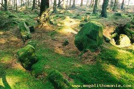
A short distance SW is a chunky standing-stone some 70 cms high partly hidden by a clump of reeds. Situated now in a felled (2004) conifer plantation this once-mossy site is not easy to find - but worth the effort. The kerb is some 7 metres in diameter consisting of small, dull, dark grey granite stones, but on front of the entrance, facing W, are two large blocks of granite with considerable quartzite content. On the kerb facing S is an unusually shaped stone of the same material. Several others are mingled in with the débris and these might also have indicated significant directions. Part of the undecorated chamber survives under an enormous tree.
Moylisha:
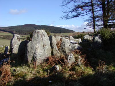
Wedge-tomb 9.5 km SE of Tullow and 2.5 km S of Aghowle Romanesque church, approached up a laneway and then across two fields beside a clump of trees, this monument is unusual in that its main chamber widens towards the back, together with the outer walling, so that the wedge shape is reversed. The usual portico or antechamber is demarcated by a septal slab. This tomb resembles many in the North of the island.
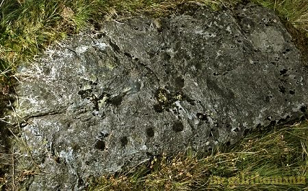
~ 2.5 km N is Aghowle Romanesque church, 100 metres SE of which, in the middle of a field (S 933 693) is a boulder with four bullauns, three of them intact and each around 30 cms in diameter.
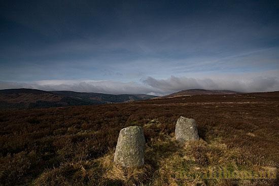
Parkmore: Stone pair T 212 961 Sheet 56 Close to the road is a pair (male and female) of stones one metre high and two metres apart, standing on a little ridge - suggesting that there might originally have been more. A nearby cairn has completely disappeared. Parknasilloge:
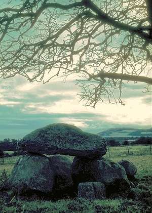
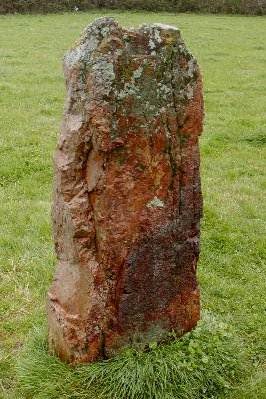
Megalithic tomb 1.2 km W by N of Enniskerry and 1.6 km S of Killegar Church (with interesting 12th century cross-slabs), close to a lane running N from the road to Glencree, this unmarked tomb is picturesquely sited under a small tree. It may be a large megalithic kist, with a capstone 1.6 metres long supported by 2 long slabs. The two end slabs have been displaced. The site has recently become a stone-dump. ~ 5.6 km SW in Kilmurry (O 227 139) is a fine standing-stone somewhat pathetically situated next to a rough football-pitch and beneath power transmission-lines. Visible through a roadside gate, it is a chunky block of beautiful red stone some 1.6 metres high, in the middle of a field, best viewed (as below) when wet.
Rathgall:
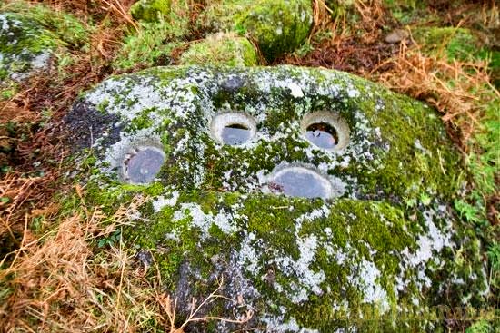
Hill-fort For some reason I did not include 'The Ring of the Rath' in this guide, although I visited it some time in the 1970s. I have no notes on it, so I will, apologetically, direct readers to Voices of the Dawn for an excellent description and good photographs of the site. Roundwood: Bullauns O 184 014 Sheet 56 Three bullaun-stones are situated in the old graveyard in the townland of Ballynacorbeg. One is just inside the west wall of the graveyard, and is reached by walking along the path from the gate, past the church. The stone, at the bottom of some steps, has two depressions, one of which is large and deep, the other smaller and shallower.
The
second is an octagonal, earthfast boulder just outside the W
wall. It has two very large bullauns, the larger being 40 cms
across. ~ 2.7 km NE at Knocktemple (O 206 029) is another bullaun stone, sitting on top of a dome-like knoll which is bordered on the S by a ravine created by a stream that runs down to the reservoir to the W. On the edge of the ravine is the ruined church of Knocktemple, and 35 metres to the N of it is the bullaun stone, with a sinle depression some 35 cms in diameter. Uncharacteristically, the upper surface slopes down.
More bullauns can be seen at Baltynanima and Glendalough. See also Kilbeg under Seefin, below. ~ 4.1 km W, to the W of Lough Dan in Carrigeenduff, is a large stone with petroglyphs on it - quite easy to find when you know where it is: behind the mailbox for Bracken House at O 150 031. Seefin:
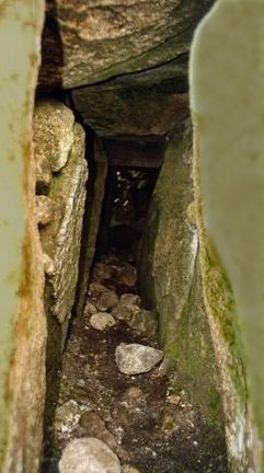
Passage-tomb On the summit of Seefin hill, best approached from the Kilbride (South) side of the hill, through about 200 rising metres of heather, the kerb-surrounded cairn of this massive tomb is 24 metres across and 3 metres high.
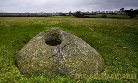
From the N side a narrow passage, 7 metres long, leads through an imposing entrance into the now-roofless chamber. This is shaped like a 'Cross of Lorraine' with five recesses, two of which are marked by sills. One of the surviving granite corbels near the entrance has a faint decoration of five lines like a hand or ship. Two of the orthostats of the right-hand side of the passage are faintly decorated with concentric lozenges. Other stones in the passage had a thin layer of quartz on them. An equal-armed cross reported to have been on one of the roof-stones was probably Early Christian. The tomb has probably been open for two millennia, and is in a very parlous state due to modern damage and official neglect. For more information click here. ~ 9.5 km SW, in a sloping, boulder-strewn field overlooking Poulaphuca Reservoir (O 022 102) in Kilbeg, is a fine bullaun stone some two metres long by one metre wide and 20 cms high. Six large depressions measure from 20-25 cms across and up to 10 cms deep.
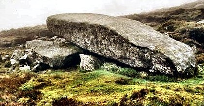
~ Just under 11 km SE, on the N side of Djouce Mountain (O 173 105) is "The Coffin Stone", a five-metre long capstone of a collapsed dolmen. This monument is worth visiting only in very good weather.
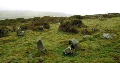
Toor:
Stone Circles On a little raised platform, three "Piper's Stones" (each a little over 1 metre high) remain of what was probably a five-stone circle. If so, they are the two portal stones and the axial pointing SW. The axial stone has a deep notch in the top, which, with its tapered sides give it a heart-shaped profile. 200 metres N is a circular feature 10 metres in diameter which is either a henge or a hut circle. The raised bank is just under 1 metre high, and there are two stones set in the northern part of the bank. A low spot on the eastern side marks a possible entrance.
~ 200 metres S (N 960 021) is another stone circle: The tops of four of the stones stand about 1 metre above the blanket-bog. The 1.5 metre-long axial stone is flush with the surface. The central axis of the circle is, uinusually, E-W, with the axial stone to the east. Lying nearby are remains of at least two more stone circles and several stone rows or possibly even avenues. ~ 9.2 km SSW is Castleruddery stone circle (see above under Athgreany). ~ 6.1 km NNW are the
many more "Piper's Stones" at Broadleas, county
Kildare (see under Punchestown). |