
county list
![]()
|
Turn smartphone to horizontal
view. SELECTED SITES IN COUNTY CORK Place-names in italics refer to listed entries. Convert Irish Grid references to Latitude/Longitude |
|
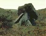
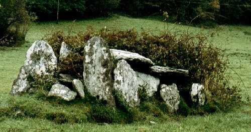
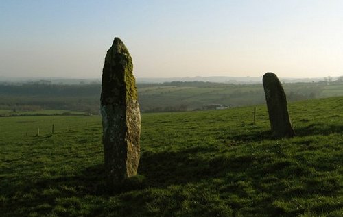
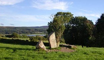
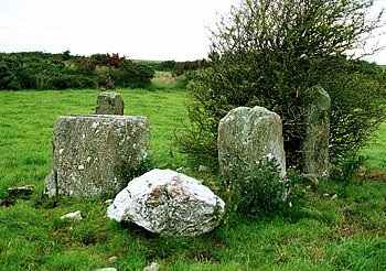
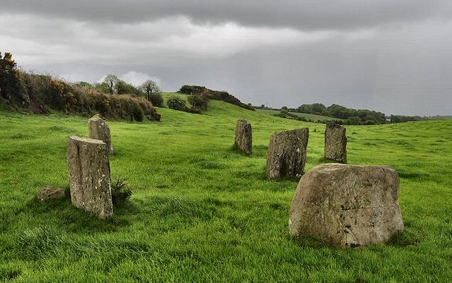
Ahaglaslin:
Portal-tomb click
on the thumbnail for a larger picture
Conspicuously sited
across a little valley E of the Clonakilty-Rosscarbery road
on a ledge of the hillside 2.4 km E of Rosscarbery, and approachable
through a farm to the SW of a by-road leading SW off the Rosscarbery-Clonakilty
road to the NE of the tomb. ~ A little over 850 metres to the N is Bohonagh axial-stone circle. Altar: see under Arderawinny:
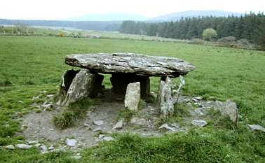
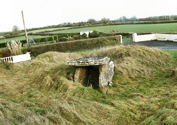
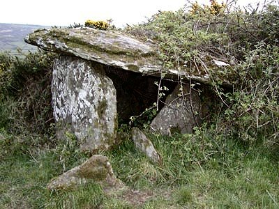
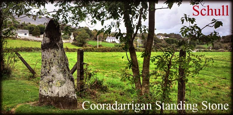
Portal-tomb click
on the thumbnail for larger pictures This picturesque tomb
is 4 km WSW of Skull and about 90 metres N of the road from
Skull to Toormore Bay. in a little hollow, facing into a low
cliff. ~ 1.6 km WSW and 20 metres to the W of the same road, where it meets Toormore Bay, in Altar (V 858 303) is a Wedge-tomb one of whose two capstones has slipped and is now leaning against the front (W) end of the tomb - which points directly towards Mizen Head. It is 2.4 by 2.2 metres with a square piece (? intentionally) knocked off. The other capstone is 2.7 by 2.1 metres. Some of the low orthostats and nearly all of the cairn are missing. Excavations in 1989 showed that the tomb had continuous activity surrounding it from around 2000 BCE to 1400 AD! Somewhat sterilely furnished with its own car-park and information board, the structure has undergone some renovation, but the concrete that now holds up the walls is well hidden. ~ 1.1 km NNW in Toormore, immediately S of the R.951 (V 855 308) is another ruined wedge-tomb of similar design, excavated in 1990, whose single roofstone rests on rather rickety walls. No traces of a covering cairn were found. Five separate 'depositional events' occurred between 1800 and 1600 BCE, soon after the construction of the monument. The O.S. map shows it in the wrong place: it is actually in the garden of the pub to the east of the road junction. ~ 3.5 km NW in Dunmanus (V 854 335), just 50 metres from the road - across a salt-marsh, is a turtle-like boulder-burial. The area around and beneath it has been excavated out and the four stones supporting the top can be clearly seen. This little tomb seems to have been erected to pay some form of homage to the only landmark in the area, the low, but dominating Dunmanus West Hill. ~ 7 km NE in Rathcoole (V 940 333) is an overgrown male/female pair of stones standing in their own little field. They are aligned north-south, with the male (more pointed and slightly taller) stone at the north around 1.5 metres high. ~ 6 km ENE in Skull (or Schull) (V 934 318) is a standing-stone some 1.7 metres tall, on the driveway to The Standing Stone Gallery & Exotic Plant Centre. Click for a photo by Jim Dempsey. ~ 10 km
NNE on open moorland in Dunbeacon (V 927 393) is a circle
of 6 tall slabs still standing (at odd angles) and 5 prostrate,
including one at the centre. As at Bohonagh and Drombeg,
the sea is visible through a fold in the hills to the W of this
magical site ~ 17.7 km NE are the petroglyphs at Ballybane. Ardgroom
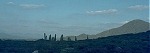
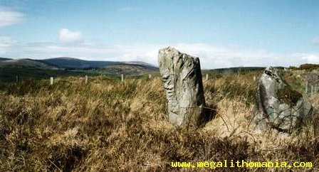
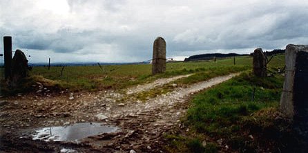
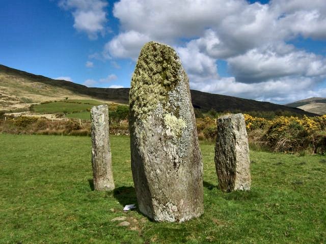
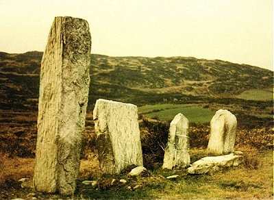
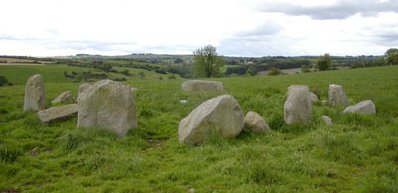
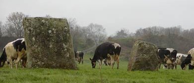
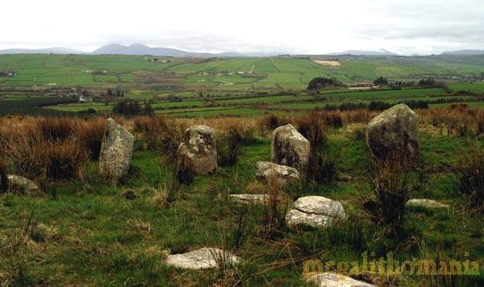
Outward: Stone Circle click
on the thumbnail for larger pictures Commanding a fine view from its exposed position over Bantry Bay 7.2 km WSW of Lauragh Bridge and about 500 metres SSE of the R 571 road, approachable by farm-lane and across bogland, this fine axial-stone circle has stones similar to the pillar-like slabs of the smaller circle at Drombohilly (Kerry), 9.6 km NE. In this circle also 9 stones survive, with some unfortunately missing: one can be seen in a field-fence some distance to the N. They range from l30 cm to almost 2 metres in height. Outside the circle, to the E, is an associated standing stone. The axial stone is, unusually, set with its long axis vertical. ~1.6 km NE is a small (bushy) stone circle at Glashaninnaun (V 719 565) comprising four massive stones two metres high by two metres broad enclosing a space only 4 metres in diameter. ~ 3.2
km W is the tall Ogham-inscribed
standing ~ 9.8 km SSW is another fine circle at Derreenataggart West. ~ Less than 4.5 km E is Shronebirrane stone circle, Kerry. ~ Less than 4.5 km NE is a 5-stone circle at Cashelkeelty (V 748 573). Ballybane:
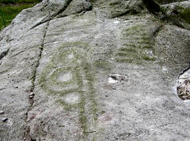
Petroglyphs 9.6 km SE of Bantry and l.6 km SSW of Ballybane House, immediately to W of a by-road on a sharp bend, a large area of horizontal rock surface (not pitted like most of the surrounding surfaces) is decorated with circles and ovals up to 60 cm in diameter, at least one cup-mark and several long straight lines, some of which are parallel. The grooves are unusually wide. ~ The map indicates another group a couple of hundred metres NNW. ~ 17.7 km SW is Arderawinny portal-tomb. ~ 17.5 km SE are Gurranes alignment and Rathdrum fort. Ballyvourney:
Monastic Site, Cross-pillar, etc. This site, 13.6 km
WNW of Macroom, beside a by-road leading S from the N 22 road
between Ballyvourney and Ballymakeery, may be of extreme antiquity.
'St Gobnait's House' or 'St Gobnait's Kitchen' is a circular
hut (partly restored) with an internal diameter of 6 metres.
It was occupied in the Early Christian period by workers in
bronze and iron-smelters. In the graveyard across the road is
"St Gobnait's Grave": a small mound with 3 bullaun stones and
the abandoned crutches and offerings of hopeful pilgrims. Ballyvourney
is the scene of a 'pattern' still performed, and St Gobnait,
a virgin whose emblem is the fertility symbol of the bee, is
credited with the cure of the sick. (A legend connected with
St Gobnait has given the name to the townland of Lackavihoonig:
the flagstone of the thief. The saint fastened the thief and
the cow and calf he stole on to the flagstone on which they
were standing at the fateful meeting. The stone has the imprints
of feet and hooves upon it.) ~ About 1.2 km ESE in a glade in Shanagloon townland are "St Abbán's Grave" (a small cairn), a bullaun stone, and three Ogam stones. A fourth has been removed. The others have been deliberately chipped. ~ At the other side of the main road, in the middle of a large field 800 metres down a by-road (first turn on left past Ballymakeery if going in the direction of Macroom) is "St Gobnait's Stone", found at the site of a dry Holy Well nearby. It is a fine cross-pillar some 90 cm above ground, bearing on each face a cross-pattée of arcs inscribed in a double circle. On one face this is surmounted by a small crozier-carrying figure with parted hair, resembling a portrait in the Book of Durrow. ~ 2.4 km NNW of Ballyvourney, E. of a lane leading from the main road towards Lough Carrignafurark, in Slievereagh, are 2 large, pointed stones 3.3 metres and 1.2 metres high, whose parallel perpendicular faces are only 70 cm apart. Behind them is a low slab, apparently for support. Two stumps lie on either side of the stones, making the monument appear like the remains of a tomb. ~ 13
km NNW is another ritual site at Shrone Beg (county Kerry).
Beenalaght:
Stone-row This is the best-known alignment in the area, 13.6 km SW of Mallow, on a hill to the W of the Mallow-Coachford road about 1.6 km SW of Bweeng. Known as 'An Seisear' (The Six), five stones from 1.8 metres to 3 metres high are standing, while a sixth is prostrate. The area is rich in prehistoric remains, especially Standing-stones. ~ A short distance NW and close to Bweeng in Glandine (W 482 889) is a pair of stones sited in a field beside a deep valley overlooked by the strange 'Monkeys Bridge'. The taller, pointed stone is 3.3 metres and the smaller, more rounded one is 2 metres high. ~ 1.6 km S by W is Gowlane North Stone Circle. ~ 3.6 km NNW are nother alignments in Garrane. Bohonagh:
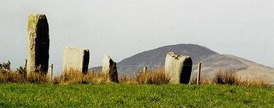
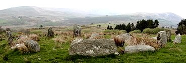
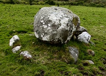
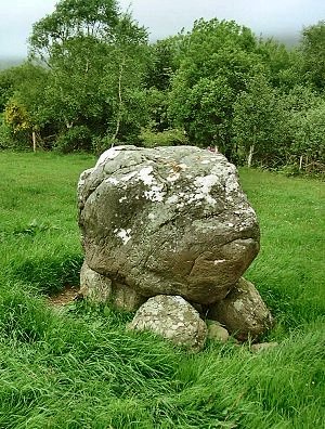
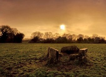
Stone Circle and Boulder-burial Situated 2.4 km E by N of Ross Carbery, to the NW of the road from Ross Carbery to Clonakilty, halfway between it and the by-road leading to Quaker's Crossroads, four out of the original 13 large stones of this impressive circle are missing, and 3 were re-erected after excavation. The 2 portal stones are 2.4 metres high and are set radially. The axis from these to the large axial-stone on the W side points to sunset at the equinoxes. ~ 20
metres E of the circle is a boulder-burial,
resembling a low, rough, diminutive dolmen, whose large capstone
has seven or more small cup-marks on its upper surface. Two
of the three small supporting stones are of quartz;
a fourth has been uprooted. A loose slab nearby also bears cup-marks.
The complex, which included a rectangular wooden house (excavated)
was revealed to be of Bronze Age date, as might be expected.
~ 800 metres SW and 1.5 km) E of Rosscarbery, a short distance W of a by-road in Burgatia (W 303 355), is another boulder-burial, comprising a large boulder resting on the inner edges of 2 flat-topped blocks, one of which is a quartz conglomerate. ~ 800 metres S of Bohonagh is Ahaglaslin portal-tomb. ~ Other nearby stone circles are at Knocks, Drombeg and Reanascreena South. Cabragh:
Stone-rows and circle This group of monuments
is 10 km due S of Millstreet and 9.6 km NW of Macroom, and 4
km WNW of Scrahanard wedge-tomb, to the E of a long track
leading to Carriganirtane. About 150 metres E of the track is
a stone-row 9 metres long of six stones 90 cm apart, two of
which have fallen. The tallest stone still standing is 180 cm
high; the southernmost stone (fallen) is 2.75 metres long. ~ 800 metres N, just S of the summit of Carriganirtane hill, in Carriganirtane is a fine low wedge-tomb nearly 4 metres long with 3 roof stones and some double-walling on both sides. ~ On the W side of the track leading up to Cabragh and Carriganirtane, in the townland of Clashmaguire (W 280 786) can be seen a fine pair of standing stones which seem to fit into the category of male-and-female.
~ 1.1 km S of the Clashmaguire
pair and 1.8 km S of the Cabragh alignment (W 282 775) in Caherkeegane
is a fine standing-stone. Caherurlagh:
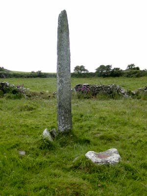
Holed Stone 6 km WSW of Kilcrohane, about 120 metres N of the road to Sheep's Head, near the townland of Ballyroon. Caherurlagh is a very small townland, and once it is located, the stone can be found with local help. When I saw it in the nineteen-seventies it was lying prostrate on the W side of the fence to a field which occupied the site of a stone fort. The entrance to the field was said to be the entrance of the fort. The half-buried stone is 2.25 metres long and the hole is 13 cm in diameter and 12 cm deep. The centre of the hole is 43 cm from one end and 13 cm from one edge. The house nearby used to be occupied by a healing man who, amongst other cures, made a barren sow fertile by laying a hand on her through the hole. The stone has lain prostrate for at least 70 years. ~ (For other holed stones see Doagh, Antrim and Hurlstone, Louth.) Carrigagulla:
Stone Circle Surrounded by an amphitheatre of hills, 2.8 km N by E of Ballynagree and 11.2 km NNE of Macroom, about 150 metres to the E of a good track leading up to the monument-rich Boggeragh mountains, at a point where the track dips into a valley, this fine axial-stone circle, 8.2 metres in diameter, comprises sixteen stones and a misplaced one. They vary in height from almost 90 cm down to just over 30. Unusually, the long, straight-edged axial stone is not the lowest; the highest is next to the lower of the two portal stones. In the middle of the circle is a boulder. ~ About 250 metres N, in the next field, at the edge of a coniferous forest and near the river Laney, is another circle of classic 5-stone, D-shaped type, whose axial stone has a (naturally) bevelled upper surface. ~ Just under 1 km S (W 371 829) is a seriously disturbed alignment of at least four stones, only one of which remains in its original position. Three others were removed and now stand as gate-posts nearby. A fourth may not have belonged to the row.
Another stone-row lies just over 1 km E (W 383 829). ~ Just over 2 km SE
is one of two circles in Oughtihery townland (W 391 821),
a very neat five-stone construction just 3.2 metres in diameter,
with field-stones dumped inside. The overlooking hill feels
important to the site. It and the circle, and a large 4-metre-high
and sculptural standing-stone 2 fields away (W 393 822) form
a line. ~ 2.4 km ESE is Knocknagoun wedge-tomb. ~ 9.6 km SW is Scrahanard wedge-tomb. Castlenalact:
Stone-row and Boulder-burial click
on the thumbnail for more 5.6 km N by W of Bandon
and about 70 metres W of a by-road, this superb alignment commands
fine views and comprises 4 stones increasing in height from
2.2 to over 3.4 metres. A prostrate stone between the two smallest
is not original. In the next field, 400 metres to the N, is
a boulder-burial:
a large rounded boulder is set on 3 supporting stones between
40 and 60 cm high, and a little above a fourth stone.
200 metres from the
alignment (W 486 612) is a single standing-stone 1.4 metres
tall. Cloghboola
Beg: Stone circles, etc. In Millstreet Country
Park, situated
below and within sight of Knocknakilla Hill and its better-known
stone circles - see under Glantane East, below) is a
'complex' of stones and circles described as follows by Ken
Williams:-
~ Just over 3 km NW in Cloghboola More (W 277 872) is another alignment, of one large well-shaped stone over 3 metres high, and two rather smaller ones. ~ 300 metres W of the alignment is a stone circle (W 274 872). Coolineagh:
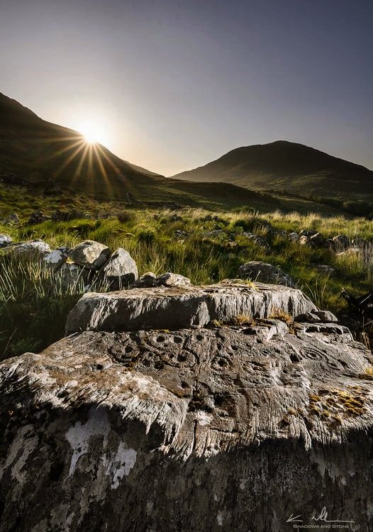
Ogam Stones Less than 20 metres SE of the ruined church of Aghabulloge, 7.2 km NW of Coachford, to the E of a by-road leading NW of the road from Aghabulloge to Rylane Cross, is a damaged Ogam stone 1.5 metres high, also bearing 3 plain crosses, and crowned with Caipín Olainn (St Olann's Cap), a lump of quartzite. Originally there were two superimposed stones, but because of the phallic character and popularity of the monument (as a cure-stone for barrenness, headaches, etc.) a local priest removed them. They were promptly replaced by the present caipín. ~ 135 metres N, in a field, is "St Olann's Stone", a boulder with "the Saint's Footprints". ~ About 400 metres NNE of the church, by the W side of the road, is "St Olann's Well", a corbelled, clochán-like well-house with an ivy-covered hawthorn-tree growing out of it. Nearby is a second Ogam stone, just under 2.7 metres high, which reads RQIDEGO. On the 5th of September there is a pattern around the caipín, stone, and well. This is evidently a site of great antiquity, only superficially Christianised. The country round about is littered with stone circles, standing stones, souterrains, and Ogam stones: ~ 3.2 km N is Rylane stone circle. ~ 3.2 km NW is the more easterly of the two Oughtihery circles. ~ 3.8 km NNW is Knocknagoun wedge-tomb. ~ 9.6 km NNE is Beenalaght alignment. ~ 11.2 km W are the monuments around Scrahanard wedge-tomb. Currakeal:
Stone circle and megalithic landscape The map marks the stone circle, one of several stone-rows (mostly fallen) and a boulder-burial - but there is reportedly more besides (including hut-sites) on a remote plateau above Glengarriff with panoramic views to East, South and West. The nearby laneway seems to be lined with megalithic orthostats. ~ About 850 metres NW, in the 'Burial Ground' marked on the map, is a fine megalithic bullaun. ~ Several kilometres SE, in Gortnacowly (W 088 543) are the dramatic remains of a fine four-poster circle, the tallest of whose three long stones is 3.2 metres high. The fourth stone was apparently still standing at the end of the 19th century.
~ 11.6 km SW in remote Ballynahown (V 843 516) are the remaining two sidestones and a roofstone of a little wedge-tomb offering fine views over Bantry Bay, and aligned to midwinter sunset over a spur of Hungry Hill to the SW.
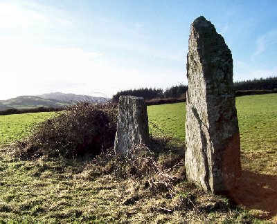
Derreenataggart
West: Stone Circle Situated 1.2 km WNW of Castletown Berehaven and 50 metres N of "The Beara Way", eight of the post-like stones of this neat circle are standing, including one of the radially-set portal stones. The other portal stone has broken, and three other stones of the circle have fallen. The axial stone is a fine slab 1.2 metres high and 2.1 metres long. ~ Almost 1 km east of Derreenataggart is Chaislain Bheara standing stone, fenced in on a rocky outcrop close to some recently built houses (V 673 458). It stands 3.2 metres high, and is very slender. ~ Just under 10 km NNE is another circle of post-like stones at Ardgroom Outward. ~ 3.4
km NNE at Kilmackowen (V 680 495) are a standing-stone
and wedge-tomb. A fine slab some 3.5 metres tall and 1 metre
broad stands on the northwest face of Eagle Hill in the Slieve
Miskish Mountains to the north of Castletownberehaven. A stile
thoughtfully put up by the landowner into the next field leads
to a charming little wedge-tomb on a small raised platform.
Both its sides are formed using single slabs and there is some
close-set double walling on the northern side. The front is
open to the west. A single triangular roofstone covers the unsegmented
gallery. ~ Just under 8 km NE in Cloontreem (V 694 489), spectacularly sited close to the "O'Sullivan Beara Way" in the Slieve Mish mountains above Castletownberehaven is a dramatic but ruined wedge-tomb, with two fine façade-stones still standing like portals, and a large, squarish roof-stone leaning against the only side-stone not to have fallen. ~ Just over 6.4 km N by W is the tall Ogam-inscribed standing stone at Faunkill-and-the-Woods. ~ A little over 8 km E by S, in Ardaragh on Bear (or Bere) Island (linked to the mainland by-road) is a wedge-tomb close to a lane from the old British naval rifle range to Rerrin hamlet. It comprises a collapsed main chamber about 5 metres long, the front (W) end of which is a short portico or antechamber with a septal stone 1.3 metres high. ~ A little over 9 km E by N,on a rocky hillside above the R572 in Derreeny are some fine petroglyphs; a day of fine weather would be required to find them. Drombeg:
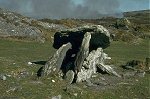
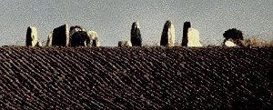
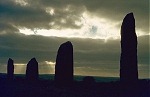
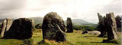
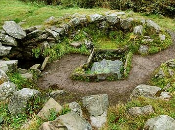
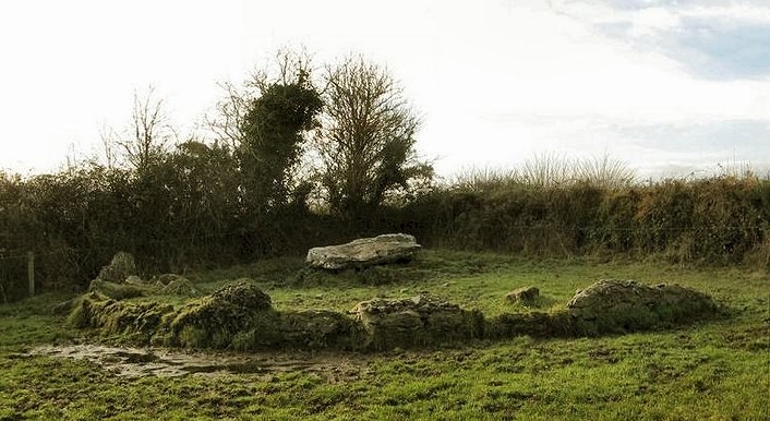
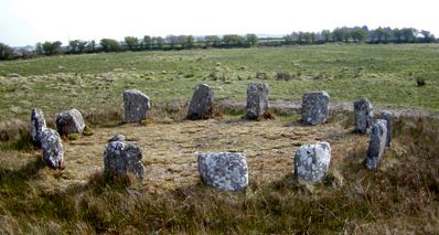
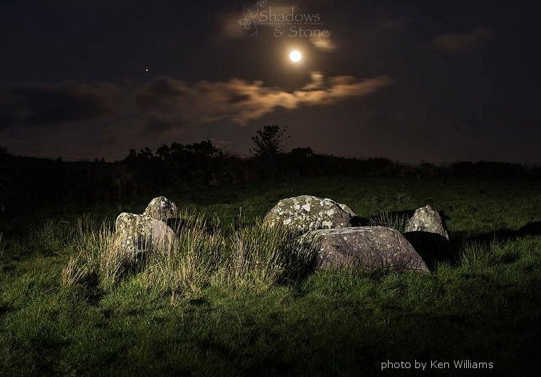
Stone Circle and Cooking-place click
on the thumbnail for larger pictures Thirteen out of the original 17 stones of this impressive circle (2.4 km E of Glandore, 250 metres down a path to the E of a by-road) survive, the most westerly of which is the fine axial, which has two egg-shaped cup-marks, one with a surrounding ring. The two portal stones (1.8 metres high) are as usual on the NE side. Radio-carbon tests on the cremated burial found in the centre of the circle gave a date between 150 BC and 130 AD, though the circle itself is almost certainly Bronze Age. The long-continued use and re-use of sacred sites is not uncommon in Ireland (see Altar under Arderawinny, above). This is one of the few megalithic sites on the Tourist Trail, and it has suffered accordingly from the feet and eating-habits of people who have no particular interest in stone circles or megaliths in general. And instead of the horribly-inappropriate 'official' gravel, white quartzite chips would be much more in keeping with ancient tradition. ~ Just over 30 metres to the W are the remains of 2 conjoined round huts, the larger of which had a timber roof supported by a central post. The smaller hut had a cooking-oven on its E side. From the huts a causeway leads to a cooking-place containing a hearth, a well, and a trough in which water was boiled by dropping in hot stones — almost 350 litres could be boiled within 15 minutes of the stones being dropped in. The presence of the stone circle, huts, and cooking-place suggests that annual or seasonal gatherings took place at a sacred site down to the fifth century AD, the dating obtained for the cooking-place.
~ The stone circles of Bohonagh and Reanascreena South are not far away. Farranahineeny:
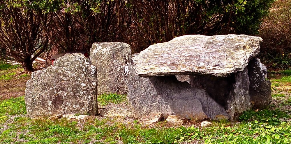
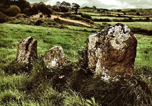
Stone-row This fine alignment, 1.6 km W by N of Poulnaberry Bridge, comprises five stones (some broken), ranging from 1.4 to 3 metres high. It is beautifully situated and commands a splendid view.
~ 2.4 km ESE, in Inchincurka (W 233 596), 1.6 km E by N of Poulnaberry Bridge and 150 metres (in the second low, lush field) N of the road, is a wedge-tomb. Though it has been used as a dump for field-stones, its state of preservation and accessibility make it worth visiting. The narrow wedge-shaped gallery (3 metres long) is covered by three overlapping roofstones. Its characteristic flat façade (facing West) is formed by two stones 1.4 metres high, and much of the tightly-set double-walling survives. There is no evidence, however, of a portico or antechamber.
~ 5 km SSW in Inchireagh (W 190 564) is an easily-accessible but inelegant example of a 5-stone circle, some 2.5 metres in diameter, with a tiny axial stone - and fine views of the hills to the SW. ~ 6.2
km W by N of Farranahineeny, about 1.2 km SW of Cloghboola Bridge,
and about 85 metres N of the road, in Cloghboola, (W
142 613) a small neat wedge-tomb, one metre high with a capstone
2.4 by 1.5 metres, is hidden, unfortunately by a dreary forestry
plantation. I have not yet managed to visit this tomb, nor any
of the other megaliths in the area, including a reported stone-row
at Cornery, about 1 km NE of the bridge and 25 metres
SE of the road (not marked on the map); wedge-tombs in the hills
to the N in Carrigamuck; and "Bord na Rí",
a remote but promising-sounding wedge-tomb in Derryriordane
(W 133 617) just S of a stream flowing down from Douce Mountain.
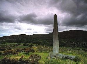
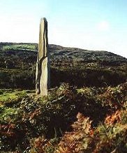
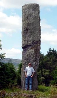
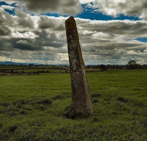
Faunkill-and-the-Woods
(Ballycrovane): Ogam Stone The slender
and splendid pillar-stone stands 5.1 metres high. It is to be
found just over 200 metres SE of the Coastguard Station at Ballycrovane
harbour in a field to the W of the road. Visitors may be charged
for crossing the field, but the stone can be sen well from the
nearby roads. It was probably erected long before the Ogam was
cut into it, because of the bad placing of the upper letters
of the inscription, which reads: ~ 300 m SSW (a short distance SW of the main road) is an axial-stone circle of eight very low stones at the end of a low mound. ~ 3.2 km) E is the stone circle at Ardgroom Outward. ~ Just over 6.5 km S by E is another circle at Derreenataggart West. ~ Close to the village of Knockroe (V 599 413) the slender Cahermore standing-stone, some 3 metres tall, with its broader sides facing east/west, is not visible from the main road, but affords fine views. According to a local informant, the already-leaning stone fell over after a spell of wet weather in the 1980s. His father (plus friends) re-erected it using a JCB. Parking is in a lay-by approximately 250 metres west of the gate to the site. Garrane:
Stone-row 3.2 km NW of Bweeng and 11.2 km SW of Mallow, just visible on the rising slope 200 metres S of a T-junction at the bridge over the Duvglasha river, this fine alignment (or stone-row) offers a panoramic view across the valley of the river Blackwater. It comprises three stones close together and measuring from 2.5 to over 3.7 metres high. A fourth one has fallen. A single stone stands about 100 metres SE, and there is a second row (of 3 stones) 300 metres S, beyond a strip of conifer-plantation. 300 metres ESE is a cashel with remains of circular stone huts inside, and a nearby souterrain. ~ 2.4 km NNW, about 900 metres E by N of Lahuran crossroads, in Gneeves, is another, unusual, alignment of 3 stones whose broad faces are parallel, but not in line. The highest is 2.6 metres. ~ 1.6 km due S, and 20 metres NE of the road from Bweeng to Lombards-town, 4.8 km NW of Bweeng, is Lackendarragh holed stone. It is in an enclosure known as Kilkillin (cut through by the road), which seems to have been an early Christian graveyard. Nearby is a souterrain. The slab is 122 cm high and 2.7 cm thick. At the S edge is a curving hole, probably formed naturally, 5 cm in diameter, 11.3 cm on its long side, and 5 cm on its short side. A report in the 19th century alleged that 'handkerchieves' (probably rags) were passed through it to cure wounds. Skulls have been found round about, and many local stories of supernatural moving lights, etc, are associated with the site. ~ 2.2 km S in Glandine townland (W 482 889) is another pair of standing-stones, sometimes erroneously listed as Monkey's Bridge. They are on a fairly steep, east-facing slope overlooking a relatively deep glen overlooked by the strange phenomenon of Monkey's Bridge, with a fast-flowing stream at its bottom. The N stone is 3 metres tall, pointed and slender, while the other is a more rounded, slab-like stone a metre shorter. This could put them into the male/female category of stone pairs, but it seems more likely that they are the remains of a longer stone-row.
~ 3.6
km SE in Bweeng is a wedge-tomb (W 508 890) which looks
to be intact as you walk up the farm track. All the orthostats
that face you are upright and support roof-stones - all of which
seem to be present. It is not until you get to the tomb that
you see that it is not actually perfect: the orthostats on the
uphill side have all collapsed under the roof-slabs, pitching
them up at an angle. ~ 3.6 km SSE is Beenalaght alignment. ~ 7.2 km ESE is Kilquhane holed stone - see under Greenhill. Glantane
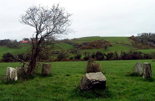
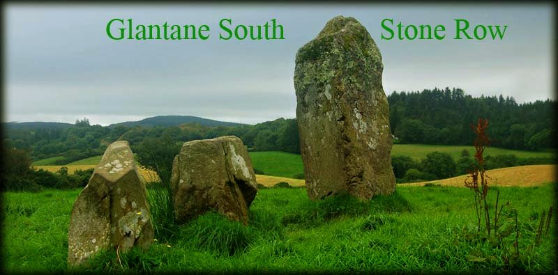
East: Wedge-tomb and Stone Circles Visible to the W of a by-road running N and skirting a forestry plantation, this neat little wedge-tomb (known locally as "The Flags") stands 90 cm high in a field, and has a capstone 2.4 metres square, resting on two sidestones and a back-stone. Some of the double-walling survives, and a small stone 40 cm high splits the entrance between the two side-stones. Although a National Monument, access has been made difficult with barbed wire.
~ Barbed wire also festoons the fence into the next field (to the NW) where there is a stone circle almost 5 metres in diameter, five of whose stones are still standing and six have fallen, some into the surrounding ditch, at least part of which is faced with stone. There are two outliers to the N and S sides, 4 metres tall and recently re-erected - but one has fallen again! In the middle of the circle is a large hole, where presumably a boulder or boulder-burial stood until recently. As with most stone circles, the site commands a fine prospect. It is one of a group of circles with ditch and bank which include Reanascreena South, as well as Lissyviggeen in Kerry.
~ 400 metres SSW, W of the lower road, beside a derelict (maybe now rebuilt) house, up a grassy lane bounded on the N side of spruce-trees, and itself surrounded by trees, in the same townland (W 280 833) is an axial stone circle, 4.7 metres in diameter, of ten stones and a loose flagstone lying beyond the axial stone. The portals opposite the axial are 81 cm high.
~ On the opposite side of the lower road, some 800 metres SSW of the wedge-tomb is an alignment of three stones, one being 2.4 metres high and the other two (broken) surviving to a height of 90 cm.
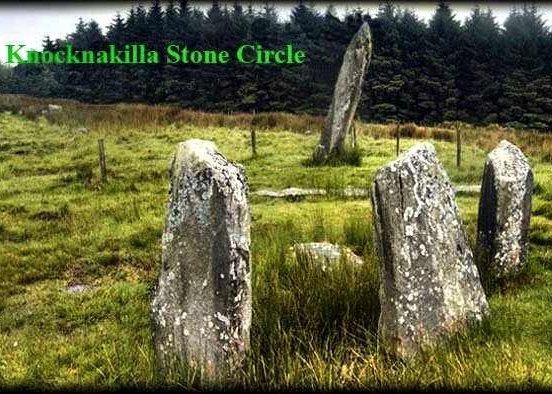
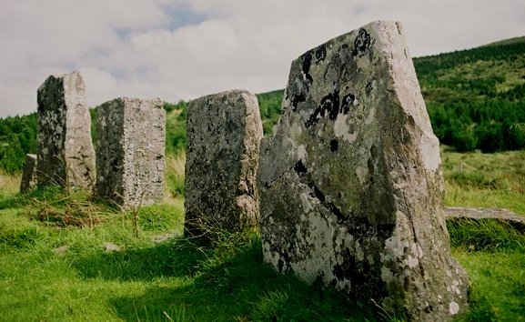
~ 3.2 km NNE is a five-stone circle (three stones undisturbed) with outliers and a radial cairn (similar to the Kealkil complex) at Knocknakilla (W 297 843). The circle has good portal-stones. One of the outliers (over 4 metres long) to the SW of the circle has fallen, but another, though leaning, stands 4 metres high. There are other circles in the townland - and a bogus modern dolmen has been erected. Within sight, in Millstreet Country Park, is the 'complex' of Cloghboola Beg.
~ Just over 1 km SE is a five-stone circle at Carriganimmy (W 293 827). ~ 4 km S are Cabragh stone-rows and five-stone circle (W 278 798). Gowlane
North: Stone Circle 1.7 km S by W of Beenalaght alignment and 3.2 km N of Donoughmore, 400 metres W of the road and at the bottom of the second field NW from a pair of field gates is a perfect circle, 7 metres in diameter. It comprises eight stones (two fallen) averaging one metre in height, two of which, only 90 cm apart, form an entrance to the N with another pair set radially outside the circle, slightly farther apart. This entrance passage, 2.1 metres long, faces a large axial stone: a rectangular slab 150 by 90 cm on the opposite side of the circle. One of the entrance stones has been broken since I first visited the circle in the late nineteen-seventies, and it now seems to be used (with the usual Irish disrespect for antiquities and landscape) as a place to dump large stones dug up by destructive modern machinery. Greenhill:
Ogam Stones 8 km SSE of Mallow,
and about 300 metres S of a by-road, by a hedge on the W side
of a field is a large fragment of an irregular block on which
the clear inscription CATTUBUTTAS MAQ. . .
survives. About 40 metres further, on the other side of the
hedge and bank is a fine, large, tapering stone 2.4 metres high,
on which is the inscription TRENU MAQI MUCOI
QRITTI, together with deep grooves above and below the
N, and other grooves made recently by vandals. Quartz
pebbles abound nearby. ~ 5.6 km SW (9.6 km S by W of Mallow), almost opposite the ruins of a church, and about 10 metres N of a by-road, in Kilquhane, is a holed stone, now prostrate, 1.80 metres long, 70 cm wide and 25 cm on its thick side. Near the thin edge of the stone, 73 cm from the near end and 56 cm from the thick edge, is an irregular hole from 6.2 to 11.3 cm across, and of a depth varying from 5 to 19 cm. This stone, known as "The Sinners' Stone" (Cloch na pecaib), was resorted to by pregnant women, who pulled pieces of cloth through the hole to ensure easy (or at least safe) delivery. ~ Another holed stone is at Lackendarragh, 7.2 km WNW of Kilquhane (see under Garrane, above). ~ 2.4 km SE of the Greenhill Ogam stones is the fine wedge-tomb at Island. Gurranes:
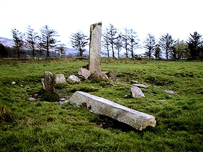
Stone-row click
on the thumbnail for larger pictures 1.2 km NW of Castletownshend, visible on a ridge to the N of theroad to Skibbereen, on the opposite side of the road to Knockdrum fort, three slender pillars (up to 4.2 metres high), known as 'The Three Fingers', rise dramatically against the sky, evenly spaced and set into joints in the exposed rock surface. A fourth stone lies prostrate nearby, out of line. A fifth stone was removed in the 19th century and now stands in the Somerville Estate at Castletownshend. ~ 17.7 km NW are the petroglyphs at Ballybane. Island:
Wedge-tomb 8.8 km SSE of Mallow and 1.2 km E of Burnfort, to the W of a by-road, approached up a lane and through a depressingly-squalid farmyard, this is a fine example of a small wedge-tomb, excavated in 1957. The gallery, 6 metres long, and facing SW, is a single chamber, bounded by typical double wall of stones. Parallel to the gallery is the heel-shaped kerb which connects with the flat façade of the tomb. The thin roof-stones are in situ, and much of the cairn material survives between the gallery and the kerb. Kealkil:
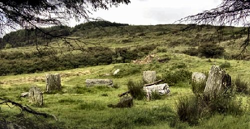
Stone Circle, Standing Stones and Cairn click
on the thumbnail for larger pictures This impressive and splendidly-situated monument is 800 metres SE of Kealkill village and about 180 metres NE of a sharp bend on a steep by-road, from where the tops of the standing stones are just visible. Overlooking Bantry Bay and Kealkill village, it comprises a fine 5-stone axial circle of large stones, with 2 outlying monoliths, the higher of which is now almost 4 metres high. It was originally over 6 metres high. This is one of the few circle sites to have been excavated, and inside the circle was found a setting of crossed timber sleepers which may perhaps have held an upright of wood or stone. Like most stone-rows, the two outliers are on a NE-SW axis, parallel with that of the circle and aligned on a notch in the hills opposite. Nearby also is a small cairn of stones incorporating a circle of small upright stones set radially (see also Knockraheen under Scrahanard). ~ Just over 400 metres
SW of The Kealkil monuments, in the third field on the opposite
side of the road, in Breeny More (W 050 552) are the
remains of a large multiple-stone circle enclosing four boulder-burials
set in the form of a rectangle. All four of their large
capstones are very equal in size and shape and the 'artistic
ensemble' is beautiful. ~ 2 km SSW is a five-stone circle nestling against the south side of a wall in Derryarkane (W 052 537). Two large thorn trees are growing on the south side of the stones (all about 1.2 metres high) make it even harder to detect in the landscape. One of the portal stones has fallen. The entrance and the almost-square axial stone to the SW are aligned with a notch in the distant hills. ~ 2 km ESE in Ardrah (W 069 544) is an alignment of 4 stones, one of which is 2 metres high. ~ 3 km NNW, conveniently beside a by-road in Maughanasilly and overlooking Lough Atooreen (W 044 585) is the fine but uneven row of six stones shown below.
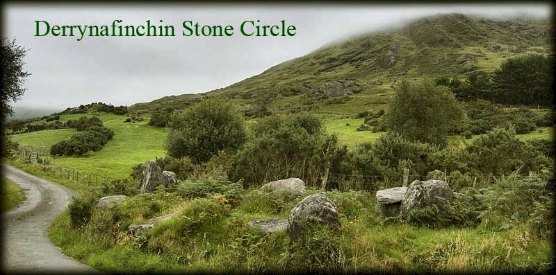
~ 6.5 km N by W, also by the roadside in Derrynafinchin (W 047 622) is an overgrown circle with a large quartz boulder in the centre. A fallen orthostat has a large cup-mark carved into it, and, next to the axial stone is an altar-like structure which could be an ancient addition - or date from Penal times and thus be one of the few surviving "mass-rocks" at a site sacred to at least one older cult. Another large stone within the circle may be a boulder-burial. ~ 5 km ENE is one of two stone circles in Maughanaclea (W 104 565), easily accessible by a farm-lane. With good views to the N, it is over 10 metres in diameter and contains two boulder-burials. Twelve of the original 13 stones survive, six of them fallen. The axial stone is, as usual, long and low. 1.5 km E by S of the first circle, immediately W of a tarred track (W 090 563) is a five-stone circle with an outlier 2.4 metres high. ~ 7.2 km W by N of Kealkil are the boulder-burials, standing stones, and stone circle at Mill Little. ~7.8
km SSW of Kealkil and only 4 km E by S of Bantry is a perfect
five-stone circle at Trawlebane (W 042 470) swamped by
brambles in 2003, and only 1.8 metres in diameter.
~ 10.3 km ESE of Kealkil at Cullenagh (W 151 519) is an intact but overgrown five-stone circle close to a by-road. ~ 11.5 km ESE in Clodagh (W 153 500) is a compact little circle of seven stones (or nine: two stones may have broken in two) just 30 metres above a by-road. The stones (including a very low axial) form a complete ring, so there is no proper entrance. Small quartz pebbles sit on top of the stones that are still standing upright. To the SW, parallel to the axis of the stone circle, are a pair of outlying stones that are of similar height to those of the circle - no taller than 1 metre.
Keamcorravooly:
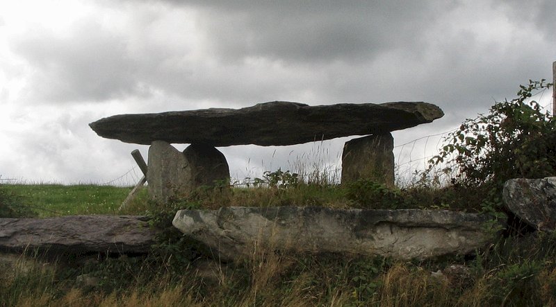
Wedge-tomb 75 metres S of a by-road, opposite a small plantation of spruce trees on either side of the road, some 11.2 km SSW of Ballyvourney and 800 metres WSW of the Bansheelin river, "The Giant's Grave", (An Uaigh an Fhathaigh), is a neat and picturesque tomb about 3.6 m long, with two overlapping roof-slabs, the easternmost of which is supported by a small chocking-stone on top of the backstone. It is markedly wedge-shaped, and retains much of its double-walling. Like most of the Cork wedge-tombs it is low, the entrance being about 106 cm high. It commands a fine view of the hills to the N and W. About 200 metres further up the hill, on a ridge, is a second, ruined, wedge-tomb. The large field in which they stand has been planted with forest which probably now hides the tombs.
~ 5.3 km ESE in Turnaspidogy (W 189 666) is an alignment of three stones around 2 metres high, one of which has fallen. They are set on a little flat shelf on the side of a gentle slope. Modern farming and hedgerows have removed hints as to why this spot was chosen.
Kilmaclenine:
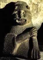
Megalithic Tomb Known as 'Acuthogue', and situated 4.8 km SW of Buttevant and 1.2 km ENE of Kilmaclenine Crossroads, on the left hand side of a lane leading NNW from a by-road, this box-like tomb (an enormous kist ?) was opened in the last century and found to contain 'a skeleton, a sword and some beads'. The roofstone is over 2.75 metres long, supported on two sidestones and a backstone almost 1.5 metres high. The tomb is aligned E-W. To add to its oddness, it seems to be set into a massive mound that has been mutilated over the millennia, now having the appearance of grass-covered sand dunes.
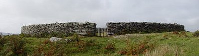
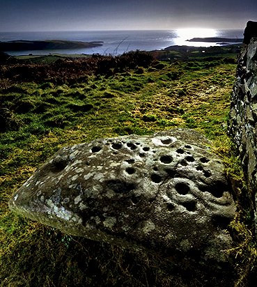
Knockdrum:
Stone Fort, Souterrain, and Cross-pillar 1.2 km W of Castletownshend, on the S side of the road, opposite Gurranes stone-row, approached by a path and steps, this fort was restored in the last century and encloses an area 22 metres across. In the middle is a roofless square stone hut, from one corner of which a 3-chambered lintel-roofed (and now gated) souterrain runs through hewn rock. Just inside the entrance to the fort is a cross-pillar (presumably found nearby and erected here by the restorers). Recently moved to just outside the entrance, and probably not directly connected with the fort, is a large boulder bearing about 40 cup-marks, with a few associated grooves and rings, dating from the Bronze Age.On the right hand side of the entrance passage is a small guard-chamber. The cashel walls stand to a height of around 1.7 metres and are extremely thick.
~17.7 km NW are the petroglyphs at Ballybane. Knocknagoun:
Wedge-tomb 10.4 km NNW of Coachford and 2 km N of Sheskinny Cross, 60m E of a track, a quaint, low tomb, with a gallery about 2.1 metres long, closed at the E end, is covered by 2 capstones. The larger (2 metres long) overlaps the smaller, and they rest on 6 sidestones and a backstone. Round about is some evidence of a cairn. Up to the end of the last century it was completely covered by cairn stones. Attempts to destroy the sepulchre led to several misfortunes, and only the cairn and most of the outer walling have been removed. Knocknaneirk:
Stone circles The more northerly of the two is a fine five-stone circle, 5 metres in diameter, whose taller stones stand some 1.6 metres high. One of them has beautiful solution pits in the top and strange axe-shaped hollows on its flank. The altar-shaped recumbent is 1.5 metres long and 1.1 metres high. 500 metres south of it (W 371 627) is a much larger, but ruined circle, 15 metres in diameter and scandalously unprotected from cattle, with stones of 1.3 to 1.5 metres tall surviving mainly on the North side. ~ Just under 4 km ENE in Currabeha (W 412 640) is a circle of many small stones, 8 metres in diameter and with a quartz boulder in the centre. Its axial-stone is 1.3 metres long and 8 cms high. 400 metres NW (411 644) in the same townland is another more ruined multiple-stone circle of similar diameter, but with a quartz boulder on its circumference, and an outlier some 40 metres NE. The site commands fine views.
~ 2.7 km NNW in Clearagh (W 363 652) is a rock 3 metres long with cup-marks and faint but impressive parallel lines, grooves and double rings.
~ 3.5 km NW in Barnadivane (W 338 643) is a fine pair of quartz standing-stones, 1.3 metres high. ~ 5
km NW in Rossnakilla (W 324 657) is an alignment of
three stones some 6 metres long, whose tallest stone (at the
E end) stands 2 metres high. 50 metres NE is another stone,
slab-shaped. ~ 8.5 km W by N, on a ridge in Knockaunnagorp (W 287 637) is a beautiful standing-stone some 2 metres high, dressed on three of its four sides. ~ Just over 5 km W by S in Reanacaheragh (W 318 627) is a boulder-burial which looks 'just like a dolmen that shrunk in the rain'. A large boulder (with solution pits on the top) covers a small stone lined chamber, the whole surrounded by a small kerb. ~11.5 km WSW is a
fine stone circle at Gortroe (W 259 605) containing
a boulder-burial
and with a quartz
outlier.
2 km SE of Glanworth and 8 km NW of Fermoy, by the roadside, over a wall, this is the largest of Irish wedge-tombs. Three huge capstones (the largest being nearly 8 metres long and weighing 10 tonnes) slope downwards towards the back. The gallery consists of a large rectangular chamber, with a small one behind it, separated by a dividing slab, one corner of which has been trimmed off to leave a soul-hole or ''half-porthole'. The gallery is triple-walled, and buttressed at the back by 3 slabs set parallel with the tomb's axis. In front of the gallery are the remains of a large rectangular, unroofed portico or antechamber, wider than the gallery and cut off from it by a large slab. It is one of many tombs — especially wedge-tombs — to be (latterly) associated with the Celtic Hag-goddess also known as Caillech Bhéarra: Labbacallee (Leaba Caillighe) means "Hag's Bed". Other tombs are associated with the lovers Dermot and Grania in the folk tradition. The sepulchre resembles a French gallery-tomb in size and design, a similarity shared by the wedge-tomb at Burren, Cavan. ~
Just over 3 km WNW of Labbacallee in Moneen (R 746 028)
is a ring-barrow within which was built a Bronze Age multiple-kist
cairn. There is a curiously smooth stone in the S corner. A
food-vessel burial and an urn burial were later added outside
the fosse.
~ Just NW of Glanworth in Ballylegan (R 745 054) is a fine (though leaning) standing-stone well over 3 metres tall, situated some 500 metres (3 fields) from a minor road. One side of it is split, and weathered at the top - though it is not apparent in this photo by "bawn79".
~ About
4 km N by E is the bullaun-stone at Killeenemer (see
under Labbamolaga, below). Labbamolaga
(Labbamologga) Middle: Standing-stones or circle, and 'cursing-stones' In a field close to
a by-road in the townland of Knockanevin are four stones
(one broken) about 1.5 metres high forming a rectangle 5 metres
by 1.5 metres which has suggested to some that it is one of
the few Scottish-style "four-poster" circles in Ireland.
(See also Lettergorman, below.) If so, it is unusually
large. An early 19th century report puts the number at 5, while
locals at the same time averred that there had been 8. The only
indisputable four-stone circle in Ireland is in county Down
at Mullaghmore (see under
Tamnaharry). ~ 9.5 km NW of Labbamolaga, and in county Limerick, is Ballyriggin Standing-stone (R 695 240), of curious shape and close by a lovely stream. It is approached down a track that is used by the Kilfinnane Outdoor Pursuits Centre.
~ In a field close to a by-road about 11 km S by E at Killeenemer (R 776 067) there is a boulder with three very large bullauns up to 30 cm in diameter. Lettergorman:
Stone Circles Less than 800 metres SE of Lough Atariff, about 50 metres S of a narrow by-road, the somewhat-mournful 5-stone circle is nearly 3 metres in diameter, with stones up to 1.5 metres high, the axial stone being 1.4 metres high and a little longer. One portal stone has fallen, as has a large quartz monolith: an outlier that would have occupied a position along the axis in the direction of Carrigfadda hill to the SW. This circle is referred to either as Lettergorman S, or Lettergorman SW. ~ A likely "four-poster" circle lies in the same townland (W 267 473, marked Standing Stones), 1.7 km NNE, comprising 3 stones ranging from 2 to 2.5 metres high, and, 75 metres W another stone which may or may not be the missing fourth, removed for some other use - such as a scratching-post. ~ 800 metres NW, and 5 fields in from a derelict house on the left of the same by-road, in Knockawaddra West, is an alignment of four stones, in descending height, the highest of which is 3.5 metres, commanding a view over the Glashagloragh river valley. When ploughing the adjacent field a farmer observed 'a bright red streak in the soil' extending eastwards from the stone-row. In wet weather it is best not to approach from the W.
~ 3.6 km E of the Lettergorman Southwest circle, and 150 metres (second field) S of the Clonakilty-Dunmanway road, in Knocks (W 300 458), is yet another circle. It has 2 good, tall portal stones, with 5 others visible, and the axial stone is embedded in a fence. The farmer on whose land the circle stands cleared the field and dumped the stones in the circle, which local opinion considered to have been the cause of the mysterious deaths of his cattle. In the same townland (W 303 443) is another circle, eloquently described by my colleague, Ian Thompson: "I am going to stop saying things like 'This damaged site is a great loss', because they are all a great loss! The location of this circle is beautiful...well, it would have been before modern farming encroached upon it. It is nestled amongst a cluster of rocky outcrops, one of which occupies a prominent position 100 metres away along the line of the axis. 150 metres to the south a river carves its way through the land, filling the air with the babbling of water. On this visit this sound had a couple of cuckoos on backing vocals. Five
stones now remain describing a circle 7 metres in diameter.
The axial stone is nice and broad while each of the other stones
are very equal in shape and size. These are slightly taller
than the axial stone and rectangular in plan. The walk past the beat up Ford Fiestas at the start of the farm-track that leads right up to the site is soon forgotten once you reach this place. The site seems to exude a magic, which is amazing when you consider the relatively poor state of the monument. I actually think that this site could have this effect even if you took the stones away, but then I would not have come here to experience it. This location chose itself and the genius loci that called the builders to come here still lives on regardless of 'modern' man's efforts to kill it." ~ 2.4 km S by W of the first Lettergorman circle is another circle at Maulatanvally (see under Reanascreena South). ~ 6.6 km N by W in Ballyhalwick (W 253 521), beside a by-road and a stream are two attractively-chunky survivors of a stone-row.
Mill
Little: Stone Circle and Boulder-burials 7. 2 km due E of Glengarriff, and 100 metres W of the south-flowing Cooleenmane River, 50 metres W of a tributary stream which joins the river at Millbeg Bridge to the E, this 5-stone circle was unusual in having the entrance stones (now disappeared) set roughly parallel to form a short entrance passage — a feature sometimes occurring in multiple-stone circles. W of the axial stone is a beautiful little boulder-burial, like a miniature dolmen only 125 cm high, whose rounded cover rests on three supports. S of this is another boulder, possibly the cover of a second burial.
Farther
S again is a boulder-burial whose cover has been displaced and
lies on the ground. SE of the latter are 2 outlying rectangular
slabs, set close together and aligned NNE/SSW, the larger of
which is 110 cm high. ~ 7.2 km E by S, are the stone circle and standing stones at Kealkil. Reananerree:
Stone Circle and Alignment click
on the thumbnail for a larger picture 4.8 km S of Ballyvourney, 300 metres SE of Reananerree Church and 200 metres E of the road to Ballyvourney, in the middle of a large field is a very small 5-stone circle (or rather an oval) 2.6 metres in maximum diameter, with small stones ranging from 30 cm (the axial stone, in the foreground) to 85 cm in height. ~ 120 metres SE of the circle is a circle of six stones (marked Stone-row on the map) decreasing in height from 150 to 50 cm. It is unfortunately divided in two by a stone fence and a line of spruce trees, but once commanded a fine view. ~ 1.5 km NNE, and 500 metres ESE of the site of demolished Gortanimill House, near the top of a rock outcrop about 80 metres E of the by road from Reananerree to Ballyvourney, in Gortanimill (W 208 741), is a multiple-stone circle of 12 stones about 90 cm high enclosing an area 7.5 metres in diameter, with 2 small quartz boulders in the centre. The site commands fine views, and is one of the few circles which can be viewed from above. ~ 3.1
km NNW of Reananeree, and 2.4 km NW of the Gortanimill circle,
in Gortnatubbrid (W 193 759) is another circle, three
of whose four stones are about one metre high, and the fourth
slightly taller - a characteristic of the rare "four-poster"
type of stone circle. Reanascreena
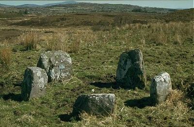
South: Stone Circle 4.8 km NNW of Ross Carbery and 800 metres NW of a by-road at a height of 170 metres, a circle of twelve large stones (2 forming a portal, with the axial stone opposite) is surrounded by a low earthen bank with a shallow ditch, similar to the circle at Glantane East. The axis points WSW and thus, unlike the nearby late circles of Bohonagh and Drombeg does not relate to the sunset at either solstices or equinox. But on approaching this lovely site, laudably well-maintained by the farmer on whose land it lies, the visitor may notice the alignment of the axial stone with a dip in the hills beyond, where the Midwinter sun sets dramatically (though not from within the circle because of trees). Excavation suggested a date of about 1000 BC for an intrusive central burial, but the circle could be several centuries older. ~ There are several other axial-stone circle-sites in the neighbourhood, including one which is 3.2 km due N of the Reanascreena site and 100 metres E of a by-road in Maulatanvally (W 264 442). Only six stones (out of a probably 13) survive, including one portal stone 1.4 metres high, and a tiny axial. Small quartz pebbles surround a central white quartz boulder. This site (like several other megaliths in the neighbourhood) is dominated by Carrigfadda Mountain, crowned with a huge and hideous white Crucifixion, not really triumphing over the sacred, ancient quartz.
~ 4.5 km N is a five-stone circle (W 262 456), and, 6.2 km N (W 267 473 - marked Standing Stones on the map) a likely "four-poster" circle - both in the townland of Lettergorman . Roovesmore:
Stone-row 3.2 km S by W of Coachford, in fields to the S and W of a by-road, situated tangentially between two raths (Iron Age farmsteads) this strange alignment is about 400 metres long. The stone nearest to the road (originally almost 3 metres high) is now prostrate and broken in two. It may have been a single standing-stone. In the next field, to the SSW, is another prostrate stone 4.8 metres long beside a large boulder and a notched, leaning upright stone 3.1 metres high. In a third field, also to the SSW, is a cup-marked stone 1.6 metres high, together with a greatly cup-marked boulder. The fort on the other side of the road to the NNE end of the stone-row (marked Ogham Stones on the map) has a deep ditch between two banks and a line of three low boulders outside it. The entrance of this fort, the first standing stone, and the smaller overgrown fort are all in line - which may or may not be fortuitous. ~ 500 metres W in Rooves Beg (W 452 702) close to a by-road is another stone-row of which one large stone still stands and five are fallen. Rostellan:
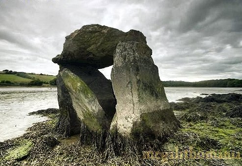
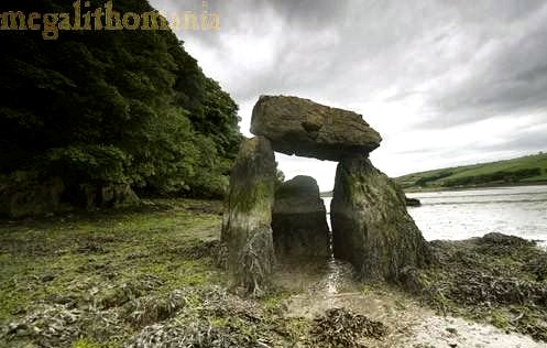
Megalithic tomb This
seaweed-draped tomb is both curious and bleak, situated 10 metres
below high-tide level on the S side of a narrow creek opening
into Cork Harbour some 8 km E of Cobh. Though two metres high,
it does not look at all like a portal-tomb, but is more likely
to be the remains of a megalithic kist. The orthostats are slotted
into the limestone pavement it stands on. The
orthostats are slotted into the limestone pavement it stands
on. My megalithomaniac colleague Tom
Four Winds visited it in 2007 and reported: "A
moderate-sized capstone is held aloft by just two orthostats.
Between these, at the west end, there is another stone forming
the chamber. This looks as if it was the back stone and not
the doorstone.
Rylane:
Stone circle This neat five-stone circle has two matching, block-like entrance stones and a large blade-like axial stone which is leaning into the circle. ~ 1.6 km E by S, close to a by-road in Kilcullen South (W 453 813) and beside a large rath (ringfort), are two standing-stones 1.5 metres high, with a prostrate slab in between. The western stone has a very weathered ogam inscription. On the other side of the road are two standing-stones, one of them prostrate. ~ 2.7 km SW is the more easterly of the two Oughtihery circles (see under Carrigagulla). ~ 3.2 km S are the standing-stones at Coolineagh. Scartaglin:
Stone circle This isolated monument affords spectacular views. To the East rise the mountains of the Dingle Peninsula, and to the south The Paps of Anu are a dramatic presence. Four stones of the circle still stand upright, one of which is presumably an outlier of what was a five-stone circle. Next to these there are at least seven other stones that are very similar to the ones still standing. Might this have been a unique pair of five-stone circles ?
Scrahanard:
Wedge-tomb 6.4 km N by W of Macroom, by a field-fence immediately to the W of a narrow by-road from Carriganimmy to Macroom, 500 metres NW of a junction, "The Bealick" is a 'National Monument' engulfed by brambles - and the landowner has tried to prevent access: so much for "State Care"! It is a well-preserved tomb with a capstone 2.3 metres by 2 metres wide, its gallery intact as well as most of the double-walling. The backstone of the gallery, and the sidestones adjoining it, have scratched marks on the inside face, more lightly incised than those at Baurnadomeeny, Tipperary. Crosses were scored on the outside face of one of the stones in the last century. In the same field stands a single slab and also what looks like an untouched cairn. Beyond the cairn is a souterrain.
~ 70 metres SE of the circle is a cairn with radial stones on its perimeter, surrounded by a ditch and an outer bank. Two other cairns lie about 130 metres NE of the circle. The group seems to have been a large single ritual complex (compare Kealkil). ~ The area around Macroom and Coachford is very rich in prehistoric remains, especially standing-stones and stone-rows. ~ In the adjoining townland of Lackaduv, on the other side of the road, approached by a track opposite "The Bealick" and situated on a rocky slope, is an impressive wedge-tomb. The capstone is 2.4 metres long and 1.8 metres wide. Much of the double-walling has survived. ~ In Knockraheen, 1.6 km NNW of "The Bealick", a short distance to the N of the same road (W 303 802) is an elegant 5-stone circle with a long, low axial, low axial, and remains of an alignment (two fine quartz stones 1 metre high still standing and a third prostrate) 40 metres away on the same axis.
From here, amid a dramatic landscape, can be seen the two large standing stones on the ridge of Knockraheen mountain. 100 metres NE is a large radial cairn, over 8 metres in diameter: a low pile of stones with most of the radially set stones still in situ. ~ 4 km W by N of "The Bealick" are two stone-rows in Cabragh. See also under Glantane East. ~ About 7 km NW, just 2.8 km ENE of Macroom and 9.6 km W by N of Coachford, up a tarred lane and over 3 fields to the N. In a field about 400 metres from the river Laney and 1.6 km NE of Macroom (New) Bridge in Bealick (W 362 741) stands a small, denuded tomb with a large capstone 360 by 210 cm and 45 cm thick, and a wide, natural groove running its entire length. The overall height of the tomb is 1.5 metres. Templebryan
North: Stone Circle Immediately E of the road, 4 km N of Clonakilty, are the remains of a fine large stone circle, of which only 5 large stones — all flat-topped — out of a probable 9 now survive. These include the axial-stone, and one of the portals which is almost 2.1 metres high. In the middle of the circle, which is about 10 metres in diameter, is a quartz boulder.
~ Some 300 metres NW is a neglected enclosure containing graves, a ruined square oratory, a souterrain, a holy well (‘Tobernakilla'), a bullaun, and a fine tapering monolith 3.3 metres high, low down on whose W face is a worn cross-pattée and a faint Ogam inscription reported to read ANM TENAS MACI V. . . They were both carved on an existing standing stone which may have had some connection with the stone circle.
~ 4.5 km WSW in a nondescript situation at Ballyvackey (W 344 426) is a ruined circle of which seven stones survive, including the axial and one entrance-stone.
|
 photo
by Derek Ryan
photo
by Derek Ryan
 click the picture for a view of the circle
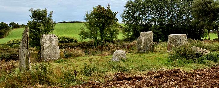