county list
![]()
|
Turn smartphone to horizontal
view. SELECTED SITES IN COUNTY WATERFORD Place-names in italics refer to listed entries. Convert Irish Grid references to Latitude/Longitude |
|
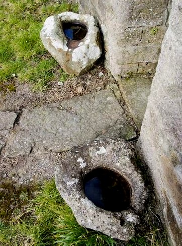
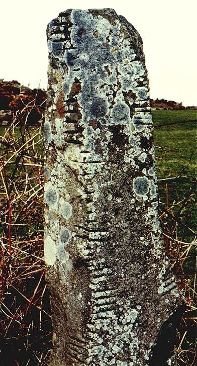
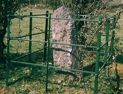
Two ogham stones have been moved inside St Declan's ruined cathedral with its splendid interior Romanesque arcade. St Declan is said to have floated over from South Wales on his tombstone before the arrival of St Patrick - one of a plethora of charming and poetic legends attached to Irish saints. One of the ogam-stones - a square-sectioned stone about 1.2 metres high with ogam script on all four edges - has been erected in a protective niche in the wall. It has two inscriptions: LUGUDECCAS MAQI...COI NETA SEGAMONAS (A stone in memory of Lugaid, scion of Nia-Segmon) and DOLATI BIGA ISGOB. The other stone lies on the floor looking rather lost and abandoned. It is of remarkably phallic shape - probably the reason why it has not been put on 'proper display'. The ogam on it is very hard to see - perhaps due to much rubbing - but it reads AMADU - Beloved. Ballynamona
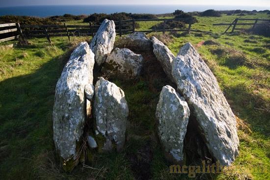
Lower: Court-tomb This remote site is
Ireland's most-southerly court-tomb, just one hundred metres
from a cliff, from which there are fine views eastwards along
the coast towards county Wexford. The tomb is protected by a
rather rustic-looking fence, which (as usual) cramps it. Of
the court - originally 7 metres wide and 6 metres deep - only
a few of the large orthostats remain, but the gallery, on the
other hand, is well-preserved. The entrance is marked by two
very small jambs set inside the front edges of the large wall-slabs
which demarcate the gallery. Where these stones meet there is
a single slab that divides the gallery into two chambers.
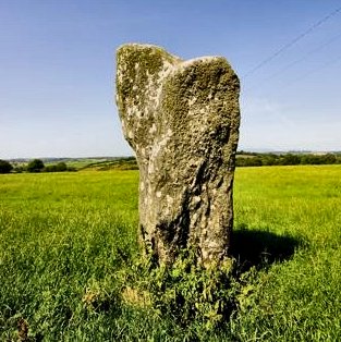
~ 6.2 km WNW in Ahaun (X 228 852) is a standing-stone beside which a concrete trigonometrical marker has been placed. It is a slab some 40 cms thick, 2 metres tall, and 150 cms wide at the top, here pictured with only the shadow of the trig-marker showing.
~ 500 metres W of this, in Monaneea (X 225 848), is another stone, about 1.6 metres high. ~ 7.9 km W (X 210 827) at Kilcolman (3.1 km SW of Ahaun), is a third stone standing at the corner of a field next to a road junction. It is rough and irregular, about 1.4 metres tall, and leans slightly to the west. Ballyquin:
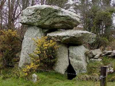
Portal-tomb and Ogam-stone This picturesque
small portal-tomb is NW of a holy well by the roadside and 200
metres N of the road. Its capstone is 3.6 metres long by 2.4
metres broad and just over 1 metre thick. It is supported at
the front end by two unmatching portal-stones 1.5 metres high,
unusually set so as to form a flat frontage with a small doorway
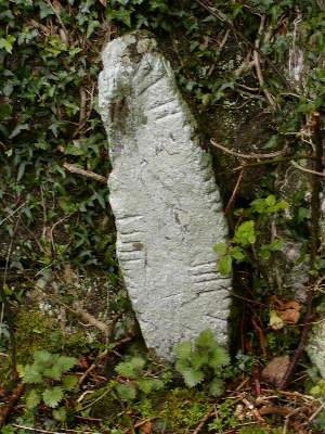
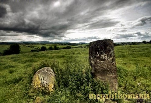
slightly off centre.. No other structural stones survive. ~ 1.5 km NE of the tomb, crassly placed behind a gatepost on the W side of the by-road running S from Piquet's Crossroads is an impressive 2.4 metre high Ogam stone which reads CATABAR MOCO BIRIQORB - which may mean 'Battle-head tribesman of Chariot-man'... Of pebble-encrusted mudstone, it was moved to its present undignified position some 200 metres from the top of the field. ~ Less than 1 km NNE at Crehanagh (S 419 196) is a standing-stone with a broken top which was later 'memorialised' with an ogam inscription. It stands 2 metres tall and may have been a metre higher.
~ 4.5 km SSE in Whitestown East (S 425 138) is another, similar, tomb whose impressive mudstone cap, 4 metres long and encrusted with quartz pebbles, rests on one portal-stone. The other portal has fallen into the chamber. A fast flowing stream runs around the bottom of the field and fills the air with a lovely bubbling sound which is counterpointed by birdsong in spring and summer.
~ 8.2 km ESE at Kilbunny (S 482 135) are two bullaun stones moved to flank the doorway of Kilbunny church. One of them is oval about 50 cm long and 25 cm wide. The other is circular and about 40cm across.
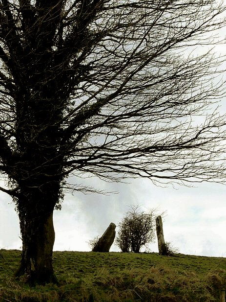
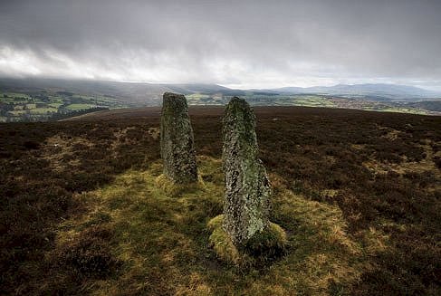
~ 6.4 km W at Ballinadysert (S 358 200) is a pair of standing-stones about 1.5 metres high and some 15 metres apart, suggesting that originally there were at least 4 stones. A local man has written to say that, according to local lore, these stones mark the place where two Butler brothers fought a duel in which both were killed. Coumaraglin
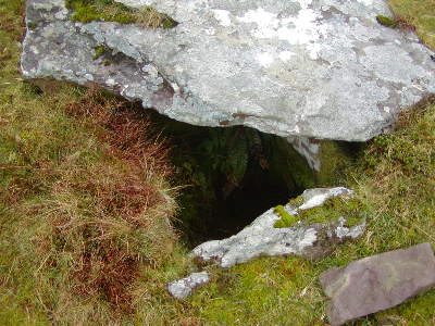
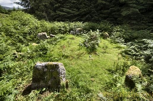
North-West: Cairns and Stone circles The reference above is for a low cairn with a partially-open double-kist whose capstone has been slid aside.
~100
metres N is another, higher cairn with a large ruined kist some
two metres long by one metre wide and deep. 300 metres further
N (S 268 047) is an untidy stone circle with two small but obvious
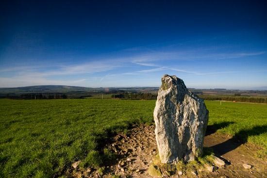
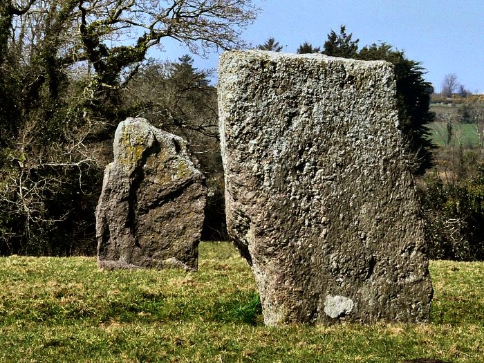
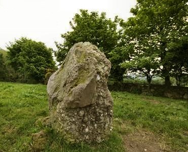
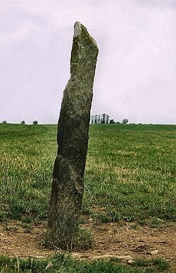
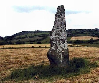
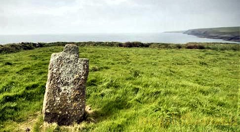
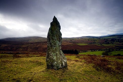
external portal-stones. ~ On Coumaraglin Mountain (S 272 018) is a standing stone some 2 metres high, with an elegant profile and a commanding position on an open area of heathland. 361 metres ESE of it is another standing-stone, leaning, with a bit broken off, in Crohaun. Coumaraglin Mountain standing-stone
~ 3.2 km S of Coumaraglin NW is an ogam stone, now kept in the garden of Comeragh Lodge, Kilcomeragh, under a large shrub, which seems to be providing some protection from the elements. This does make it almost impossible to see the inscription properly though. The stone originated somewhere in the Knockalafalla-Rathgormuck area. a previous owner of the house was travelling in the Rathgormuck area when he saw some workmen about to use it as a gatepost. He recognised it as an ogam stone and offered them a new, concrete gatepost. Much of the inscription is still visible. MacAlister read it as LUGUDI MAQI L...D...QA MOCOI DOMM(A). ~ 5 km W by N is the ogam stone at Knockboy. ~ 7 km NNW, in the adjoining Comeragh Mountains, at Toureen or Tooreen (S 249 116) on the Waterford 'dolmen trail', is another stone circle 4 metres in diameter with several stones missing, and a possible outlier to the E. 300 metres W of it (S 246 117 and farther along the trail in Toureen West) is a stone-row comprising 4 stones from 40 to 110 cms high.
Drumlohan:
Ogam-stones
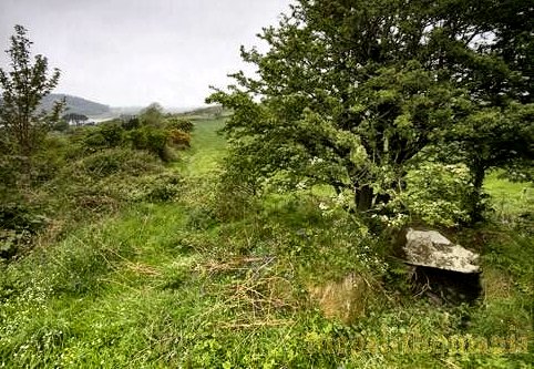
5.5 km SW of Kilmacthomas, across 3 fields to the E of the road to Stradbally are the remains of a souterrain which was part of a monastic site and which, not untypically, used 10 old Ogam stones as roof-lintels. Some of these have now been erected above ground, and are handsome. ~ 50 metres SSE of the souterrain is a bullaun-stone. ~ 8 km NNE at at Rathmaiden (S 384 091) is a stone-row of stones around 1.8 metres high (and marked as a single Standing-stone on the map) along the side of a hedge and fence. One of the stones is slightly out of line ~ 8.2. km N in Ashtown (S 363 095) is a pair of standing-stones. The map has just a single stone marked here, but there are two, separated by a field wall. They are situated on a gentle west-facing slope with views to the E obscured. To the west the Monaghvullagh Mountains dominate, and to the north is the beautiful lone peak of Croughaun Hill. The western stone is a smooth, quartz-veined slab about 1.6 metres high. The other is a knobbly conglomerate stone with interesting pebbles embedded in it. According to the owner of the land, the stones used to be scattered about the surrounding fields. He told my colleague Tom FourWinds a nice tale about his mother using the smooth standing stone as a signalling device. When the farm labourers were out in the fields -before they had watches - she used to place white or news-paper on the top of the stone to let them know when food was ready.
~ A short distance SSE (S 360 090) in the same townland is another stone with similar views, a conglomerate about 1.4 metres tall shaped like an up-ended wedge of cheese. ~ 11.5 km NE in Ballyhussa, close to a by-road near a crossroads (S 445 085) is a fine, slender standing-stone over 2 metres high.
~ 3.2 km NNW in Garranmillon Lower is another stone pair (S 352 041), each stone bearing a very worn ogam inscription on its W edge. The W stone is 2 metres high and slim. The other is shaped like a spear and leans somewhat. 30 metres to the east of the pair is an unusual enclosure that is built on a steep slope. Inside this there is a rectangular drystone platform and the floor area is scattered with stones. Gaulstown:
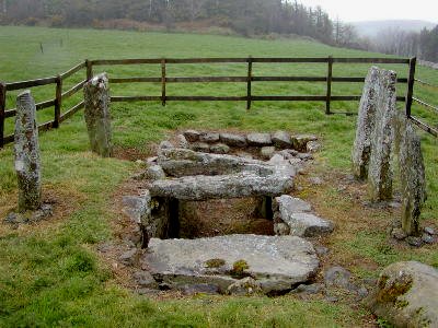
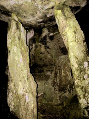
Portal-tomb 8 km SW of Waterford and 400 metres SW of Lisnakill Crossroads, this fine megalith has a capstone nearly 4.5 metres long upon six uprights, the two portal-stones jutting out to form a kind of porch. Between them is a closing-slab as in many other portal-tombs, especially in the SE of Ireland.
~ 1.7 km SSW of Gaulstown is a fine standing-stone at Ballymote (S 533 048) almost 4 metres high and with a profile reminiscent of an Easter Island statue.
~ 2 km N of Gaulstown at Whitfield (S 540 084) is a tall standing-stone some 3 metres high with a strange protuberance on one side, which has given it the recent name of "The Harp Stone". It is up a short, overgrown farm-track on top of a ridge, close to barns and trees.
~ 3.6 km E by S is another portal-tomb in Knockeen (S 577 061), whose portal-stones also project. The doorstone reaches up to within 38 cms of the larger of two capstones (3.8 metres long) which rests on the smaller.
~ 450 metres SE of the Knockeen tomb at S 577 061 in Munmahoge, is a wedge-tomb in a little glade bounded on one side by two very large slabs. No cairn remains and it is difficult to say what relationship the two large stones originally had with the monument. The larger certainly doesn't have the right shape to have been a roofstone. If it was part of the kerb then the kerb was massive.The east-west aligned gallery is more complete on the south side. At least two wall slabs are missing from the north side. There is a solitary roofstone in place at the west end and a second one leans against the outside of the south wall. The site is on a gentle north facing slope, just 20 metres from where the it starts to run steeply down to the stream below. If this wasn't behind a hedge the views to the N would take in Knockeen portal tomb and the rocky ridge beyond. To the west one would be able to see the rocky outcrop known locally as the Sugar Loaf. ~ 3.5 km SW in Ballynageeragh (S 495 031) is another portal-tomb, also with a large and a small capstone, here supported on 4 orthostats. This tomb has been inaccurately reconstructed with the unfortunate use of cement.
~ 4 km SSW is Matthewstown passage-tomb (see below). Harristown:
Passage-tomb On top of a low hill about 600 metres N of Fairybush Crossroads, this low tomb commands a fine view and is the most impressive of a group of County Waterford passage-tombs which resemble those of the Scilly Isles off Cornwall in that the chamber and the passage are one. The wedge-shaped passage/chamber and the partial doubling of the side walls in this example show some influence from wedge-tombs. Only 2 roofstones survive. The sepulchre is surrounded by remains of its cairn, and a kerb of orthostats broken at the entrance to the passage/chamber in which there is a low sill-stone. ~ 5.6 km SSW in Ballymacaw (X 654 988) is a formerly-whitewashed standing-stone known as The White Lady. The top has been shaped and given 'shoulders', making it look quite human. It stands just 30 metres from the edge of high cliffs. If it is indeed prehistoric, and related to the statue-menhirs of SW France, this stone suggests that the anthropomorphic cross-pillars of the Early Christian period carried on an ancient European tradition as much as a Coptic one.
~ 15.4 km W by S is Matthewstown passage-tomb (below). Kiltera:
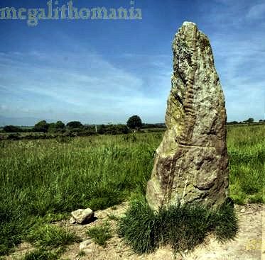
Ogam-stone In a graveyard to the E of a by-road, 1.5 km S of Villierstown, stand two Ogam stones with inscriptions referring to the god Lug, which the excavator (in 1934) deemed to be pre-Christian.
They read: COLLABOT MUCOI LUGA MAQI LOBACCONA (Collabot son of Lug son of Lobchu) and MEDUSI MUCOI LUGA.
Knockanaffrin: Standing-stones Harder
to reach than the map would suggest, three stones stand overlooking
the valley of the river Nire, with superb views. Two are about
1.7 metres tall and apart, but the third one seems to have been
snapped off, for it is just 30 cms. high.
~
400 metres W, at S 266 142 is an unrecorded stone circle, not
listed in Moore's survey of these hills but described here by
Tom
FourWinds: The remains are difficult to see, but several
factors point to its authenticity. Firstly it is in its own
little field: someone at some time made sure it was safe by
giving it its own walled-in area. Luckily one of the visible
stones is the axial stone, which is, appropriately, on the NE
side of the circle. This means the axis is northeast-southwest
- a classic alignment for an axial stone circle. The other seven
or so visible stones form a circle about 15 metres in diameter.
It stands on a small shelf at the base of a rough southwest
facing slope. This means all the views are directed towards
the SW and W towards the Knockmealdown Mountains. ~ 1.7 km SE in Carrigeen is a single, handsome, pointed stone, standing about 2 metres tall in a lovely setting.
Knockboy:
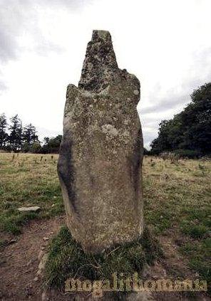
Ogam-stones Three ogam-stones have been re-used as lintels in the ruined church, and inside the building is a fourth, free-standing and painted white.
~ About 400 metres NE (S 219 052) is an alignment of four stones, one of which has fallen. The heights range from 80 cms at the NE end to 150 cms at the SW. ~ 5 km E are the various standing stones of Coumaraglin. ~ 6.4 km NW is a stone pair at Aughavanlomaun (S 167 088) marked as a standing stone on the map - but definitely a pair, the taller of which is just under 2 metres high, square and smooth-sided. The shorter is quite different - lending further credence to the hypothesis that such pairs represent male and female.
Matthewstown:
Passage-tomb About 800 metres up a lane leading S of a by-road, in a field to the W, this tomb has a wedge-shaped passage which is also a chamber formed by 10 low orthostats, and retains three impressive roofstones. The site commands fine views. ~ 2.4 km ENE, in Ballinaclogh South (S 550 041) is an impressive standing-stone some 2.2 metres high, with a jagged top.
~ 2.5 km ESE at Carrickavrantry (S 551 018) is a little wedge-tomb situated in a little dell beside an old trackway. Much of the low mound is still around the tomb, which still has one roof stone in place. The chamber, exposed at one end, is about 2 metres long by 80 cms wide, with a height of just 60 cms.
~ 6 km ENE in Carriglong (S 591 050) is another passage-tomb with similarities to the larger example at Harristown (above). Its entrance also faces NE, and its passage also gets higher and wider as it enters the cairn (of which 21 kerbstones remain), forming a chamber about 2 metres in diameter. ~ 15.4 km E by N is the passage-tomb at Harristown (see above). for other monuments not listed on this
page |