county list
![]()
|
Turn smartphone to horizontal
view. SELECTED SITES IN COUNTY CARLOW Place-names in italics refer to listed entries. Convert Irish Grid references to Latitude/Longitude |
|
Ardristan:
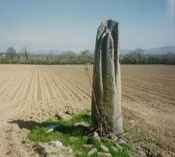
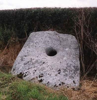
Standing-stone This is the finest of several vertically-grooved stones in north Carlow, south Wicklow and south Kildare. It stands in a field by the E side of the N 81 Tullow-Bunclody road, some 2.8 metres high, with 6 furrows radiating down from the top. Reminiscent of the famous "Devil's Arrows" in Yorkshire, the grooves are only partly artificial. All these stones are of a granite containing sparkling crystals of feldspar. 50 metres to the W is another, much smaller, stone, undistinguished and ungrooved. A new road will pass between them. ~ 2.2 km E by S in Rathglass (S 864 712) is a fine pair of stones some 1.6 metres high stones and aligned east-west. Both have a triangular profile, but one is more pointed than the other, which suggests a male/female pairing similar to Boherboy, county Dublin, Moneyslane, county Down, etc. The eastern stone has faint ogam on its two west facing edges, while the western stone has two fine cupmarks near its base. ~ 2 km SSE in Aghade is an unlovely but curious flat stone with a circular hole in it 30 cms in diameter, known as "Cloch a' Phoill" or the Holed Stone and the object of many legends and beliefs. (see Doagh, county Antrim). As with the Hurlstone, county Louth, it may be the perforated door-slab of a vanished megalithic tomb. There are remains of other tombs in the vicinity.
~ About 1.5 km SSE of the holed stone, to the N of Aghade House, is a conspicuous standing-stone 1.8 metres high, with a vertical groove on one side. ~ 800 metres SE of the holed stone, in Aghade Fox Covert, approached through Aghade Lodge or Cullaghmore House, at Aghade Bridge, in Cullaghmore townland (S 856 692), is a partly-collapsed portal-tomb, whose massive, much-grooved capstone (with ?cup-marks) is almost 4 metres long, over 3 metres broad and 2 metres thick (to be compared with the one at Haroldstown, below). It has been estimated to weigh 15 tonnes. The underside, however, is quite smooth. One orthostat, 2 metres high, is now prostrate, and the sole supporting stone is just under 1 metre. The tomb is at the N end of a denuded cairn some 30 metres long. The river Barrow is just 30 metres away. ~ 1.6 km SSE of the holed stone, close to Aghade Bridge, in a wood on the E bank of the river Slaney, in Ballynoe, about 30 metres W of the road to Ardattin, are the remains of another sepulchral monument with a small capstone, and a small standing-stone nearby. Ballinasilloge:
Megalithic tomb (hybrid ?) Known (probably only
fairly recently) as The Banshee Stone, this tomb has
been classified as a portal-tomb, but has characteristics in
common both with wedge- and with court-tombs.
~ 3.5 km NW is a portal-tomb at Kilgraney. ~ 7.5 km SE is a standing-stone at Rathgeran. Browne's
Hill (or Browneshill): Portal-tomb The single capstone
of this partly-collapsed dolmen, 3.2 km E of Carlow town in
the townland of Kernanstown, is reputed to be the heaviest
in Europe, weighing 100 tonnes. It rests on 3 uprights 1.8 metres
high, and on two prostrate boulders. A fourth upright stands
nearby and might possibly be the remains of a forecourt. The
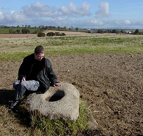
extent of the burial-chamber cannot be determined. ~ 2.7 km SE, in Busherstown (S 778 755), is an earth-fast flat-topped boulder 1.4 metres square, framing an unusually-deep bullaun 30 cm in diameter, nearly 60 cm deep and - like several Carlow bullauns - conical. It is said to have wart curing properties - if the wart-bearer visits the stone three times. There is an old graveyard nearby and the field is known as 'Church Field', so an old church probably stood nearby. A new trunk road through this field was planned, but geophysical research revealed a lot of activity below the surface and so the site was left alone and the road located elsewhere.
~ Just over 1 km N by E of the Busherstown stone, on the other side of the R.726 in Johnstown (S 774 766), below a huge beech tree in the grounds of a country house, oddly surrounded by a modern stone circle formed from tall, square-sectioned granite pillars, is a conical stone with a tapering depression 30 cms deep which is nearly 20 cms square at the top. This may be a bullaun-stone, or something else entirely - conceivably a gatepost-socket of some antiquity or even the base of a small granite cross. Haroldstown:
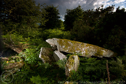
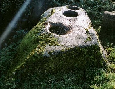
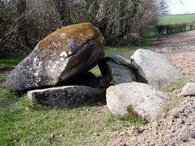
Portal-tomb Clearly visible in a field to the S of the old bridge over the Derreen river, 7.2 km NE of Tullow, this fine granite tomb has a door-slab some 1.8 metres high between the portal-stones. The larger of the 2 roofstones is much grooved and it is possible that some of the grooves are artificial as in other monuments in the area. The tomb was inhabited in the 19th century and maybe well before. ~ 2.4 km NNE in Williamstown (S 913 798) is one of several grooved standing stones in the area (see also under county Wicklow), known as "The Six Fingers". It is 1.8 metres high, of granite, and has 5 large vertical grooves. ~ 4.8 km NE (5.5 km E by S of the village of Rathvilly) in Tombeagh is another grooved granite stone, 1.5 metres high, and of grotesque shape, with grooves and depressions in it which are all natural. ~ 6.5 km ENE (S 963 761 on Sheet 62), signposted, close to the road and almost in a stream at Clonmore is a massive, long boulder with three bullauns on the top all in a row.
Kilgraney:
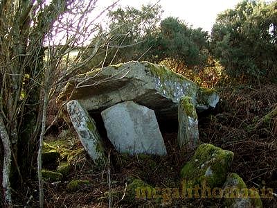
Portal-tomb In a hollow, just 5 metres from a little river, this collapsed portal-tomb is a charming megalith in a delightful setting. The capstone is a large flat slab about 60 cm thick by more than 5 metres long and 2.5 metres wide. It is now supported on just one stone.
~ Just under 11 km SE is the petroglyphic boulder at Rathgeran (below). Rathgeran:
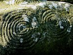
Petroglyphic boulder click
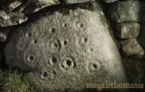
on the thumbnail for high-resolution pictures Hidden in bracken underneath a gorse-bush some 8.8 km NE of Graiguenamanagh, this superb boulder has fine views to the SW. For those with a GPS locater, the more accurate grid reference is S 78793 48043. The top surface features two sets of concentric rings (7 & 8 rings) most beautifully engraved in the granite, the centre cupmarks of which are joined by a gutter (rare in Ireland). To the east of these is a 7-turn spiral. Below it is a 6-ring concentric motif also with a gutter, to the west of which is a faint 6-turn spiral, above which are two very eroded spirals or concentric rings. The hillside is strewn with boulders, and the area is rich in petroglyphs. Another boulder with cups and rings is marked on the map at Gowlin a little to the south. ~ In Rathgeran Upper (S 793 472 - GPS S 79270 47219) is a panel measuring around 150 x 100 cms now incorporated into a wall. There are at least 12 cup and ring motifs on this stone, one of which has two rings and a gutter. Running down the right side is a line of four cups and rings. The rings around two of these intersect each other, making them look like a figure of eight.
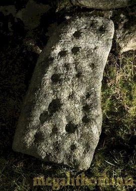
~ Also in Rathgeran Upper (S 792 476 - GPS 79177 47574: not marked on the map) and now standing against a field boundary not far from where it was found, is a stone about 100 cms high and 30 cms wide, with 23 ringless cup-marks on one surface.
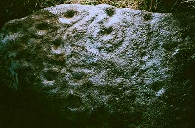
~ In Rathgeran (S 802 473) is a standing-stone around 1.6 metres high. ~ Just over 3 km SW (5.6 km NE of Graiguenamanagh) in Tinnacarrig (S 758 470), is another (more eroded) granite boulder liberally decorated with ringed cup-marks. It is on the edge of a field to the NW of the road to Kiltealy, and also difficult to find.
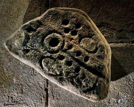
~ In a 'heritage museum' inside the former Church of Ireland at St. Mullins (with ruined abbey and 'high' cross, 6 km SSE of Graiguenamanagh) is a very fine piece of rock art related to the above, and brought from Dranagh. Though labelled as a copy, it has every appearance of being the original stone, according to Ken Williams,who took the photo below.
~ 7.5 km NW is the hybrid megalithic tomb at Ballinasilloge. ~ Just under 11 km NW is the portal-tomb at Kilgraney. |