
county list
![]()
|
Turn smartphone to horizontal
view. SELECTED SITES IN COUNTY SLIGO Place-names in italics refer to listed entries. Convert Irish Grid references to Latitude/Longitude |
|
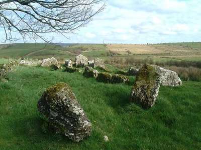
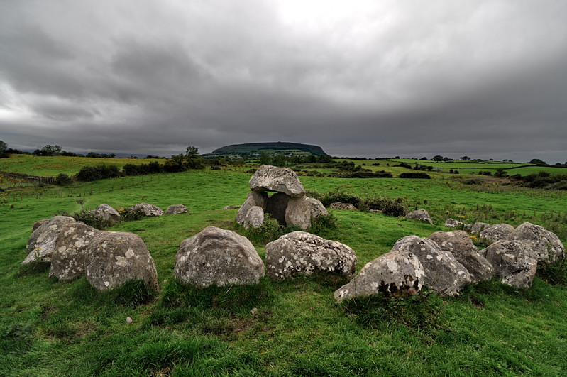
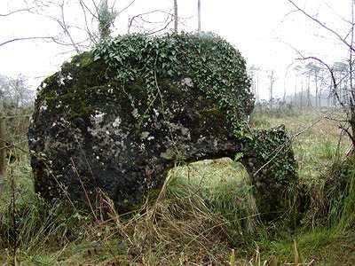
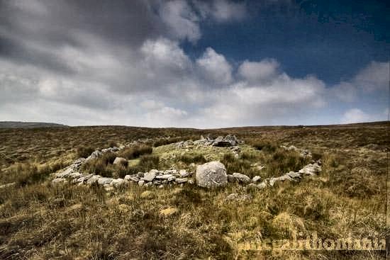
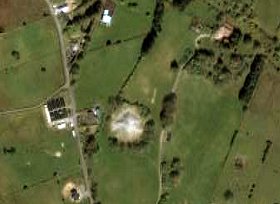
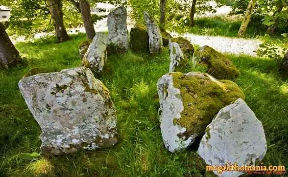
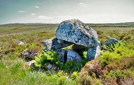
This is the most westerly
of a group of tombs between Coolaney and the Ox Mountains and
one of two in Cabragh. It is a large and imposing wedge on a
site affording good views. Some of the roofstones survive, slipped
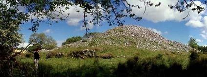
and tilted against the gallery-stones on the S side. My colleague
Ian Thompson writes: "Looking down on to
this tomb from the road 30 metres above, it looks a complete
mess, but closer inspection reveals a wonderful monument. The
appearance of messiness is caused by the displaced roofstones
which stick up out of the gallery. ~ 1.3 km SE in the
same townland (G 568 242) is another - but more damaged
- wedge tomb lying in a dip two fields in from the road. My
colleague Ian Thompson writes: "The
tomb occupies rough pasture on a southwest slope. 150 metres
to the northwest is an area of exposed rocky outcrops. Knocknashee
pokes its head above the top of the bank to the southeast. This
is possibly the only surviving tomb where Knocknarea does not
appear on the horizon. The gallery is about 6m long and defined
by two slabs on each side and the spikiest backstone I have
ever seen. A massive roof-slab, 3.5 metres x 2 metres long,
rests against one side of the tomb. 30 metres behind the tomb
there is a large slab flush with the ground, which seems to
have a chamber beneath it. A line of stones joins this to the
tomb. To the northwest there is a second flat slab lying with
its long axis at right angles to the gallery. ~ 5.2
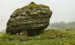
km S (G 568 201) at Knockatotaun is a portal-tomb with
some affinitites to wedge-tombs. Its large, horizontal capstone
(measuring 3 by 4 metres) is still in place. Its underside look
as though it has been worked to some degree. It rests on many
orthostats, nearly all of which are encrusted with worm fossils.
The long axis of the chamber is NW-SE, with the broader end
at the southeast. The orthostat below the 'rear' end of the
capstone has some handsomequartz veins running through it.
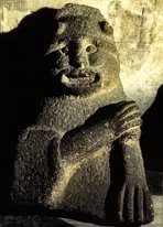
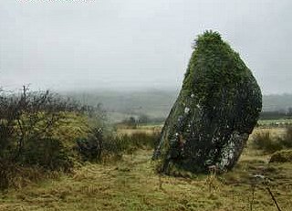
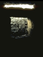
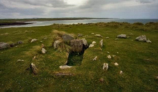
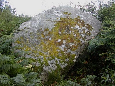
~ About 5 km S of Knockatotaun in Achonry is a boulder-burial, about which the only information I have is the photo below.
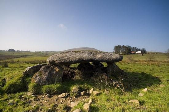
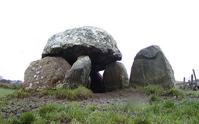
Carrickglass:
Portal-tomb Known
as "The Labby [Rock]", ('Labby' is an anglicisation
of the Irish word for 'bed' - as in 'Dermot and Grania's
Bed', this tomb, 7 km SE of Riverstown and 7.2 km NNW
of Ballyfarnon, is best found by following the signs for "Cromlech
Lodge" (a well signposted hotel) from Castlebaldwin. A
path zig-zags through the woods until the dolmen suddenly appears
- behind a wall. This remarkable and endearing megalith has
a huge limestone capstone 2.5 metres thick, 4.5 metres long,
and 2.75 metres wide, weighing some 70 tonnes. It is a veritable
hanging garden of vegetation, and appears to be driving the
ridiculously puny portal-stones and backstone into the soft
ground. The entrance is marked by a low thin door-slab. ~ 1.7 km ESE in Moytirra West (G 807 151) is a small round cairn with surrounding bank which had a double kist in the centre, and which yielded the first examples of Irish bronze-age 'bell-beakers'. The townland name preserves that of a legendary plain, Magh Tuireadh, also known as Moytura, in which two cosmic battles were fought. ~ 2.5 km SE in Moytirra East (G 815 141) is a court-tomb that I failed to find in 1972 because of a misprinted map-reference. Its four-chambered gallery is over 11 metres long, with a large court facing NNE, and has an unusual double (or split) entrance like some Ulster wedge-tombs (such as Dunnamore, county Tyrone), suggesting that it might be a late example influenced by - or influencing - wedge-tombs. There are several standing-stones in the vicinity, up to 3.5 metres high, some prostrate: perhaps part of a greater megalithic complex. The nearest is 100 metres S of the tomb in the next field.
~ 2.4 km W is the huge cairn of Heapstown. Carrowkeel-Keshcorran:
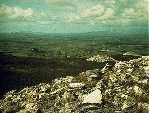
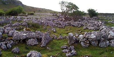
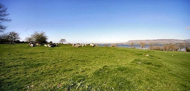
Passage-tomb complex Approached via a tarred track leading E from a by-road running from North to South through the hills, and well-signposted this megalithic cemetery is superbly situated on limestone ridges in different townlands, of which Carrowkeel is only one. There are cairns in Keshcorran to the W, as well as a dozen tombs and two megalithic kists in the main necropolis, which has clearly been laid out with an eye to the unique landscape of rocky spurs. There are magnificent views from the cairns over Lough Arrow to the E, and N to Knocknarea and Ben Bulben. Some of the rock-faces are steep, and there are extensive patches of peat-bog and heather on the ridges and in the deep fissures.
Of the other tombs, Cairn F (now ruined) is the finest, with double-transepted chamber shaped like a Cross of Lorraine, and a (now-collapsed) roof of corbels assisted by squinches and packing-stones. Between the inner pair of recesses was a broken pillarstone, at the butt-end of whose fallen portion human ashes had been placed. In this and some other tombs some of the large stones are of sandstone. These may have been placed at points of particular stress where limestone would soon collapse. In fact, some of the lintels in Cairn K are cracked and dangerous. I am told that at Midsummer
the sun as seen from Cairn A rolls down the side of Keshcorran
(also spelled Keishcorran) to the NW, 'and sets over the Cairnaweeleen
notch'. Cairn G has a 'light-box' of earlier and cruder construction than the famous one at Newgrange. Whereas the Newgrange box permits a shaft of light to penetrate along the passage of the tomb into the chamber at the winter Solstice, the Carrowkeel one was designed to "trap" the light of the setting sun at summer Solstice, and the light of the setting moon at the winter solstice and Lunar Extremes. Cairns M and N have only a few stumps of orthostats left, and Cairn C is unenterable. Cairn B, dramatically sited at the N end of a promontory W of Cairns F and E in Treanscrabbagh townland (G 745 116), has the most commanding position of all the tombs. Within a kerbed cairn 22.5 metres in diameter and 5 metres high is an accessible, fairly-crude pentagonal chamber with two sillstones at either end of a passage.
On a commanding limestone ridge to the NE of the complex in Mullaghfarna (approachable from the N via a seemingly-natural stairway in the cliff) is a cluster of nearly 50 stone rings known as "the village". Some are too large to have been roofed, so they may have been tent-shelters for ritual occasions. Most form a continuous line along the E edge of the ridge, and are aligned with Knocknarea on the northern horizon. There is no evidence to connect them with the same early Neolithic period as the supposed necropolis. Below "the village", also in Mullaghfarna, is an undisturbed wedge-tomb.
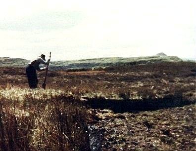
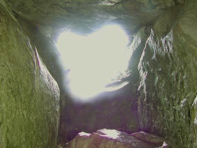
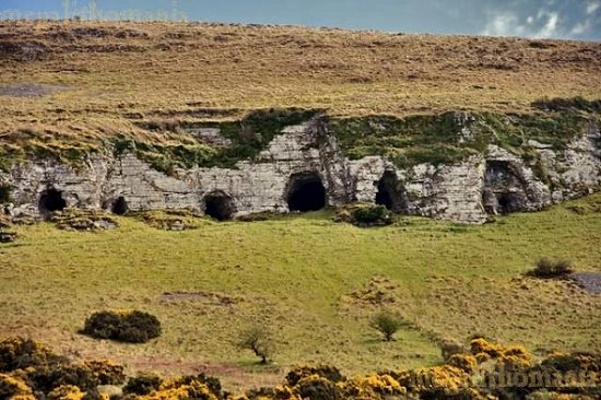
~ Lower down and on
the west side of Keshcorran mountain (G 706 122) are several
caves, which are visible from the road. The cave with the largest
entrance appears to go back quite some distance into the hill,
and offers spectacular views.
~ 1.5 km NE of Kesh Caves in Carnaweeleen (G 717 132) is a disturbed passage-tomb known locally as Carnaweelaun, originally cruciform but now somewhat scattered with displaced roofstones and collapsed uprights. One roofstone lies to one side, propped up against taller orthostats, which are a little over 1 metre tall. These could mark the corners of the central chamber. Situated on a north-east spur of Keshcorran Mountain, it offers fine views to the N and E towards Carrowkeel and beyond.
See
Martin
Byrne's excellent web-site for more information
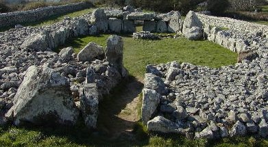
Carrowmore:
Megalithic complex click
the thumbnail for a larger picture
Although concentrated in the townland of Carrowmore (rather too close to the county town of Sligo for its preservation), there are also passage-tombs in other neighbouring townlands - most of them ruined and looking like portal-tombs. The cemetery is dominated by the kerbed tumulus of Misgán Méadbha (Maeve's Cairn, Lump or Pimple) on the summit of Knocknarea: unopened but almost certainly containing a passage-tomb or megalithic kist. It is 55 metres in diameter, over 10 metres high and round about it are the remains of several tombs and cairns. It was in this area that passage-tombs - and stone circles deriving from their cairn-kerbs - were developed in Ireland, moving East across Ireland and into Britain and Brittany as they got more elaborate. The Carrowmore necropolis may have had as many as 80 sepulchres originally; now only 60 can be traced, because of gravel quarrying and other schemes such as municipal dumping to fill in gravel pits! They are now protected (from commercial, but not from 'official' damage), and there is (of course) a Visitor Centre. The Sligo passage-tombs belong to different periods. The earliest are the simple 'boulder-circles' of Carrowmore. click
the thumbnail for larger pictures These may be the ancestors of all the stone circles of Atlantic Europe, which enclosed simple small boulder-built chambers. Occupying the edge of Carrowmore plateau, these mostly align towards a 'ritual centre', and were not built to impress or be seen from afar. A date late in the fifth millennium BC has been established for one of the boulder-chambers, making it the oldest known building in Europe. They have been interpreted as quiet sacred places of an egalitarian society which lived close by, on especially-good land with a climate favoured (rather than battered) by the sea, which was also, of course, the main highway until late mediæval times. This might have been a matriarchal society which inevitably made the mistake of allowing boys to form secret societies and play with big stones - and big clubs.
Later on, tombs or shrines with high visibility and prestige were built away from Carrowmore on the Slieve Gamph or Ox Mountains to the SW. Some of them had more complex cruciform chambers and large cairns. The dead were now distanced and elevated from a more stratified society with a labouring class, and the shrine-houses of the dead no longer fitted into the landscape, but dominated it. The third phase is represented by the huge cairns of Misgán Méadbha on Knocknarea, and Listoghil in Carrowmore - which, it seems likely, were constructed rather later than their burial-chambers. These complex monuments required huge labour-resources, and must have been built by a fairly totalitarian society. Later still, the highly visible hilltop cairns on Carrowkeel, all supervised by the all-seeing and probably baleful eye of Misgán Méadbha, were built as a kind of new necropolitan annexe to the already venerable sacred area of Carrowmore. The best way to view the Carrowmore Sacred Landscape is to walk along the by-road which runs North-South to the W of Cloverhill House. Many of the denuded tombs and kerbs (which of course are not stone circles), including Listoghil, the most prominent monument in the complex, can be viewed to the W. Interspersed among the passage-tomb remnants are stone kists, standing-stones and a holed stone (difficult of access because it is surrounded by drains and electric fences!) in the townland of Tobernaveen to the extreme NW of the complex (G 665 350).
It looks remarkably like the door-stone to the court-tomb at Corracloona, Leitrim, and is very likely the last vestige of such a tomb. Through this stone babies were passed to ward off the many infant maladies that for so many centuries afflicted Ireland with a child mortality greater than almost anywhere else in Europe. It was still being used in 2001. For more about the stone and its use, see the Voices from the Dawn website. ~ About 600 metres NW of the Tobernaveen stone is a fine stone-row in Barnasrahy, photographed below by Martin Byrne.
~ 1.3 km NNW of Barnasrahy stone-row is a court-tomb at Cummeen (G 657 366) - one of several remarkable court-tombs in the NW of Ireland, such as Magheraghanrush and Creevykeel (also in Sligo), Tullyskeherny and Tawnymanus (Leitrim), and Cloghanmore (Donegal). This one may be the most intriguing.
The remains
are clearly that of a central court tomb minus the court. Two
galleries stand facing each other some 5 metres apart on an
E-W alignment. The E gallery is the more complete and it is
possible to tell that it was divided into two chambers, because
one of the dividing jamb stones is in situ. The other, more
ruined, is roughly the same size and design. Each gallery is
about 4 metres long and over 1.5 metres wide. The entrance jambs
into each gallery are present and well-matched. Sligo town itself occupies
the area most favoured for living and burying in Neolithic times. ~ Surrounded by a housing-estate in Abbeyquarter North on the outskirts of Sligo town (G 700 357) is a boulder-kerb some 12 metres in diameter - contemptuously turned into a roundabout and grotesquely Christianised by cast-iron Calvary figures. click
on the thumbnail for a larger picture
Recommended reading on both the
Carrowkeel and Carrowmore complexes See
Martin
Byrne's excellent web-site for more detailed information,
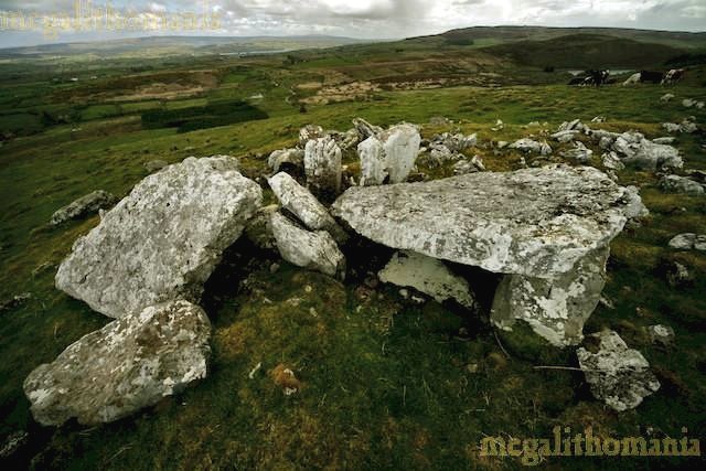
Carrowreagh:
Court-tomb 3.2 km NW of Aclare, at a height of about 250 metres and extremely difficult to locate across featureless bog lie two court-tombs embedded in the peat. The more southerly (to which the grid reference above applies) is probably the best-preserved in Ireland. Entry can be made only through a small hole in the roof, which is corbelled with high-pitched slabs in two and three tiers over low orthostats. As with the tomb in Carrowleagh in county Mayo (some 9.6 km NNW) the court is entirely concealed by cairn and bog. ~ 300 metres N is a wedge-tomb with a low, modern wall - obviously constructed of cairn-material - surrounding the remains of the cairn. The court would have been at the north-west end, but this area is in total disarray. The gallery is in a much better state, and, unusually, diamond-shaped. The entrance is just under 2 metres wide.
~ 6.4 km SW is the fine wedge-tomb in Carrowcrom, Mayo.
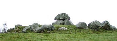
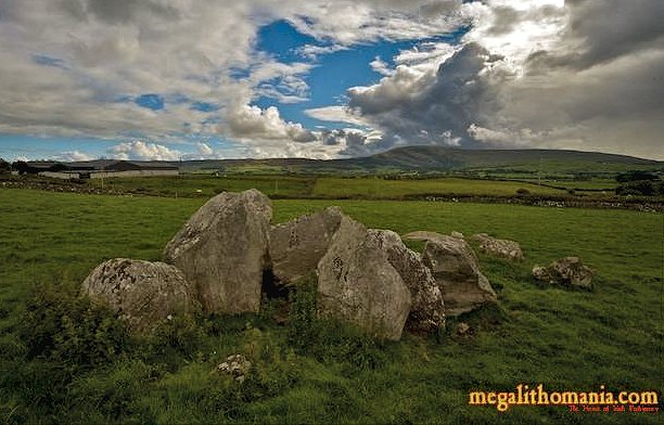
Clogher: Stone Fort Known as "Cashelmore", the fort is inside the Coolavin Estate some 14 km WSW of Boyle, romantically sited amongst trees, and approached through a gate. It was restored in the 19th century and is built of stones which get smaller as they get higher. Inside are three sets of steps leading to the ramparts, three wall-niches, and two souterrains. Creevykeel:
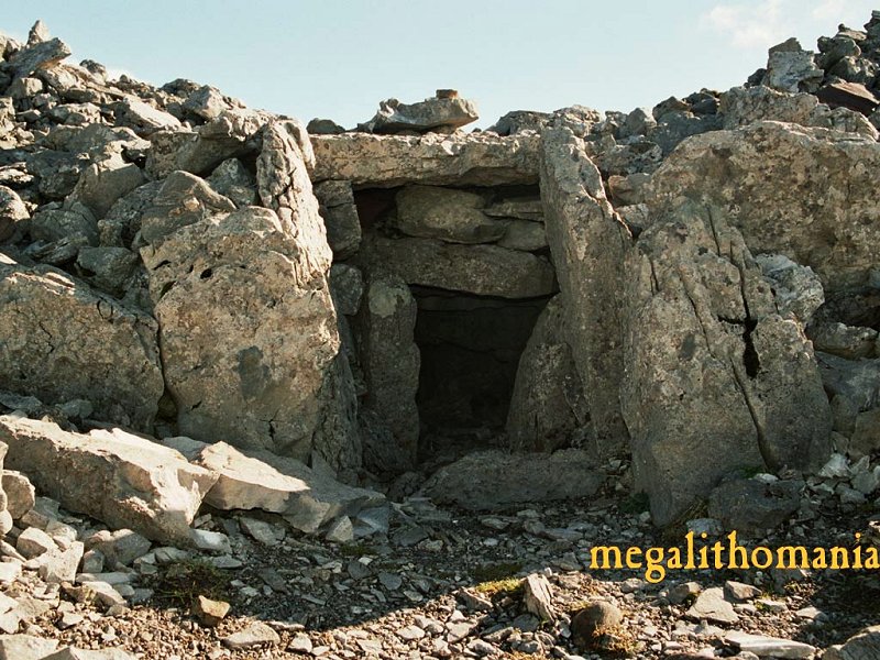
Full-court tomb This very fine, excavated
tomb lies immediately E of the noisy and busy main road from
Sligo to Bundoran, a few metres N of Creevykeel Crossroads.
It is contained in a wedge-shaped cairn which was originally
nearly 60metres long. The broad end faces roughly E, and from
it a short passage leads into a large oval court (with somedry-walling)
about 15 metres long. This in turn leads into a 2-chambered
gallery with vestiges of corbelling in the rear chamber. Only
those orthostats nearest the entrance to the gallery are of
megalithic proportions, some of them 1.8 metres high. Behind
the gallery are the remains of 3 single-chambered subsidiary
tombs, apparently built at the same time as the rest of the
monument. On the S side the cairn is double. On the NW part
of the court are the remains of a much later kiln, and evidence
of iron-smelting was found there when the tomb was excavated
- see just above the centre of the photo below.
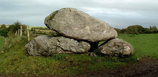
~ 9.5 km WSW of Creevykeel is a small wedge-tomb at Streedagh (G 629 504), exposed by a storm which removed some of the sand dunes that once covered the area. The roofless gallery is just 3 metres long, but has well-preserved double-walling. It is entered through two matching stones with a door-stone in between - which was broken when some vandals lit a fire in the gallery. The circular kerb - some 10 metres in diameter - is almost complete. Good overhead views of the tomb can be had from sand-dunes nearby.
~ 12.8 km SSW in Coolbeg, about 900 metres NW of the 12th century cross and Yeats' grave at Drumcliff ("- horseman, pass by!"), about 200 metres W of the bridge over the Owney river beside a grove of cherry-trees, (G 673 424) is a large limestone wedge-tomb with trees growing through it, whose main chamber is almost 7 metres long, over which one (slipped) capstone remains - with at least one cup-mark on it.
There is an antechamber or portico and a good façade of stones about one metre high. Much of the double-walling survives. ~ 16 km SW (7.4 km W by N of Coolbeg) in Cloghcor (G 599 438), facing N on the highest point of a ridge, is a portal-tomb in a passage-tomb situation. The weight of the roofstone has collapsed the chamber and it now lies behind the portal- or entrance-stones which are 2 metres high, and which may not have directly supported the roofstone. There are fine views S over Sligo Bay to Knocknarea.
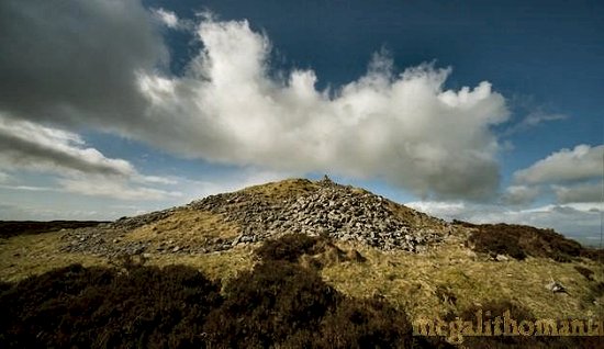
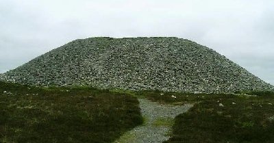
Heapstown:
Cairn Immediately to the E of a by-road leading to Riverstown is a huge cairn over 60 metres in diameter and 6 metres high - said locally to have been piled up on a single night by non-human forces. Being on low ground, its enormous size and massive kerb suggest that, like Listoghil in Carrowmore (above), it contains a passage-tomb.
There are reports of decorated stones and an Ogam stone which used to be near the cairn. A kerbstone on the S side has barely-decipherable glyphs. (For a discussion of the Sligo passage-tombs, see Carrowmore, above.) ~ 1.6 km W at Barroe (G 799 144) is a possible megalithic tomb with a craggy capstone 1.8 metres thick and wide similar to the capstone of the portal-tomb at Carrickglass, 2.4 km E of Heapstown.
~ Three crannógs in Lough Arrow are marked on sheet 25. Magheraghanrush
or Deerpark: Centre-court tomb The fine views to be
had from this huge tomb are now blocked by insensitive planting
of dreary conifer forest, which is to the S of the road from
Leckaun to Sligo (6.4 km to the E). On the top of a ridge overlooking
Colgagh Lough, the tomb has an impressive central court 15 metres
long, from which 3 two-chambered galleries extend to give the
tomb a length of 30 metres. Two are on the E side and one on
the W. One of the E galleries still has a lintel in place (though
broken) above the jamb-stones. The court is entered from the
S side, and the tomb (also known as Leacht Con Mhic Ruis)
has some similarities with the tomb at Ballyglass, county
Mayo. Below the monument, approached by the path from which the path to the court-tomb branched off, are other remains including a ruined wedge-tomb, a souterrain, and a trivallate stone fort with souterrain (G 750 366) which offers splendid views towards Slieve Dargan. ~ 8.5 km SSW, on the
other side of Lough Gill, close to a by-road in Carrownagh
(G 732 285) is another sprawling (single-)court tomb with massive
stones, and a long gallery divided into (possibly) three sections.
There is an impressive square backstone at the W end, and good
jamb-stones indicate that there are two distinct chambers. There
may be a third chamber at the east end but this area contains
some cairn material, possibly not all original, and a large
stone which may be a displaced lintel. This may be the area
of the court. One of the embedded stones appears to be out of
line with the gallery and suggests that the structure widened
at this point to form a court. Slieve
Dargan (Carrownamaddo and Castledargan townlands): Passage-tomb 'Calliagh a Vera's
[Caillech Bhéarra's] House' is not on the highest peak of
Slieve Dargan, but on a lower peak to the west. Slieve Dargan
blocks the views to the east and northeast, but the views to
the south, west and north are extensive.
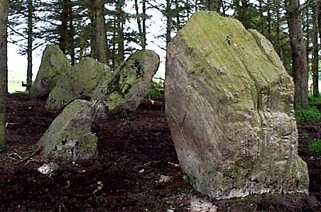
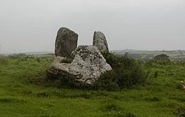
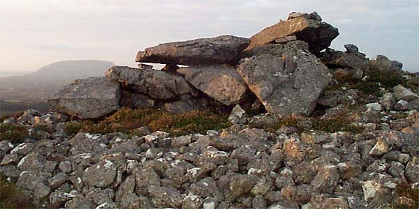
Tanrego West: Court/Portal-tomb G 596 307 Sheet 25 Just under 5 km SW of Knocknarea, this tomb is picturesque in a sylvan setting, and is a 'hybrid' or intermediate between a court- and a portal-tomb. It has massive entrance stones about 2 metres high. The half-door stone between them is a feature of portal-tombs and is a reddish sandstone, in contrast to the greyish limestone of the rest of the tomb. The first (and only remaining) chamber of the gallery is formed by two massive orthostats which are not in line with the two entrance/portal stones. This also is a feature of portal-tombs. There is no back-stone to the gallery - which ends in two opposing jambs. Many other stones are scattered about, some of which might be roofstones, others from the court, and yet others could be from the original kerb.
~ 5.8 km NW in Ardnabrone (G 550 343) is a wrecked portal-tomb. Tom FourWinds recounts the lore pertaining to the wreckage of this and other tombs around the country: There was once a magic cow that lived inside the chamber and would fill whatever container you placed beneath its udders with milk, without ever going dry. One day someone got greedy and placed a sieve beneath the cow to fill many jugs with milk. The cow, realising the mean trick that was being played on her, reared up, dislodged the capstone and ran away...
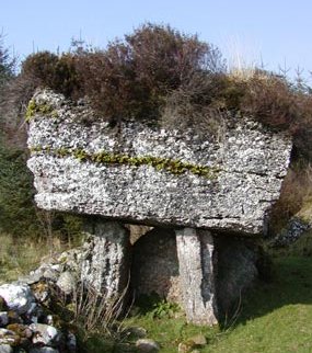
~ 6.6 km SW is one of the wedge-tombs at Cabragh. Tawnatruffaun: Portal-tomb G 400 282 Sheet 24 Once
visible a few hundred metres E of a by-road following the valley
of the Owenwee river, 8 km SW of Dromore West, this tomb is
now the magical centre of a large clearing in a conifer plantation.
Known as The Giant's Griddle, it has a fine slab-like
capstone 2.8 metres long, tilted appropriately and resting on
2 well-matched portal-stones about 1.5 metres high (between
which is a low 'half-door' stone) and only just resting on the
backstone. One of the sidestones has disappeared, allowing the
chamber to be seen clearly. Cup-and-ring designs are reputed to be on two stones of the wall/fence in which The Giant's Griddle is incorporated. ~ 2.5 km NE is another (less impressive) portal-tomb at Crowagh (G 421 294) with a good door-stone between its squat portals. Its long cairn - with signs of a kerb - can be traced to 18 metres behind the chamber. Despite the collapse of the massive capstone, which has crushed the chamber and pushed the portal-stones and door-stone forward to about 60°, the tomb is still over 2 metres high. ~ 2.8 km N by E in Knockanbaun (G 402 307), in the centre of a very thick clump of trees and scrub is portal-tomb similar to that at Crowagh but with a small capstone - which was, nevertheless, heavy enough to have crushed the chamber and forced the portal stones forward.
~ 2.6 km WSW at Caltragh (G 376 270) are the remains of a court-tomb largely surrounded by peat. From the road, the remaining huge roofstone can be seen. Other stones, including a horizontal supporting stone beneath the west end of the roofstone can be seen if you make the somewhat treacherous journey across old peat-cuttings.
|
