county list
![]()
|
Turn smartphone to horizontal
view. SELECTED SITES IN COUNTY WESTMEATH Place-names in italics refer to listed entries. Convert Irish Grid references to Latitude/Longitude |
|
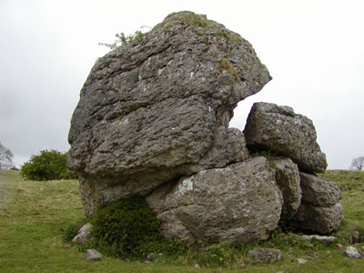
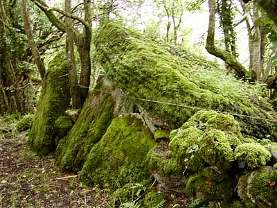
The Hill of Uisneach is traditionally the centre of Ireland, and one of the island's legendary places of power. Scattered about its slopes are various raths, cashels, souterrains - and 'St Patrick's Well and Bed', a rectangular platform or altar of stones on one of the summits of the hill. The Cat Stone (properly Aill na Mireann, Míorán or Meadhrán meaning the stone of swoon, rapture, or transporting dizziness) on the southern side of the hill is a huge and impressive, crumbling, once-phalloid, natural rock, surrounded by a small, shallow henge next to a beautiful hawthorn glade, which contains other significant-looking, grooved stones. Its trees are festooned with coloured (and fading) ribbons left as meanly-modern offerings.
A correspondent who wondered why I had not earlier included the site in this gazetteer adds a modern footnote to the considerable folklore attached to the Cat Stone: "I had wanted to visit this
place since the summer of 1959, but was unable to do so until
August of 1978. My wife and I arrived at the Hill, but I could
not bring myself to go onto the site - at least not from the
road. I couldn't understand why, as I had travelled from Strokestown
specially to visit this stone. Porterstown:
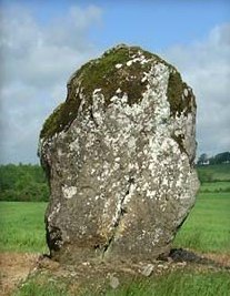
Standing-stone Close to a by-road, in a field behind a bungalow 1.7 km SW of Killucan, a slab-like stone stands some 2 metres high by 1.5 metres wide.
~ 1.5 km NE in Killucan, immediately E of a by-road running S from the village, beside three shamefully-neglected 16th century wayside-crosses in an enclosure, is a bullaun-stone, some 1.2 metres across and 1 metre high, with a single deep bullaun nearly 30 cms in diameter. ~ 10 km N by W in Johnstown (N 548 613) is another standing-stone, only 1.2 metres high but nicely wedge-shaped, on an eminence surrounded by marshy fields with views NNW towards the Loughcrew passage-tombs of Slieve na Calliagh in Meath, is only 1.2 metres high. Moyvoughley:
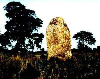
Standing-stone In a field to the SE of a by-road, 2.4 km N of Moate, this massive and picturesque menhir -known as "Cloghstuckagh' - is about 2.75 metres high.
~ Not far to the NW, in Ballycloghduff, on a gatepost to a driveway on a bend in the road (N 178 432) is a remarkable exhibitionist male figure brandishing a key and holding (or pushing down) his huge penis.
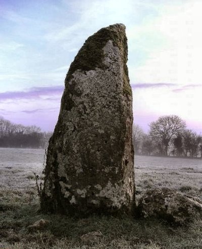
~ 4.8 km NNW in Snimnagorta (N 209 475), 1.2 km S by W of Ballymore, is another 'Cloghstuckagh' of similar dimensions to the one at Moyvoughley.
~ About 9 km SW in county Offaly (N 222 339) is another standing-stone at Bolart North, slab-like, in the middle of a field, close to the road and nearly 3 metres high.
This stone has now fallen - click to view. ~ Some 15 km to the WSW in county Roscommon, (6 km WSW of Athlone) in Mihanboy (M 986 403, Sheet 47) is a ruined portal-tomb, originally supported on portals 2.3 metres high, whose backstone has collapsed - thus causing the roof-stone to slide back, taking the door-stone with it.
|