
county list
![]()
|
Turn smartphone to horizontal
view. SELECTED SITES IN COUNTY LOUTH Place-names in italics refer to listed entries. Convert Irish Grid references to Latitude/Longitude |
|
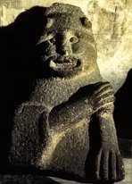
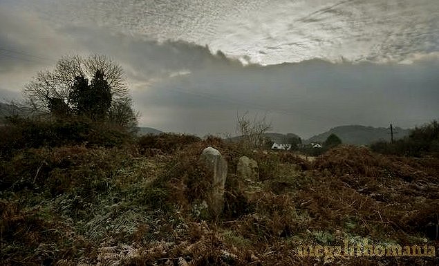
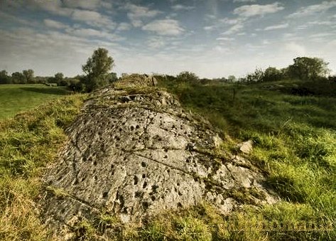
Two interesting, if overgrown, cairns lie some 6.8 km NNE of Dundalk, approachable only from above because a dairy factory blocks the track that leads right to them. About 45 metres apart, one is egg-shaped with a roofless dolmen at one end with portal-stones 2.8 metres high.
At the other end of
this cairn were 6 kist-tombs inserted some time during the Bronze
Age. A paved area close to the N end of the cairn was later
still used for iron-smelting - the sacred site chosen, perhaps,
to give power to the magical metal.
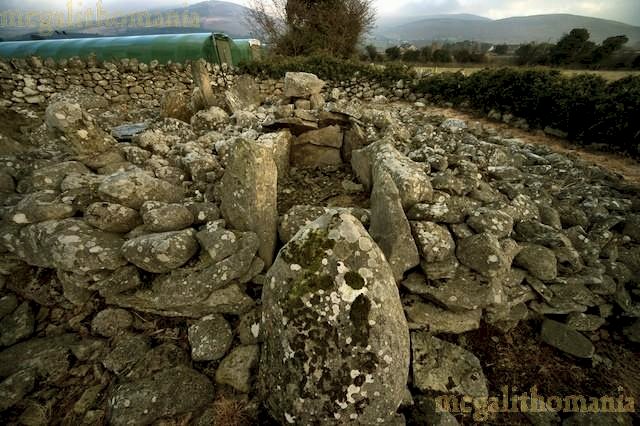
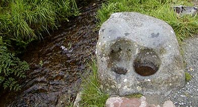
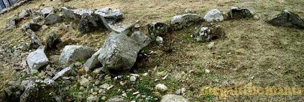
This stone is now known as The Kneeling Stone and visitors/pilgrims kneel in the bullauns to pray. It is also said to have healing properties relating to leg ailments. Next to this, mounted in the wall, is another shallow bullaun which is rubbed as part of the pattern or turas, and nearby is a boulder known as The Horse-Shoe Stone. Between this and and the shrine is a curious anvil-shaped stone - almost phallic and much rubbed around its waist. Rubbing this stone is said to cure stomach (probably originally uterine) problems. Nearby is a chair shaped stone. Lying on this is said to cure back pain (perhaps originally pain connected with childbirth). At the northern extremity of the site (along the stream and across the road), water issues into a basin stone very like those in passage-tombs. ~ 4.5 km SE is Ballymakellett court-tomb (J 099 112), whose gallery is still covered by cairn and grass, and whose surviving court stones reach a height of 2 metres. Next to the southern entrance stone there is just one of the court stones remaining, but the other arm of the court is more intact. Four or five stones remain on this side. In front of these there is a huge slab that at first sight appears to be one of the court stones, but is more likely to be the entrance lintel or a displaced roofstone. A field boundary runs around this side of the monument, which has largely protected this side of the court. The picture below shows the entrance-stones and the overgrown cairn to the left.
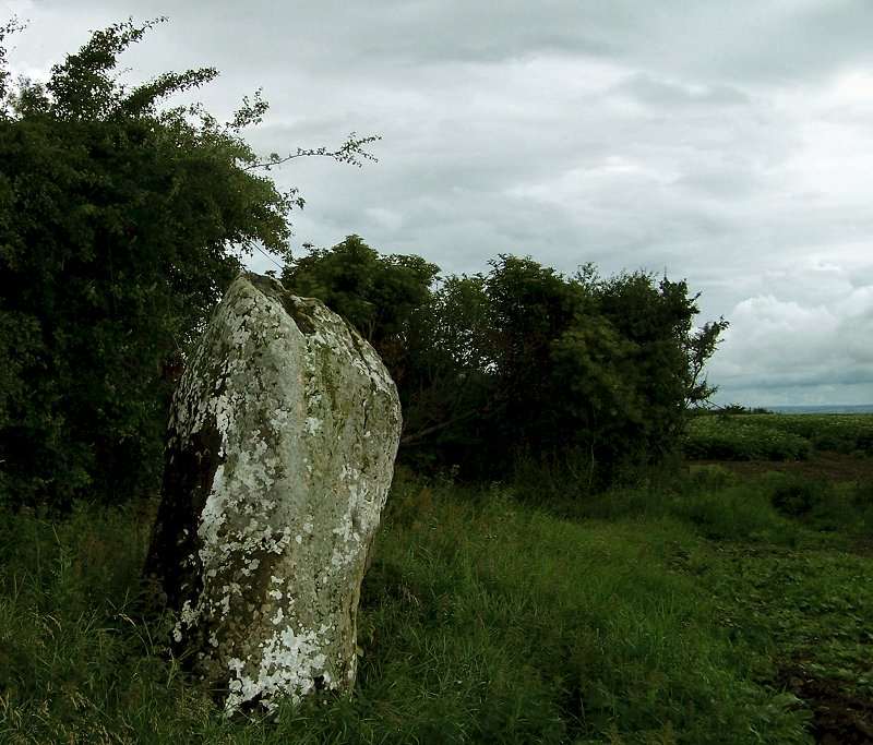
30 metres NE of the tomb is an upright stone, 1.4 metres tall and about as wide, which might be a re-located orthostat from the court. It has a curved edge at the top, with a curious little point at one end, reminiscent of some stones at Ballynoe, county Down. ~ 6.3 km W by N of Aghnaskeagh, in charming Carrif churchyard, Dungooly (J 014 144) is a classic single bullaun by the gate. (Click for a picture.) Ballinloughan:
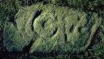
Petroglyphs click
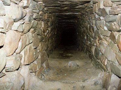
on the thumbnail for a larger picture 1.6 km N of Little Ash, by a stream in the second field (300 metres along a track to the right of a gate) beyond the end of a lane leading NE from the road to Inniskeen from Little Ash, lies a boulder (not marked on the map) with complex motifs of cups and gapped rings. There were originally five boulders here - of which three were wantonly destroyed in 1980. They included a design rare in Ireland: the ring of small cups within a cup-and-ring design (cf Ormaig in Argyll). The pocking on this design and on some of the others could clearly be seen. They were the most interesting and most easily found (!) of a series of petroglyphs in W Louth and E Monaghan. Another stone similar to the one by the stream is now in the National Museum in Dublin. ~ 4.8 km NE in Donaghmore in the sordid garden of a bungalow with maltreated dogs is the only souterrain to be a National Monument (J 009 071 - not marked on the map), an elaborate dry-stone structure with traps, a secret passage and vents, built into a trench dug into boulder clay and, in places, into the underlying silurian grit. The passages and terminal chamber total some 80 metres long, and they are both corbelled and lintelled. Torches will be provided by the guardian who will also unlock the iron doors which protect the entrance. He will say that photography is forbidden, but this is of course untrue. Just under 5 km NNE of the souterrain is the ruined portal tomb at Lurgankeel (see under Proleek, below). ~ 4.5 km SE is the standing-stone at Rathiddy. ~ 3 km WSW in the townlands of Drumirril and (immediately to the N) Comraghs in County Monaghan are over 70 examples of Neolithic petroglyphs - mostly cups-and-rings, but also rare concentric circles - on many stones which are mostly on little heights or mounds. As can be seen from the map, there are many petroglyphs - and souterrains - marked in this area. The most accessible (illustrated below) are at H 936 048. One small mound (with four petroglyphic stones on the top) is surrounded by a ditched enclosure. ~ 2 km E of Drumirril (back in county Louth) is more 'rock-art' at Drumgonnelly (GPS: H 95750 0490), which is so faint that the rings around the cups (most of them natural solution-pits) can properly be seen only when wet.
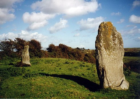
Baltray: Standing-stones W of a track leading N out of the hamlet of Baltray close to a strange concrete structure, are two standing-stones, over 2 metres high, which, it has recently been revealed, align significantly with the Fourknocks tomb in county Meath. Formerly there were three, but the absent monolith has not prevented the discovery that the larger of the two stones aligns with the offshore island of Rockabill towards sunrise at the Winter Solstice. There are also alignments to sunset at Summer Solstice and moonrise at Winter Solstice. photo
by Jim Dempsey ~ 8 km NW (sheet 36) is a fine standing-stone at Piperstown (see under Tinure, below). Hurlstone:
Holed stone 700 metres
down a track leading SW off the R.165, on the SE side of the
track, this superb slab, 1.6 metres high and 1.8 metres broad
at the base, has a perfectly circular perforation roughly in
the middle. It is 20 cms in diameter, splaying to about 25 cms.
This part of Louth used to be rich in standing-stones, and "The
Hurl Stone" is one of a chain of stones possibly forming some
kind of boundary - though equally it might be the only remnant
(a perforated door-slab) of a wedge-tomb. click
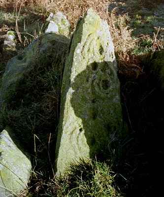
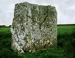
on the thumbnail for a larger picture ~ 6 km ENE in Barnaveddoge, 4 km E of Ardee (O 002 893), is a slightly-leaning menhir, some 2.4 metres high, which stands very close to the N side of the R 170. An ogham inscription reading Branogeni is supposed to be legible down one edge. Three fields to the NE (O 005 896) is another standing-stone, 3.2 metres high, in a dip, and also close to a hedge. These stones have solstitial alignments. ~ 7.3 km S in the middle of a field (H 947 803) in county Meath - and commanding extensive views - is a decorated stone at Mullagharoy whose S face has pecked concentric rings near the top, and natural solution pits. The N side is quite different and extraordinary.
~ 5.9 km W of the Mullagharoy stone on sheet 42 at Rathkenny, also in county Meath (N 888 797) is a collapsed portal-tomb whose large capstone, covered on the upper surface with small grooves and cupmarks/solution pits, leans against a solitary, low orthostat. The underside is smooth except for a series of 7 pocked circles. The inner face of the portal-stone has some two dozen similar circles and other faint scribings.
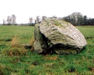
Proleek:
Portal-tomb and Wedge-tomb Approached via Ballymascanlon
House Hotel, and on foot through the stableyard, following the
signs, this fine dolmen, known as The Giant's Load, has
a huge 40-tonne capstone balanced on two portal-stones over
21 metres high and a backstone 1.8 metres high. There may not
have been other stones to complete the chamber. There are always
many pebbles on top of the domed capstone: if one tossed up
does not come rolling down again, the thrower will be married
within twelve months! Close by is a ruined wedge-tomb,
two of whose roofstones survive. ~ 5 km ESE is a very large court-tomb at Rockmarshall, about 50 metres SW of Rockmarshall House and its unattractive outbuildings. It is some 15 metres long, has a broad court of low stones at the N end, and a wide, four-chambered gallery entered through fine jamb-stones and a displaced lintel. Some kerbstones survive on the NW side, and some of the cairn on the SE. However, my colleague, Ian Thompson (whose photographs are below), interprets this tomb as an anomalous double-court tomb, rather than a single-court tomb which may have been added to.
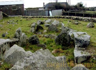
~ 4.5 km N, marked Standing-stones on sheet 36 is an obviously-bogus (but charming) stone circle erected by Lord Clermont of Ravensdale in the early 19th century, and much-photographed by the ignorant. This antiquarian/landscape-architect encouraged his tenants to build sweathouses and corbelled kennels, pigstyes and hen-houses; and he wrecked the passage-tomb known as Clermont Ca[i]rn on Black Mountain to build himself a belvedere. ~ Just under 6 km W by N, behind a squalid farm and shed in Lurgankeel (J 024 116) are the remains of a portal-tomb which must have been even more impressive that that at Proleek. Just one of the portal-stones now stands - to a tapering height of three metres - and a huge boulder-like capstone lies behind it. The original monument would have been over 4.5 metres high. As with Proleek, there is a nearby wedge-tomb. Its remains lie about 150 metres NNW and clearly visible on the other side of the road. Just under 5 km SSW is Donaghmore souterrain (see under Ballinloughan, above). ~ 9 km E in the townland of Commons (J 182 097) are the remains of a court-tomb, consisting of a gallery, aligned N-S, just 1 metre wide and 5 metres long, divided into two chambers by opposing jambs. A field wall runs along the west side of the tomb and across the north end at a distance of 1-2m. Within the base of this wall are several large stones which could be reused court stones. Situated close to the edge of a natural shelf on an east-facing slope, the tomb offers fine views over Carlingford Lough.
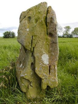
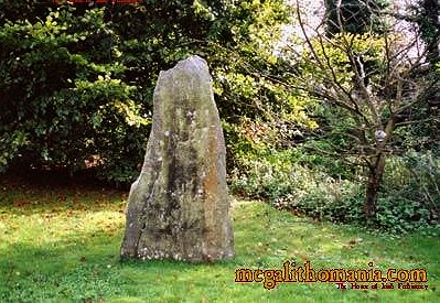
Rathiddy: Standing-stone Next to a stile into the field that contains this menhir is a notice which states that this is "Cú Chuláinn's Stone" - referring to the legendary mindless Ulster macho-hero or demigod who, after being mortally wounded, tied himself to a standing-stone so that he could continue to fight his opponents. No-one dared approach him until a raven (the bird of death) perched on his shoulder, signifying his demise. The stone is over 3 metres tall, 80 cms thick and 120 cms wide at the base, where, in a very clean font and with a good chisel, a certain Jim McKenna - not otherwise known for 'heroic' deeds - has sought immortality. For more on the legends of the stone see Voices from the Dawn. ~ 5.6 km W by S in Monavallet (J 950 029) is another large, but more rectangular, stone, unfortunately fallen and difficult of access. ~ 6 km SE in Whiterath (O 034 983) is a very squat and massive stone only 1.2 metres high. From the road it looks almost cubic, but on closer inspection from the side it is just 30 cm thick at the base. ~ 4.5 km NW are Ballinloughan petroglyphs. Tinure:
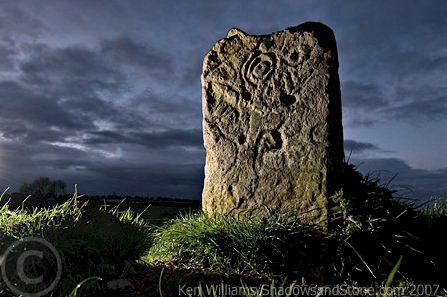
Petroglyphs A scandalously-unprotected and defaced slab over 2 metres high and 1.5 metres wide, partly-obscured by brambles, lies 70 metres N of the by-road from Tinure Cross to Kieran's Cross. It is not marked on the map. The vertical face of Silurian shale is decorated by fine incised lines and tiny punched holes - partly obscured by the initials of vandals. These engravings are thought to be of Neolithic rather than Bronze Age date, and are unique in Ireland. ~ 350 metres S in Paddock (O 050 831) is a low, overgrown wedge-tomb known as "Calliagh Birra's House", with 4 large roofstones still covering the gallery, and 7 transverse buttress-stones, set in remnants of the cairn, on the S side. ~ 3.5 km NE in the grounds of The Parsonage, on the boundary between Parsonstown and Labanstown (O 132 867)is a nicely-landscaped standing-stone 1.4m tall, 80 cm wide and just 20 cm deep.
~ 3.2 km E in Drumshallon (O 083 827) are three standing stones some 2 metres high on the slopes of the outcrop ridge called Carnanbreaga, from which there are fine views as far as the Carlingford and Mourne Mountains to the North, and the Wicklow Mountains to the South. South of these in Piperstown (O 083 837) is another (five-sided) standing-stone which has many solution-pits (some of which may be cup-marks) on its E face. If you stand about six metres E of this stone and shout, the concave face will produce a remarkable echo.
~ 8 km SE of the Piperstown stone are the standing-stones at Baltray (sheet 43). Townleyhall:
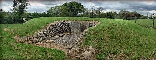
Passage-tomb Part of the Newgrange/Knowth/Dowth complex clearly visible a couple of kilometres to the S in county Meath, this roofless grave is an 'undiffer-entiated' passage-tomb, i.e. with no separate chamber at the end of the passage. Few orthostats survive. Excavators found heel-shaped rows of boulders between the end of the short, wide passage and the kerb, which have been re-covered by the earth and stones of the cairn. The tomb looks like a curious hybrid between the passage and wedge types. Access is via a small stile almost hidden in the bushes along the N side of the N.51.
|
 click for another
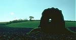