
county list
![]()
|
Turn smartphone to horizontal
view. SELECTED SITES IN COUNTY TIPPERARY Place-names in italics refer to listed entries. Convert Irish Grid references to Latitude/Longitude |
|
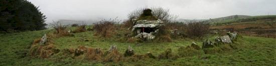
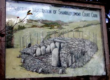
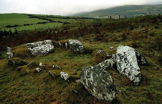
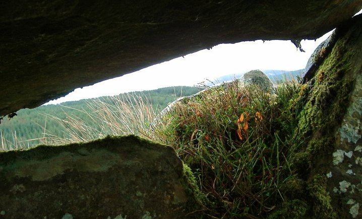
Across 2 fields to the S of a farm lane, 800 metres NE of Rear Cross, this fine and carefully-constructed, but overgrown, Dermot and Grania's Bed has a large chamber over 4 metres long, separated by a septal slab from the antechamber/portico, over which a single-slab roof is supported by 2 free-standing orthostats. The easternmost roofstone of the gallery has a wide, deep groove on the underside, and several of the boulders of the circular cairn (15 metres in diameter) have cup-marked or pocked surfaces. The N orthostat beside the septal slab has a kind of chessboard pattern of incised, criss-cross lines. Excavation revealed that the antechamber was originally open at the W, with a low sill-stone marking the entrance, but this was later closed by double arc of inclined slabs. Inside the antechamber is a roofless kist, which contained cremated bones. There were four other cremations in the antechamber and 16 others in pits and kists in the cairn, some of which were thought to be secondary. The tomb is reputed to have been used as an IRA refuge or hideout during the unrest of the period 1916-1922. ~ 1.6 km E is a standing-stone, and there is another standing-stone 2.8 metres high in the lane near the wedge-tomb. ~ 1.5 km SSW, 400 metres S of Rear Cross, with picnic-tables and Leylandii cypress screen to the W of the road to Pallas Grean (R 842 585, Sheet 66) is Shanballyedmond court-tomb, a southern outlier of the type. To the prevailing wedge-tombs it may owe its small size, U-shaped kerb and narrow, funnel-shaped forecourt. The gallery has two chambers, near which is the kerb of orthostats originally linked by dry-walling. Joining on to the ends of the court - which excavation found to be paved - was a kind of palisade which led right round the tomb over 2 metres out from the kerb.
~ 5.6 km SE in Aughsullish (Sheet 66) are two damaged wedge-tombs. The first, somewhat interfered with by a farm-track and wall (R 877 574) retains its roof-slabs, made level by use of large chocking-stones on the N side.
The second, 150 metres away at R 878 575, is an unusually small example, whose gallery has just two roof-slabs, one resting on the other. ~ 6 km ESE at Loughbrack (Sheet 66) are the ruins of a very large wedge-tomb: see under Knockcurraghbola Commons, below. ~ 6.8 km S by W, is the stone-row at Lackagoneeny, county Limerick. ~ 7.8 km N of Baurnadomeeny
is Bauraglanna stone circle (see under Carrigeen
below). ~ 10.5 km E by N is Knockcurraghbola Commons wedge-tomb.
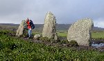
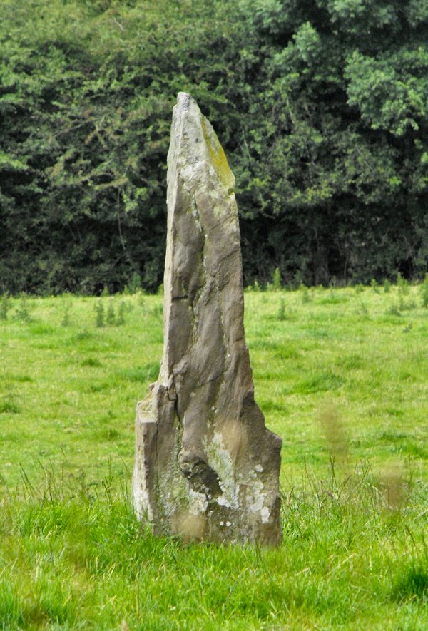
Carrigeen: Stone-row click
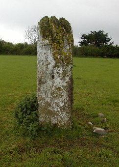
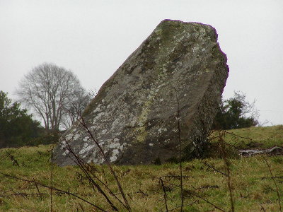
for high-resolution photographs An impressive alignment of three tall, chunky stones commands fine views in the Arra Mountains between Nenagh and the Shannon. The largest, central, stone is 1.7 metres high. The approach can be rough and muddy across farmland. ~ About 11 km E by N, and about 3 km ESE of Nenagh in Lisbunny (R 895 786) is a fine standing-stone, over 3 metres high, with crenellation on the top due to weathering. The stone itself is a reddish conglomerate but it has evidently been whitewashed until recently.
~ 8.7 km NNW of Lisbunny, at Ashley Park (R 874 870,) is an 'undifferentiated' passage tomb - i.e. one in which the passage and chamber are not separate entities. The entrance is around 1.5 metres wide and as the 5-metre long passage goes (NW) towards the rear it widens to nearly 2.5 metres. About 1.5 metres from the rear there is a small stone set against the SW wall, which marks the point where the undifferentiated chamber starts.
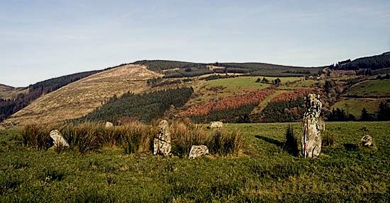
The tomb is to one side of the tumulus, and not in the centre: perhaps there is (or was intended to be) another one. ~ About 12 km SE of Carrigeen at Bauraglanna (R 838 678) is a fine but damaged stone circle sitting on a little plateau overlooking the valley below. It is surrounded by hills on three sides and looks due east along a river valley towards Cooneen Hill. To the southwest the massive Slievekimalta dominates the site.
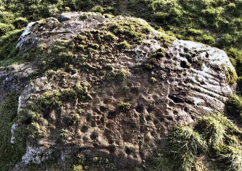
The tallest stone is around 1.85 metres and the shortest is just 40 cm high. It is possible that the stones rose in height as they approached the tallest, but it is difficult to be sure, because so many stones are missing from the NE side of the circle. In the centre there is a fallen stone that may once have stood upright. Interestingly a line from the tall stone through the centre of the circle continues on towards a small notch in the hills to the northwest. ~ At Lisheentyrone (R 762 808) is a pair of low standing-stones (one fallen), but, more interestingly, nearby (R 71684 80784) is a large boulder covered with cup-marks, recently discovered by Derek Ryan.
Gortavoher:
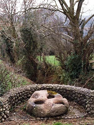
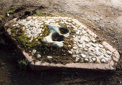
Multiple-bullaun "The Blessed Stone" is a fine, almost circular boulder of quartz conglomerate about 1 metre in diameter lying to the W of "Woodview Farmhouse", which is 5.6 km due S of Tipperary town, in a little modern enclosure on the S side of the by-road from Gransha to Galbally, running parallel with the Aherlow river. It has three large complete bullauns (hemispherical depressions) whose maximum diameter is 30 cms and whose maximum depth is 17.7 cms. Two other bullauns have been eroded by water, and a sixth is very shallow. There are 2 less perfect bullauns on the underside of the boulder, whose name might originally have meant 'The Blessing-stone'.
~ About 19 km SE in Farranagark (S 057 231, sheet 74) in the middle of the road at a junction is a stone with two shallow, roughly carved bullauns - which is painted bright green, although the paint is somewhat worn. It is framed by a diamond of white quartz pebbles surrounded by a curb painted orange. The horse trailers which go around this corner to the nearby stables probably go over this bizarre traffic-island all the time.
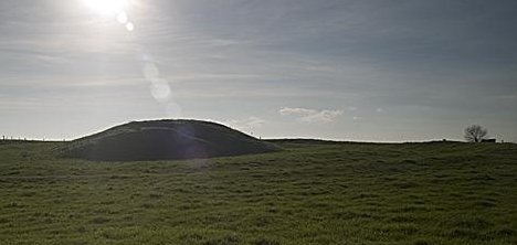
~ 5 km W are the remains of a hilltop passage-tomb at Shrough (R 842 306) - fairly easy to reach via the Ballyhoura Way which goes right past it - thus being possibly the only hill-top passage tomb with a picnic table. The large cairn survives to a height of 1 metre and incorporates an OS trigonometrical marker on the eastern edge. The remains of the small rectangular chamber are set off-centre, and comprise two orthostats on each side, with a half-size orthostat at the W end. The E end is open. Needless to say, there are splendid views encompassing the Glen of Aherlow and the Galty Mountains beyond, as well as the plain of Limerick to the W.
~ 6.6 km W at Corderry (R 826 299) is a seriously overgrown wedge-tomb, on whose gallery two roofslabs remain, while a slightly displaced one lies across a possible portico feature. ~11 km WSW is the passage-tomb at Duntryleague, county Limerick. Knockcurraghbola
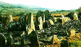
Commons: Wedge-tomb Threee
hundred metres S of the road from Inch to Upperchurch and to
the west of a by-road, this impressive, but partly-ruined wedge-tomb
crowns a knoll which offers fine views of an amphitheatre of
hills. The gallery survives to a length of over 11 metres, with
good double-walling on the S. The façade is missing, but a fine
door-slab remains in position. Two large roofstones are also
in place, covering the SW (front) end of the gallery. ~ 2.1 km SE is a pair of standing-stones just 5 metres from the roadside at Shevry (R 968 596). The smaller one is not quite in the centre of a henge just 5 metres in diameter, with an Eastern entrance, while the larger one (4.1 metres) stands outside. ~ 4.7 km WSW are the ruins of a very large wedge-tomb (Dermot and Grania's Bed) at Loughbrack (R 907 592, sheet 66) whose gallery is over 6 metres in length and 1.7 metres wide, and is aligned with the highest point of the hill to the west (Kilcommon townland). The backstone is almost 3 metres long and spans both the gallery and the double walling. Inside the gallery at its rear there is still some of the inner walling left - the rest is the outer 'skin' of the double walling. There is also a broken slab - possibly a piece of a roofslab.
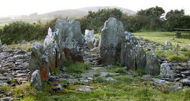
~ 10.4 km W by S is Baurnadomeeny wedge-tomb. ~ 8.3 km ESE is a wedge-tomb at Cureeny (or Curreeny) Commons (R 877 647) which is a very nicely preserved, if remote, megalith, oriented E-W, and with views to the Mahurslieve to the north and Keeper Hill to the SW. It is about a 3 km walk from the house at the start of a lane and consists of a double-walled gallery, at least 7 metres long and 1.2 metres in maximum width, divided by a septal-stone into a portico at the WSW and a main chamber some 5 metres long. The gallery sides decrease in height towards the E. The entrance is formed from two huge megaliths that resemble the jambs of a court-tomb. A small stone set in between them indicates that it had a split portico. Just one roofstone is still in place, but the quality of the double walling and the two entrance jambs, one of which leans outwards, make up for that. There is also a fallen jamb inside the gallery, which would have only blocked off half of its width. This, like the huge entrance stones and the tapering gallery, gives this tomb a passing resemblance to a court tomb. Timoney
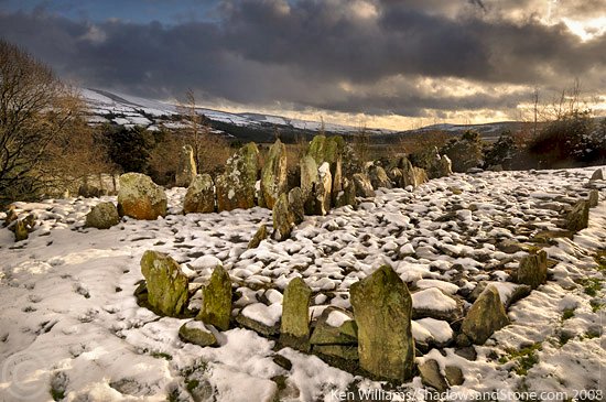
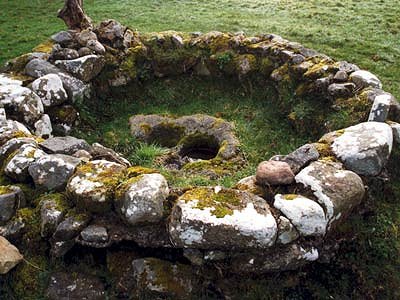
Hills: Standing-stones and alignments About 8 km SE of Roscrea, scattered over an area of 40 hectares of fields and woodland in Cullaun and Timoney Hills townlands, county Tipperary, and extending into Laois, are some 300 enigmatic, small Standing-stones which (except for a circle of 16 stones with a diameter of nearly 70 metres in Cullaun) form no discernible pattern nor as-yet-imaginable function. Some are in groups of three: a tall stone, a short stone and a slab. Others occur singly (especially to the N) or in pairs. A note on access from The
Standing Stone website:
|
