
county list
![]()
|
Turn smartphone to horizontal
view. SELECTED SITES IN COUNTY KERRY Place-names in italics refer to listed entries. Convert Irish Grid references to Latitude/Longitude |
|
Ardamore:
Stone-row
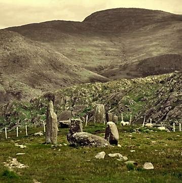
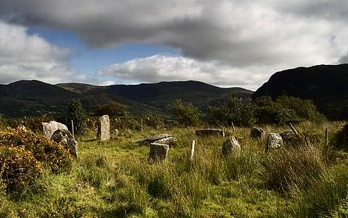
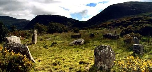
Q 523 000 Sheet 70 400 metres N of a by-road, and 7.5 km E by S of Dingle, the highest stone of this 3-stone row (plus outlier with petroglyphs on it - on the far right of the photo below ) is 3 metres.
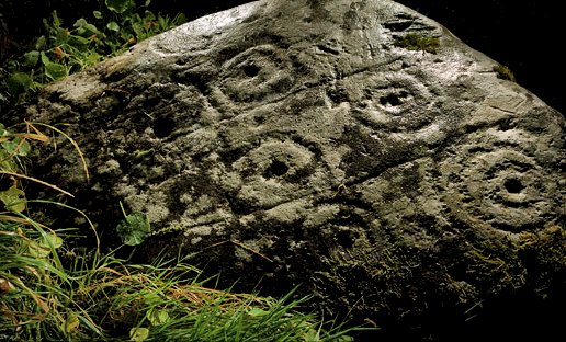
~ 500 metres SW of the Ardamore alignment, in Aghacarrible (V 511 997) 20 metres S of a by-road, in a field entered by the leftmost of two field gates, and on either side of the right-hand field-fence, is a large boulder with cups and rings, gutters, and other typical petroglyphic designs.
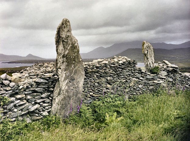
~ 700 metres SSW in Doonmanagh (V 525 996), 150 metres W of a rough track zig-zagging down towards the sea, is a wedge-tomb, lurking behind a wall about 300 metres SW of a radio transmitter, but visible from the road which passes the mast. "Poukauncorrin" (The Fairies' Cave) is a small well-preserved tomb. At least one sidestone has been removed from the NW side, together with some of the cairn, to provide access and make the tomb a snug shelter or habitation (cf Haroldstown in county Carlow). The site affords superb views to the W and NW, and to the E and SE towards Magillicuddy's Reeks. ~ About 400 metres NE of Doonmanagh, to the N of the narrow winding road which passes the transmitter in Graigue (Q 532 003), is a remarkable tall standing-stone split vertically in two, one piece leaning on what appears to be the remains of a second stone.
~ 6 km W by S in Ballintaggart (V 464 997), about 300 metres S of the Anascaul-Dingle road, is an ancient circular enclosure on the top of a knoll, containing nine smooth, cigar-shaped pulvinar stones from Minard - three of them christianised with crosses. They have various ogam inscriptions, including one reading TRIA MAQA MAILAGNI (The three sons of Malagnos) with CURCITTI on the back, and a cross with triple ends - which is the Icelandic End-Strife pictogram.
Another reads CUNUMACCQQI AVI CORBRI (Conmac, grandson of Coirpre). Another reads NETTA LAMINACCA KOI MAQQI MUCOI DOVIN[IA]S (The nephew of Laminacca, the son of the people of Dovinia), and has a cross with expanded terminals. Dovinia was the ancestral goddess of the Corcu Duibne after whom comes the other name of the peninsula: Corcaguiny. Another of the stones also mentions the goddess in its inscription MAQQI IARI KOI MAQQI MUCCOI DOVVINIAS. It has been suggested that the duplication of consonants was a ploy by literate stonegravers working on piece-rate to cheat their illiterate employers.
~ 9.5 km W by N, 800 metres ESE of the village of Milltown (Q 429 010), almost opposite the graveyard and to the W of the road from Dingle to Ventry, on top of a low cairn is a boulder almost 4 metres long, decorated with cups and circles and grooves. Nearby are standing-stones, and another boulder with markings. To the N are the two 'Gates of Glory' standing-stones (one broken), and 40 metres W, close to the road in the garden of Milestone House B & B is another standing-stone 2.4 metres high known as Gallán na Cille Brice and 'The Milestone'.
~ 20 km W by N, in another townland called Graigue (Q 316 029), close to Clogher Head and visible to the NW of the R.559, is a handsome standing-stone less than 2 metres tall, but from which is a spectacular view NE towards Mount Brandon. ~ Slightly over 10 km W by S in Burnham, (V 421 998) in the grounds of the Earl of Ventry's former residence of that name, now a college (Coláiste Íde), are seven ogam stones of which 5 are erect and two are recumbent and cigar-shaped as at Ballintaggart. Nearby are a small cross-slab and small bullaun. Most of them were brought here from Kilrannig (see under Dunbeg, below).
~
Just under 2 km E by N in Lugnagappul (Q 542 003),
marked Clocha Ogaim on the map, in a field close to
the road called "Pairc na Foladh": the Field of Blood, is
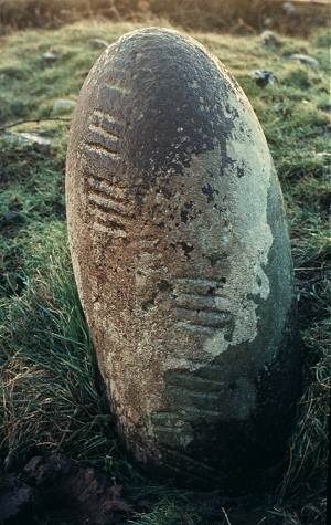
a line of three remarkable Ogam stones which are small, smooth
pulvinars, one of which is beautifully egg-shaped and reads
GOSSUCTTIAS. As is frequently the case
with Irish monuments, there are white quartzite
pebbles at the base of the stones.
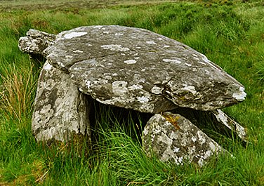
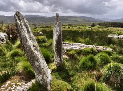
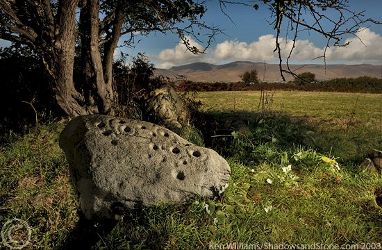
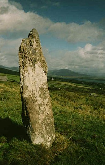
~ 4.4 km WNW of Ardamore in Ballineetig (Q 478 008) is "Gallaunmore"(An Gallán Mór) a Standing-stone some 5 metres high. ~ 10.7 km WNW in Kilfountan (marked Gallán on the map at Q 425 035) is a fine conspicuous standing-stone, visible from the by-road to the E, and from the Early Christian site (350 metres SW) with a superb cross-decorated pillar which bears the name of the saint: Finten. ~ Just over 3.5 km NNW of Kilfountan is the well-signposted monastic site of Kilmalkedar. A short way along the road to the W of the churchyard, on the right, is a kissing-gate. In this field a Fogra sign is visible atop a boulder some 2.5 metres square: a six-basin bullaun, one of whose depressions is nearly 50 cms across, and another one which is shallow and probably unfinished. The rod in the photo below is a metre long. This bullaun is known as The Keeler's Stone, and is connected to the legend of Glas Gaibhnenn (see below). Very close to the Keeler's Stone another - single-bowl - bullaun, was found during road construction in 1984. It is now set in an upright position next to a wall on the west side of the road. ~ 5 km SW of Kilmalkedar (Q 357 038) in Ballyferriter, to the E of a by-road above Ballyferriter, is the 'Gate of the Cow' (Geata an Ghlas Ghaibhnigh), a pair of standing-stones some 4.2 metres apart. Cattle were presumably driven through the gap (now filled by a wall) to ensure fertility. The folklore associated with the magic cow, the pillarstones and The Keeler's Stone can be read on the Voices from the Dawn website. The museum in the old schoolhouse at Ballyferriter is well worth a visit. ~ 5.6 km S of Kilmalkedar (Q 391 010) in Caherard, is a handsome little wedge-tomb known as Leaba an Fhir Mhúimhnuigh or 'The Munsterman's Bed', from which there are splendid views. ~ In Ballyhoneen in the middle of the peninsula, some 8 km SW of Stradbally via the R560, on the highest point on a low ridge to the east of the Scorid river (Q 528 082, sheet 70) is a handsome wedge-tomb with a narrow, four metre long wedge-shaped gallery 4 metres long, with two overlapping roof stones. Three of the stones of the gallery have engravings including a cup-and-ring, twelve shallow cup marks running along the western edge of the east roof stone, and perhaps two other cup-marks. Daithí Ó Conaill reported that this wedge tomb is aligned to the setting sun of the equinox. From one angle it looks like a large tortoise. Below it at Q 527 083 is a fine triangular, thin, slightly leaning standing-stone which you can see by clicking here. It may be a roof-slab from the tomb. ================= The Dingle (or Corkaguiney) Peninsula is littered with Standing-stones (marked Gallán [singular] and Galláin [plural] on the map), as well as a rich variety of Early Christian sites with cross-pillars, Ogam-stones, cross-slabs, circular stone huts [Clocháns] etc. Almost all are clearly marked on the map. Two more sites at the Western end of the peninsula are Dunbeg and Kinard East, listed separately below. Aughacasla
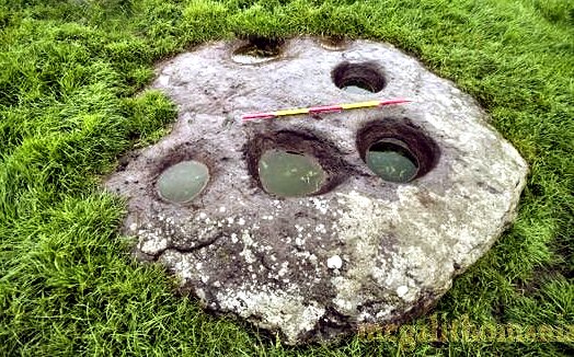
North: Standing-stone Behind a cottage just S. of a caravan park, some 250 metres from the shore, is a fine standing-stone which has been altered in recent times to produce an anthropomorphic figure some 3 metres high. The cement-alterations are now starting to flake away, making the stone a remarkable piece of anonymous sculpture (modern 'folk-art') almost on a par with Celtic carved stones. Ballynahow
Beg: Petroglyphic boulder Behind a house to the
S of a by-road, 7 km NE of Cahirsiveen (marked Rock Art on
the map), in the second field (50 metres) from the road, to
the W of a hedge and bank is a boulder whose exposed E face
is 135 cm long and 81 cm high, decorated with Bronze Age motifs
such as ringed cupmarks with 'tails' or 'gutters' (looking a
little like frying-pans with fried eggs), un-ringed cupmark,
and a grid of grooves. It is unusual for petroglyphs to be carved
on the vertical face of a boulder. ~ 4 km ENE, to the E of a by-road in Gortnagulla (V 567 836) is a row of 3 stones, one of which has fallen.
~ Almost 11 km ENE are the petroglyphic outcrops at Kealduff. ~ 25 km ESE are several petroglyphic boulders at Derrynablaha. ~ Almost 10 km WSW is Leacanabuaile stone fort and other forts nearby. Coom:
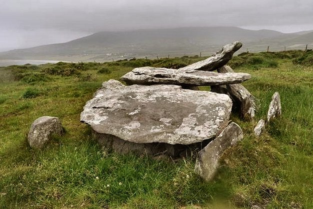
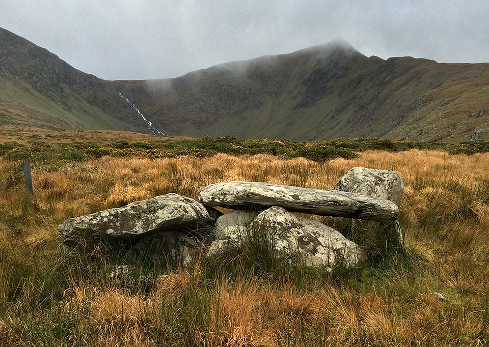
Wedge-tomb, etc. The picturesque "Labbydermot"
lies 200 metres S of a road-junction, 3.3 km NW of Ballinskelligs.
This well-preserved and picturesque tomb's main chamber is covered
by a capstone just under 3 metres long. There is an opening
in the narrow E end which may be original. The antechamber/portico
is unroofed and made with high slabs, the largest being 1.5
metres high. There are two closing-slabs with a deliberate gap
in the N side. Derrynablaha:
Petroglyphs 1.5 km
E of Lough Brin, scattered over a wide area to the E and W of
the road through the beautiful Ballaghabeama Gap, and surrounding
the only inhabited house (in 1975) for miles, are over 20 decorated
rocks. They are very difficult to find on the boulder-strewn
hillside, but perhaps the easiest to locate are those for which
the grid reference above is given, found by following the S
branch of a stream from the bridge about 300 metres S of the
abovementioned farmhouse, then up the hillside for about 400
metres. A prominent table-like rock a short distanced S (left)
of the stream - and visible from the road - is decorated with
numerous cups and penannular rings and grooves. beside it is
a small rock whose vertical (W) face is decorated with the rare
motif of cups and rings surrounded by a ring of small cups and
a large indented ring, similar to those at Ormaig in the Kilmartin
Valley of Argyll.
About 200 metres E
of these, about halfway between them and the second bridge (200
metres SE of the first one) is a low altar-like rock with a
curious design of cup-marks and irregular, roughly-circular
grooves. ~ 9.7 km SE (6.4 km WNW of Kenmare at V 848 734) just 20 metres W of a by-road, in a field just S of the (?former) Downings' house at Poulacapple in Rossacoosane, is a single boulder (not marked on the map) with a curious and interesting pattern of grooves and cups & rings. Dromatouk:
Stone circle, etc. 4.8 km ENE of Kenmare and about 350 metres above the road which follows the Roughty river on its S side, is a neat little 5-stone circle. 220 metres SW is a low cairn some 7 metres in diameter with a single pillarstone 3 metres to the N of it. 400 metres NE of the cairn is a group of three standing-stones not in line, the highest and midmost bearing on its cracked and fissured surface an Ogam inscription which has been interpreted as TAGNILOCID MAQI ALOTTO.
~ 5 km ESE is the stone circle at Gurteen. Drombohilly
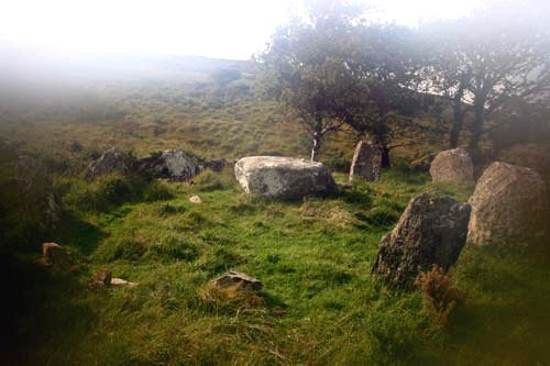
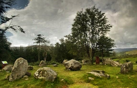
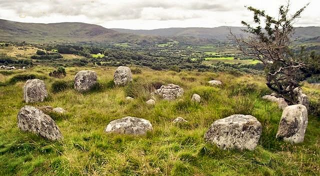
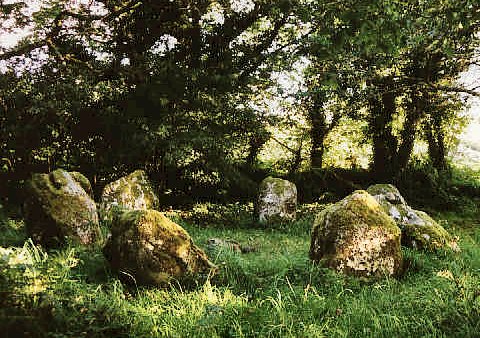
Upper: Stone circle 2.4 km NE of Lauragh Bridge and 350 metres E of a by-road from which it is visible, this fine stone circle crowns a knoll and offers magnificent views. It is unusual for the pillar-like stones used in its construction. Nine stones out of a probable 11 now remain (one of the missing stones being the 'axial' or 'recumbent'), enclosing an area over 8 metres in diameter. A short distance to the E is a rectangular grass-covered stone-built mound which may have something to do with the circle. ~ Just over 200 metres S in the same townland is a very neat little wedge-tomb (V 789 606) still partly-buried in its cairn, which has some fine quartz pebbles on top. The door-slab has been pulled aside. ~ Slightly over 5 km SE, in Glanrastel in the midst of the Caha Mountains (V 828 576), is a remarkable set of petroglyphs dating from neolithic rather than Bronze Age times. They are more extensive and better-preserved than those at Tinure, county Louth, but very difficult to find. ~ 5.6 km SW, in Cashelkeelty East (V 748 575) , 800 metres S of the Lauragh-Castletownberehaven road and 3.2 km WSW of Lauragh Bridge, up a forest track and past a beautiful waterfall, the remains of a 5-stone circle beside a rock outcrop eventually, suddenly and dramatically come into view. The two portal stones of this little 5-stone stone circle are missing.
Immediately S of the circle are 3 outliers from 1 to 3 metres tall, in a line over 6 metres long. The site, as is to be expected, commands impressive views. To the S and E are traces of prehistoric field-walls. 150 metres W are remains of a probable stone-row, also set significantly beside a rock-outcrop. My colleague Ian Thompson remarks that the stone-row has "a rather unique design feature. The tallest stone (2.5 metres tall) is a flat slab, but its axis is aligned neither with nor at right angles to the axis of the row. It is instead aligned to the axis of the long rocky outcrop that is next to the stones. The axis of the row is NE-SW with the tallest stone at the NE. This line points to a notch in the nearby skyline." Two stones
20 metres to the N may be the remains of another circle. Immediately
N of these sites, the mediæval road from Kenmare to Castletownberehaven
is still discernible as a wide, grassy track. Close to the car
parking area next to the muddy forest path up to the circle
are two standing stones (V 755 578). The smaller one is just
1 metre tall and leans. The taller stone is about 1.4 metres
tall. The backdrop of tree trunks makes them quite difficult
to discern. ~ 6 km NE, in a beautiful setting between the two loughs of Cloonee and Inchiquin at Uragh (V 832 625), is a fine 5-stone circle, with a blade-like axial stone and a huge outlier 3 metres high. It affords splendid views, as does the second stone circle in the townland (V 825 630), 800 metres to the SW. Difficult to find among the bushes, eleven low stones surround a central boulder-burial. Outside the circle are two more boulder-burials.
~ 6 km SW is the fine circle at Dromroe (V 882 658). ~ 4 km SSW is a rare Irish "four-poster" stone circle mysteriously hidden in a grove on the island of Knockcappul in the Kenmare estuary (V 768 577). It is accessible only at low tide. A gallows stood here also in the 18th century. ~ 6.4 km SW of Dromobohilly and 2.4 km SSE of Cashelkeelty is another stone circle dramatically situated in Shronebirrane (V 753 554). Some 7 metres in diameter, it is 4.8 km SW of Lauragh Bridge and visible to the right of a road leading up a dramatic glen towards Eskatarriff and The Pocket. Eight tall stones out of a probable 13 survive, set unusually close together. Opposite the tallest (entrance or portal) stone is the axial stone, with a straight top edge. The other entrance-stone is missing. A bungalow has been built right beside the circle, and the owners have been attempting to charge money for access, which may be linked to the signposting of the monument. ~ 8.3 km (WSW) at Glashananinnaun (V 719 565) is a stone circle reminiscent of the 'coves' of Stanton Drew and Avebury in England, now comprising 3 large and equal slabs measuring 1.8 metres wide by at least 1.6 metres tall, set at right angles to each other to form three sides of a cube. They are too far apart to be the sides of a tomb-chamber. ~ 9.6 km SW is the superb circle at Ardgroom Outward in county Cork. Dromroe:
Stone circle and Boulder-burial About
5.6 km SW of Kenmare, approached via a track leading
SW from a by-road, above a farm, a very picturesquely-sited
circle encloses an area over 9 metres in diameter. Three of
the 13 stones (including one of the entrance- or portal-stones)
are fallen. In the centre is a boulder-burial
set with its long axis coinciding with that of the circle whose
flat-topped axial or recumbent stone is at the SW. The three
supporting stones are also flat-topped, and between them and
the large covering-stone are chocking-stones. Nearby is an unique
internal monolith. ~ 8.3 km ENE there is the stone circle at Lackaroe - see under Gurteen (below). Dunbeg:
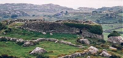
Promontory fort click
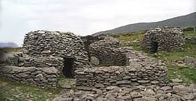
on the thumbnail for a larger picture 3.2 km E of Slea Head on the Dingle Peninsula, and S of the road in the townland of Fahan, across a field, this fine fort is a triangular headland defended on the landward side by a massive, restored dry-stone wall with elaborate entrance and internal terraces, and to seaward by high, eroded cliffs. The side-walls of the long, lintelled entrance are recessed to hold sliding defensive beams, and have guard-chambers on each side with squint-holes for surveillance of the passage. From below the passage a long souterrain leads out at least as far as the second of 4 parallel defensive stone-faced banks with ditches. Inside the fort are remains of a large circular stone hut (clochán) with a square interior. From it a stone drain leads to the cliff-edge, where some traces of a curtain-wall survive. ~ Between Dunbeg promontory fort and Slea Head are many stone forts containing circular stone huts or clocháns of one, 2 and 3 chambers, especially in the contiguous townlands of Fahan and Glenfahan. Unfortunately, many locals are charging the unwary to cross their land to see them, as is the case with the one illustrated here.
Others are demolishing forts which are on land they have recently acquired, as scandalously happened with the huge promontory fort, Dún Mór (V 305 982), overlooking the Blasket Islands. The best of the forts is Caher Murphy, 400 metres W of the ford and about 100 metres N of the road at a little lay-by. One of many forts to fall victim to fanciful Victorian restoration, it is still well worth visiting, and contains five contiguous circular huts. In the floor of one is an entrance to a souterrain.
Eightercua:
Stone-row On the crest of a ridge to the E of the main road 1.6 km SSE of Waterville, 4 tall slabs from 1.8 to 3 metres high run from E to W. From one of these an orthostatic slab runs S and looks like part of a tomb-chamber or a kist set in an oval cairn 1 metre high. The association of standing-stones with cairns is not uncommon in Kerry. ~ An "unclassified megalithic tomb between the Finglas River and the sea" in Ballybrack is known as Ballybrack Dolmen. ~ 3.3.km S is Loher stone fort or cashel (V 506 615), whose walls survive to a height of over three metres and are 3 metres thick, sloping nicely inwards as they rise. On climbing the internal stairs (restored) you can see how well they are built. The inner and outer surfaces are finely built with dry-stone techniques and the gap between is filled with loose rubble. There is a single massive doorway leading through into the inner area with the remains of two houses, one rectangular and one circular, with walls surviving to 1.5 metres. The site is protected on three sides by high mountains, and the views are spectacular. To the west there is plenty of good land and, beyond that, Ballinskelligs Bay. The fort is well-placed to see any vessel that might come in to land. ~
4.4 km S by W of the Eightercua stone-row is Coumatloukane
"Boardeen" - see under Staigue. Feaghna:
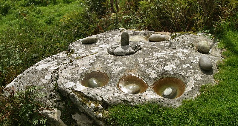
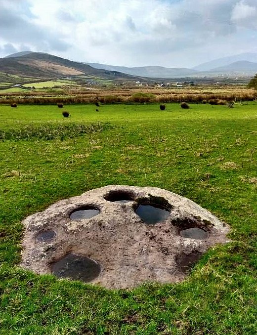
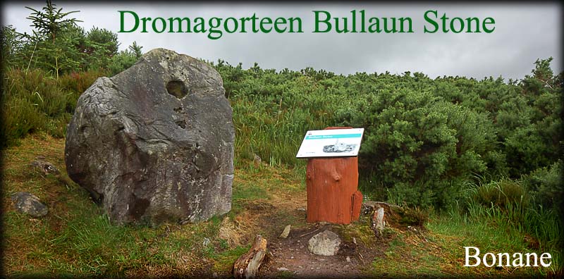
Bullaun 8.8 km SE of Kenmare,
to the S of a ruined church which is to the N of a by-road is
a remarkable smooth-topped boulder with 8 hollows in it, ranging
from small cup-marks to hemispherical basins about 30 sms across.
The larger ones carry oval stones latterly known as 'butterlumps'
. These are turned in their basins in the final stages of the
Easter 'pattern' or 'turas' which includes a well to
the E of the church, and part of the church wall. The 'patrún'
or 'pattern' is evidently of extreme antiquity - as indeed
are most in Ireland - going back at least 2000 years. In the
middle of the boulder a cylindrical stone of phallic shape stands
in a circular holed stone. ~ 1.6
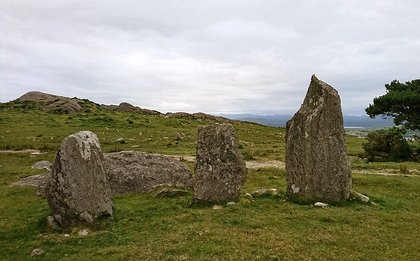
km NNW (inside the Bonane Heritage Park: entrance 4 euros
in 2008) is Dromagorteen stone circle (V 959 653), comprising
13 stones with one of the portal stones fallen. The axial stone
is not as obvious as usual. This well-preserved monument is
somewhat ruined by the proximity of the information boards,
which are mounted on tree stumps that have been stained a foul
vivid orangey-brown colour.
~ 9 km WNW is Dromroe stone circle. ~ 12 km SSE in county Cork are Mill Little stone circle and boulder-burials. Gurteen:
Stone circle 9.5 km E of Kenmare and 3.2 km S of Kilgarvan, to the S of a track, on a ridge to the N of the Glashagoruv river, the eleven stones of this circle (10 metres in diameter) are set in splendid landscape. The large axial or recumbent stone has a bevelled top edge. Opposite it, two portal-stones lurch to the E. A large boulder stands in the middle: the capstone of a boulder-burial. Two stones stand outside the circle to form a kind of approach-passage, as at Gowlane North in county Cork.
click for pictures by Ken Williams ~ 4.8 km WSW at Lackaroe (V 958 688) is another fine stone circle, rather harder to reach and involving a 750-metre walk up a steep and boggy hillside. It is almost complete with just a few fallen stones, situated typically on a small plateau on the hillside that offers wonderful views to the east.The stones are grey, whereas all the rock outcrops in the area are a reddish colour. This gives the impression that they were brought in from elsewhere. If the stones themselves, along with the twisted thorn-tree that grows next to one of them, were not splendid enough, the other features of the monument make this a very special and possibly unique structure. In the centre of the 10-metre-diameter circle there is a boulder-burial enclosed by a smaller inner circle of stones.
~ 5 km WNW is the five-stone circle at Dromatouk. Kealduff:
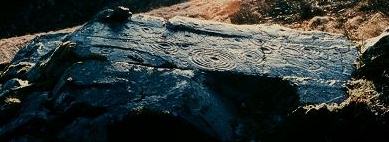
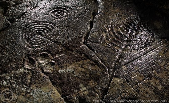
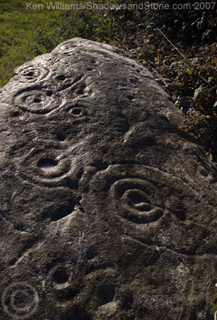
Petroglyphs Apparently around 19 examples of rock art have been recorded in this townland alone, with two more in the adjacent townsland of Letter West. Because many were almost entirely covered in peat they have been amazingly well preserved, in dramatic contrast to the weathered carvings which have been visible for centuries. There are some unique cruciform designs with cups and pennanular rings at the end of each arm, and sometimes inside the remaining 'slices' of the axis. The picture below is of panel 331 as numbered by the Archaeological Survey of the Iveragh Peninsula. ~ A short distance S, at Coomasaharn (V 632 852), near the N end of the lake of the same name, are several horizontal rock surfaces decorated with circles, lines, cups and rings. The best surface is 100 metres W of a modern bungalow at the end of the tarred road. ~ 2.5 km N in Coolnaharragill (V 633 886) in the front garden of (the former ?) Jackson's guesthouse to the S of the Cahirsiveen-Killorglin road, is a boulder decorated with cups and rings.
In the same townland is a stone fort or cashel with an S-shaped souterrain. ~ 19 km NE of Kealduff in a cillín (killeen) at Ballykissane, NNW of Killorglin (V 773 980) is a petroglyphic boulder. A cillín (misleadlingly meaning 'little church') is a burial ground for infants that died before baptism, and were buried away from the consecrated graveyard alongside others deemed (contrary to the New Testament) to be beyond 'salvation'. My colleague Ken Williams reports that "A very nice woman who lives nearby nearly had tears falling when she was describing how grief-stricken parents of infants were forced to bury their children after midnight in this graveyard away from the community, and could not wake them or find comfort in the normal burial rituals". This cillín was, horrifically, in use up until the mid 20th century, its graves marked with rough stones and bits of boulder. Recently, perhaps in a hypocritical moment of cheap repentance, a standing stone with a memorial plaque for the children buried here was erected where the old track to the burial ground met the road to the East. The rock art is now sitting under a tree along the borders of the raised burial area but has been moved at least once. Along both sides of a fissure are five cup and rings and around 12 deep and rounded cup marks. Other rings may have weathered away.
Access is by permission through a farmyard along the road south. ~ Almost 11 km WSW (sheet 83) is the petroglyphic boulder at Ballynahow Beg. Kenmare:
Stone circle and Boulder-burial On the SW outskirts of Kenmare, 600 metres SW of Cromwell's Fort (a 17th century castle), stand fifteen stones (two prostrate) which enclose an oval area over 16 metres across, in the middle of which is a good example of a boulder-burial comprising three small stones and a large capstone. Recently, outrageously, this fine circle has been incorporated in an expensive private garden! ~ 3.2 km NE of Kenmare in Gortagass, down a lane to the NW of the road to Kilgarvan, just on the other side of the dismantled railway is Cloch a Caipín, a presumably natural curiosity (not marked on the map). A very large round boulder sits neatly on a large cylindrical boulder - resembling a giant mushroom. Kilcoolaght
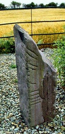
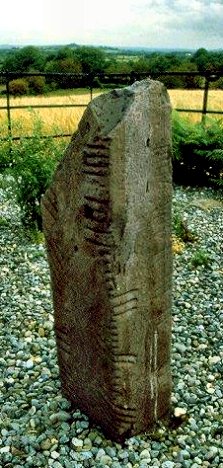
East: Ogam stones A little more than half-way between Beaufort and Killorglin there is an enclosure containing six re-erected ogam stones: broken sandstone pillars, rectangular in plan, with deeply-incised inscriptions.
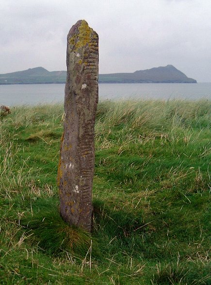
Kinard
East: Ogam Stone Half-buried at the W end of the old graveyard is a rounded pulvinar stone similar to one of the stones at Lugnagappul (almost 5 km ENE). On the side is a well-cut Ogam inscription reading MORIANI, while on the E face is a large square divided by a cross. My colleague Tom FourWinds reports, however, that the stone cannot now be found. ~ About 250 metres SE of the pulvinar, in the second field above a group of cottages to the right of a track, is a stone - some 3.5 metres long - decorated with grooves and cups, many with rings. During field clearance it was moved to the edge of the field so that the petroglyphs were invisible and protected on the lower surface. My colleague Tom FourWinds visited it in 2007, by which time it had been turned over, so that the petroglyphs are weathering. The photo below was taken by Ken Williams on the same visit.
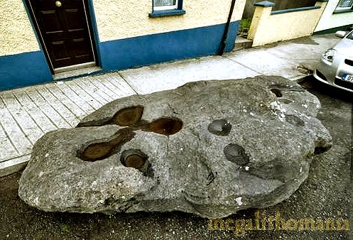
~ 5.6 km WNW at the top of the High Street in Dingle town, is a boulder over three metres long, looking as if it had been dropped from the sky, washed up by the sea, or parked there like a car. It has four large bullauns at one end, three of which are interlinked by shallow channels. Close to these are two very small depressions. At the other end there are several natural-looking rough cups.
Leacanabuaile
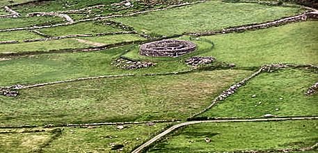
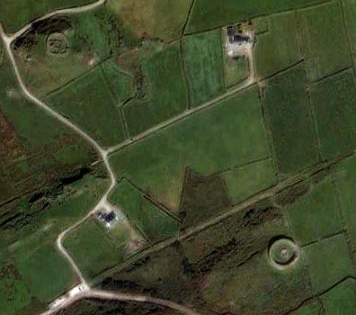
Stone fort Prominently sited on top of a massive rock, 3.2 km WNW of Cahirsiveen, this fine stone fort has a reconstructed dry-stone wall 3 metres thick (but now only 1.2 metres high), adapting to irregular outcrops of rock. There is a wall-entrance on the SW and remains of 2 terraces on the NE. Steps lead up to them at 10 points. There were formerly 3 beehive-shaped huts inside, but only one survives, with a (later) square house built against it and on top of the ruins to two other houses. The round house abuts the wall of the fort, and from its doorway a hole in the floor leads into a souterrain some 10 metres long, ending in a wall-chamber. There is another wall-chamber, entered by a short passage, in the NE part of the wall. On the aerial view below, Leacanabuaile is top left and Cahergal bottom right.
~ 300 metres N of Leacanabuaile is another stone fort called Cahernagat (Cathair na gCat). ~ 400 metres SE of Leacanabuaile is Cahergal, a fine but ruinous stone fort, in the centre of which is a large oval dry-stone house with walls surviving to a height of 1.5 metres (see photograph above). ~ Just over 8 km SW, in Cool East (V 373 755) on Valencia Island, N of the northern (minor) road leading SW from Knightstown to Bray Head, is Killadreenagh, an ancient burial ground with an Ogam pillar some 1.9 metres high, engraved with a Latin cross. About 100 metres NW of this, on higher ground,
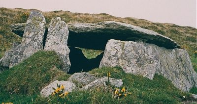
is a low wedge-tomb with a portico and a single capstone measuring 3 by 2.5 metres. South of the road is another Ogam pillar, and there are several pillarstones and an alleged (but dubious) stone circle in the landscape to the E and S, of which one handsome (but unidentified) monolith is illustrated here.
~ Almost 10 km ENE are Ballynahow Beg petroglyphs. Lissyviggeen:
Stone circle and outliers Only 3.2 km E of Killarney, this too-well-known seven-stone circle within a low surrounding bank of earth (beyond which stand two large outliers) is closed to casual visitors, due to the amount of litter and other depredation. Serious visitors can obtain permission. click
for a high-resolution picture Shrone
Beg: 'City or Citadel of Shrone': Stone fort, Cross-slabs, Kist
and Holy well. The earliest
part of the site (in continual use for millennia) is probably
the remains of a megalithic kist in the middle. Today a pattern
is still observed at the holy well and cross slabs. There
are several ruined farm buildings on one side of the inner ward,
indicating that the cashel was used as a farm yard/homestead
at some fairly recent point.
On the other side of the cashel interior there are two pieces of of exposed bedrock. These too have engraved crosses that get the same treatment as the cross slabs. The site is overlooked by The Paps of Anu, two of the most sacred hills in Ireland, each nicely nippled with cairn on the top. ~ 13 km SSE is another ritual site at Ballyvourney (county Cork). Staigue:
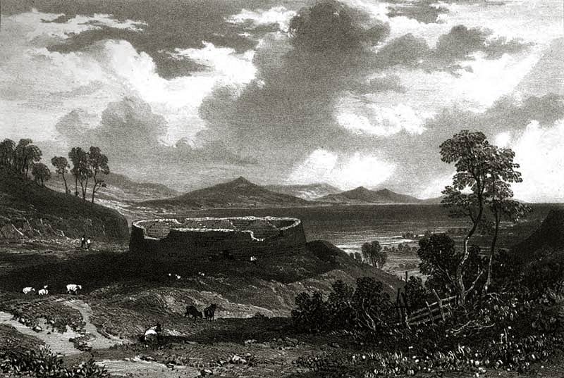
Stone fort and Petroglyphs This well-known and restored fort 27 metres in diameter, a few km SW of Sneem, is splendidly situated at the head of a valley opening S to the sea., and is surrounded by a ditch over 8 metres wide and, at present, 1.8 metres deep. The massive wall reaches a height of almost 5.5 metres and is about 4 metres thick at the base, tapering to about half as thick at the top. Vertical joints in the walls show that gaps left to allow access of carts etc. during building were filled in later. The doorway is tapering and lintelled. Inside is an elaborate system of stairways leading to terraces, and corbelled cells in the wall reached by passages. Read more about the recent history of the fort on the Voices from the Dawn website.
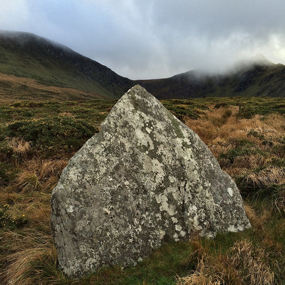
click for a view in 1830 by Robert O'Callaghan Newenham ~ About 800 metres S of the fort and about 100 metres E of a disused bridge (beside which the road bends to the W) is a large outcrop of rock, visible from the bridge. On it is a fine series of cups and circles and grooves extending for 12 metres along the rock surface. ~ 7.2 km SW, just 800 metres W of Caherdaniel hamlet and about 200 metres W of the road to Waterville is another stone fort, beautifully situated on a commanding outcrop of rock, whose switchback irregularities make the construction most impressive. Its walls are up to 4.5 metres high and enclose an area 25 metres in diameter. ~ 1.5 km SW of Caherdaniel, immediately S of a by-road and overlooking the bay is Darrynane (usually called Derrynane) ogam stone (V 535 589), a tall megalithic slab with only traces of an inscription. ~ 3.2 km W by N of Caherdaniel, just N of the main road to Waterville where the Kerry Way joins it in Coomatloukane, near the summit of the Coomakista Pass, is "The Boardeen" (Bord Eoghan Fhinn or Fingal's Table), a conspicuous but denuded wedge-tomb, whose dramatically-tilted capstone is 4 metres long by 2.4 metres wide and 1.5 metres thick. There are no fewer than three other wedge-tombs in the same townland on the other side of the road. Another conspicuous Boardeen is, however, a natural feature |
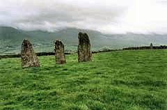
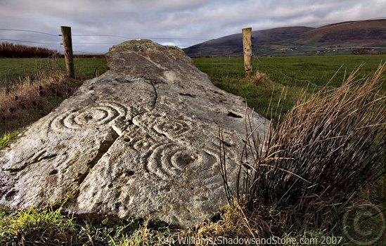
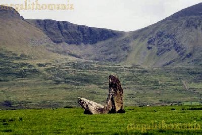
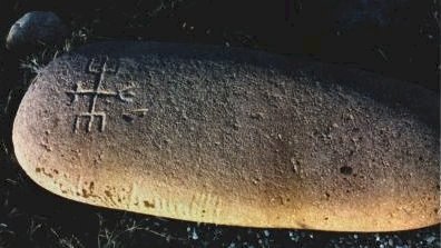
 photo by Jim Dempsey
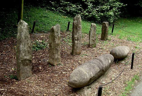