
county list
![]()
|
Turn smartphone to horizontal view.
Place-names in italics refer to listed entries. Convert Irish Grid references to Latitude/Longitude |
|
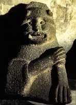
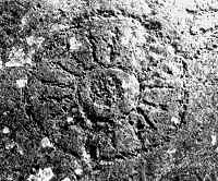
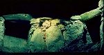
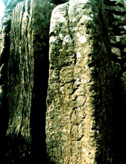
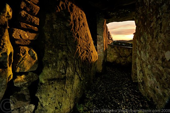
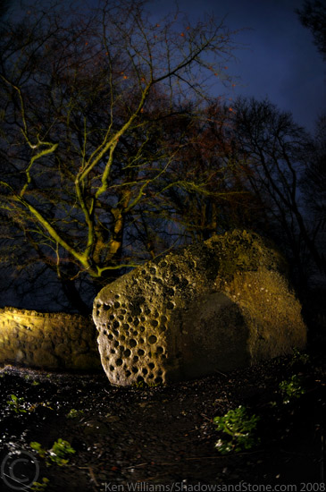
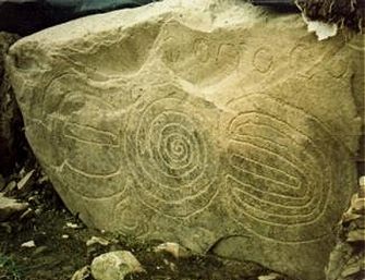
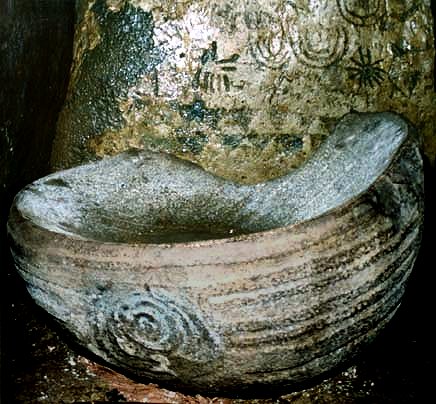
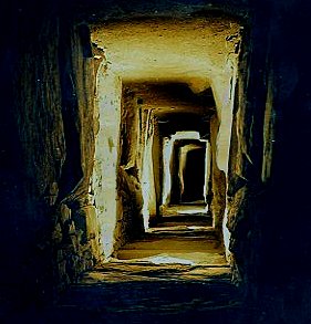
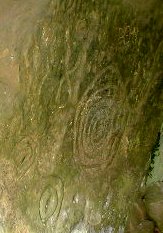
Of the three principal tombs of the Bend-of-the-Boyne passage-tomb necropolis or prehistoric palace of culture and science, this is the earliest and the only one (so far) not to be ransacked, vandalised and travestied by modern archæologists. It was partly excavated in 1847 though it had been pillaged (by Vikings and earlier looters) long before that. The cairn or tumulus is about 90 metres in diameter and 15 metres high. Three stone-lined passages lead into the mound from the W : one to a cruciform passage-tomb chamber, one to a circular passage-tomb chamber, and the third to a much later souterrain or refuge. Hitherto, the cruciform tomb was reached by climbing down a ladder in an iron cage, and crawling about over loose stones. Now, access is somewhat restricted, and all the features are guarded by metal grilles. The long passage is crossed by 3 sill-stones. This tomb is - in all senses - less developed than the neighbouring and preceding tourist-attractions of Newgrange and Knowth, partly because the chamber is much lower, and partly because the decoration is much poorer. The chamber is lintelled rather than corbelled, and on the floor stands a single stone basin - somewhat the worse for wear after 5,000 years. The right-hand arm of the chamber leads into another long rectangular chamber with 2 subsidiaries: an L-shaped extension entered over a low sill. This may be the earliest part of the tomb, later brought within the design of the cruciform tomb. It is floored with a 2.4 metre long flagstone containing an oval bullaun (artificial depression). Several of the orthostats of passage and chamber are decorated with spirals, chevrons, lozenges and rayed circles. Rayed circles or suns can also be seen click
for a larger, hi-res picture on one of the decorated kerbstones of the tumulus. A kerbstone with cup-marks, a spiral and a flower-like design marks the entrance to the second, smaller tomb - with modern concrete roof. quartz was found fallen outside the kerbing, showing that the entrance to this tomb was surrounding by glittering white, as at Newgrange. This tomb has a few decorated stones, and a single, massive right-hand recess. At the entrance to the passage of the cruciform tomb is an early mediæval souterrain. Pictures of sunset
rays penetrating the tomb at the Winter Solstice, 2006 can be
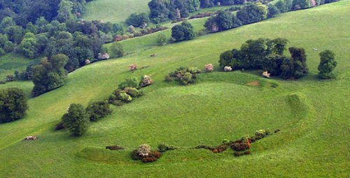
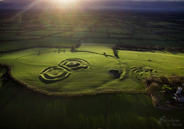
seen at ~ Nearby is a fine henge - here photographed for www.knowth.com - and probably best seen from the air.
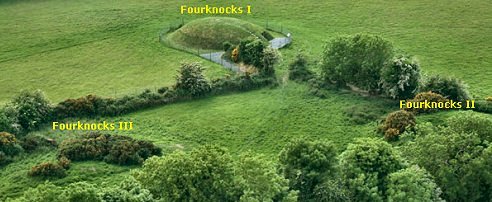
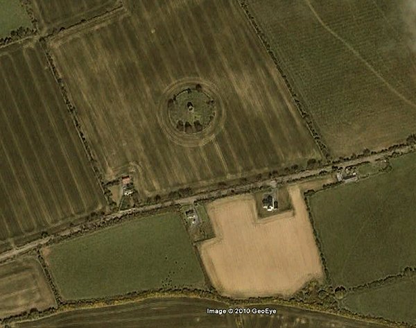
Fourknocks:
Passage-tomb 3.2 km WNW of the village
of (The) Naul, along a short track leading from a by-road, a
notice is displayed stating where the key can be obtained for
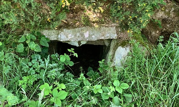
a deposit. A fine cruciform tomb, excavated, and now preserved
under a concrete shell dome grassed over, is imaginatively lit
by slits above the decorated lintels of the three recesses.
It is quite in contrast to the Disneyfication that has occurred
at Newgrange. The original tomb was probably roofed with timber
and sods. There are 12 fine decorated stones: one upright one
has a stylised human face. click
on the thumbnail for larger pictures
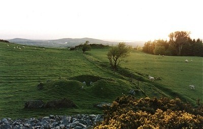
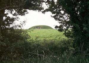
~ Just over 1 km NNW is a fine tree-ringed tumulus which is much like the Fourknocks tomb before it was excavated, and 1.6 km NNW is a henge-monument, also intact. A short distance to the E and close to the N side of the road is another fine tumulus, somewhat overgrown, but with many of its kerbstones surviving.
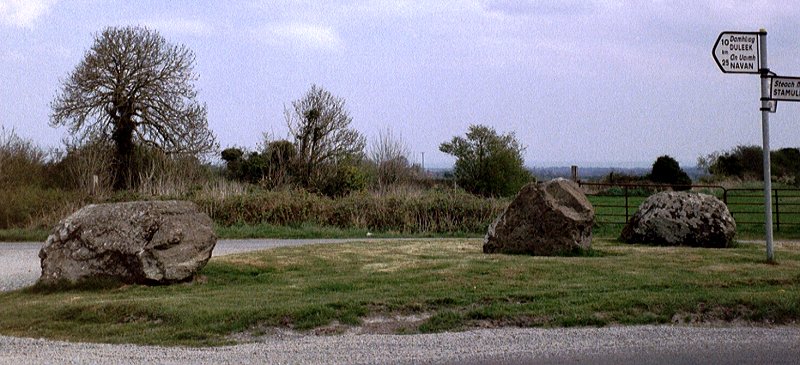
~ 2.3 km N by E are the remnants of a stone circle or cairn-kerb in Greenanstown (O 102 643): three large boulders sitting on a sward at a road-junction, in front of a bungalow. Behind the bungalow is another large boulder (of conglomerate) which could well come from the same circle or kerb. The names 'Greenan' and 'Green' (from Irish Grían meaning 'sun') are often associated with megaliths of one kind or another. ~ 7 km W in Hawkinstown, close to a road-junction (O 040 630) is an ogam-stone which has been moved from somewhere nearby. As well as the remains of an ogam-inscription near the base are other horizontal and diagonal grooves allegedly made by the uncle of the present (2003) landowner - who referred to the stone as "worthless"! It is not unusual for such stones to be used for knife-sharpening, whether out of a misplaced sense of ritual or out of the same malice which destroyed many thousands of megaliths, especially in the 20th century. ~ 6.5 km NE are the
remains of Knocknagin Passage-tomb (O 179 665) - a low
mound over 20 metres in diameter with several surrounding kerb-stones
protruding from the soil. It is quite separate from a nearby
group of tombs on the other (S) side of the Delvin River - see
under Bremore in county Dublin.
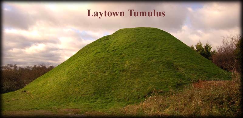
~ 5 km ESE of Fourknocks are the mounds at Knockbrack - see under Bremore in county Dublin. ~ 10 km NNE of Fournocks, between the R 150 and the river Nanny, less than 1 km WSW of Laytown, is a fine tumulus over 6 metres high and 25 metres in diameter. A late Iron Age burial mound it illustrates the longevity of tumuli in Ireland. ~ 16.5 km NNE of Fourknocks, at Baltray (O 144 782) across the Boyne in county Louth, W of a track leading N out of the hamlet of Baltray close to a strange concrete structure, are two standing-stones, over 2 metres high, which, it has recently been revealed, align significantly with the Fourknocks tomb in county Meath. Formerly there were three, but the absent monolith has not prevented the discovery that the larger of the two stones aligns with the offshore island of Rockabill towards sunrise at the Winter Solstice. There are also alignments to sunset at Summer Solstice and moonrise at Winter Solstice. Killary:
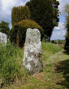
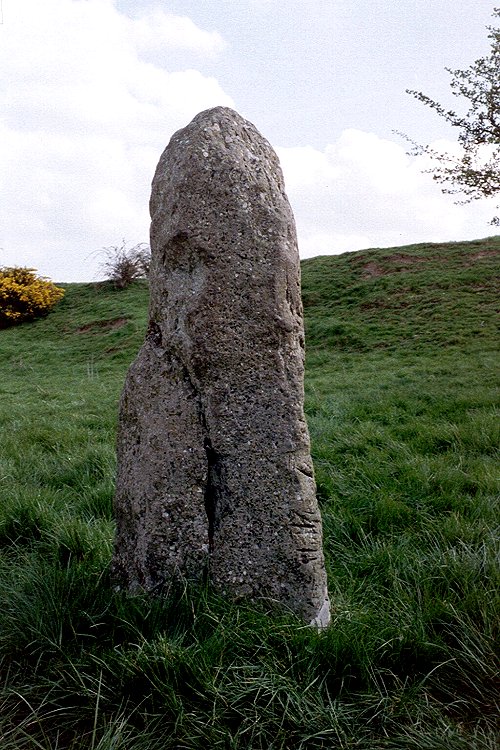
Standing-stone If this little standing-stone were anywhere else, it would not be worth mentioning. But because it is on a path in a pleasant graveyard where there is also the shaft of an Irish Romanesque sculpted cross (with scenes of Adam & Eve, the Sacrifice of Isaac, Noah's Ark and Daniel with the Lions), it is worth remarking on - even though it is only one metre high. Standing-stones occur in scores of ancient graveyards, including Killadeas and Dreenan in Fermanagh. Sometimes they have been Christianised, as at several sites in the Dingle Peninsula of Kerry.
Knowth: Passage-tomb - see under Newgrange, below. Loughcrew:
Passage-tomb complex Occupying
the two Loughcrew Hills of Carnbane East and Carnbane West in
Slieve na Calliagh (Sliabh na Caillighe), with car-parks
at the saddle between the hills, are several passage-tombs,
some of which are usually locked: see notices for where keys
may be obtained. There were originally between 50 and 100
cairns or tumuli in this prominently-sited necropolis, but the
usual Western European destruction and neglect of prehistoric
monuments (from earliest times) has greatly reduced the number.
Those which are locked have fine decoration, as well as one
or two small, unroofed tombs. Carnbane East is the hill
also known as Sliabh na Callighe, or the Hag's Mountain:
the tumuli were said to have dropped from the Hag/Earth
Mother's apron. [For
the folklore and excellent photos see the
Voices
from the Dawn website.] click
on the thumbnail for a larger picture is also
surrounded by 6 satellites with a variety of decoration in them,
including solar designs.
click
on the thumbnail for larger pictures surrounded by 7 smaller roofless tombs, some with decoration, and some with their short passages (mostly facing E) still partly roofed.
A sunny early-morning summer visit is recommended to see the engravings well.
These
tombs represent an intermediate stage in the development of
elaborate tombs between the skyline cairns of Carrowkeel
in Sligo, and the lowland complexes in the E of county Meath.
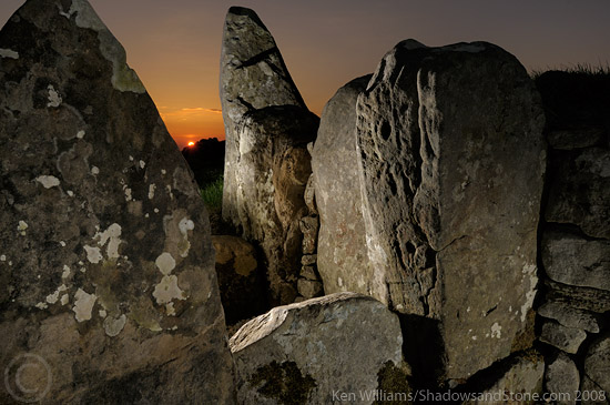
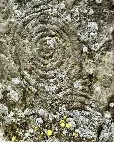
~ About 700 metres to the E of Carnbane East, on Patrickstown Hill, are the less-accessible remains of 4 more tombs, out of a former 25 or so. ~ On King's Mountain, 3.2 km to the E, a decorated lintel now stands upright on the site of a destroyed tomb. Half of one face is covered with well-executed spirals (the largest being over 40 cms in diameter) and arcs. click
for a superb photo by Ken Williams ~ 800
metres E of Carnbane East, 300 metres W of a by-road and up
a muddy farm-track in Ballinvally (N 581 786) are the
remains of a stone circle, some 25 metres in diameter, in which
four large stones up to 2 are very obvious. It is visible from
the cairns on Carnbane E and W - and vice versa. A ruined wall
cuts across its eastern side, separating one of the seven or
so surviving uprights from the others, one of which is massive,
and another of which has beautiful natural fissures in it. Five
or six stones extend in a row N of the circle for a distance
of 800 metres, and there are several small isolated standing-stones
scattered about the surrounding area. For a more detailed description
of this very disturbed site, click
here. ~ About 4 km SE of Slieve na Calliagh, in the graveyard of Bobsville (N 616 744) is a large upright stone bearing many cupmarks and a wedge-shaped depression. The graves of the burial-ground are all set into a rather large mound, 3-4 metres high and about 40 metres in diameter: possibly a passage-tomb that the cupmarked stone came from or was set up on. Set into the wall by the gate there are some 'Clonmacnoise-style' decorated cross-slabs of the ?11th century, and a Tau or T-cross.
Mullagharoy: Decorated Stone - see under Hurlstone, county Louth Newgrange:
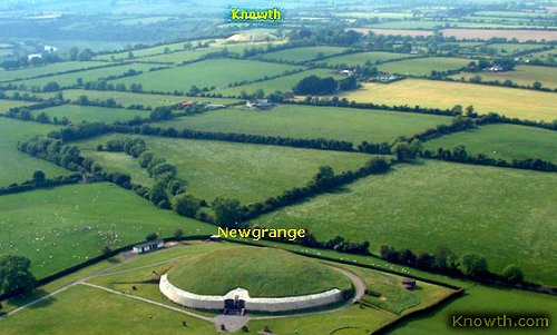
Passage-tomb and Stone circle Open daily, with guided tours in summer, this remarkable tomb has been degraded by "restoration" and by its status as one of Ireland's top three tourist attractions and the only prehistoric tomb that most visitors to - and natives of - Ireland can be bothered to see. Under the pressure of coachloads, the casually curious, and the faintly-inquisitive, not to mention the fatuously over-restored façade, it has lost all its atmosphere. Thus it is, perhaps, in a worse situation than Stonehenge. Books and photographs "explaining" it can be bought on-site - which might more fittingly be a shrine to Padre Pio than to archæology. It is hard to appreciate the fine circle surrounding the mound of Newgrange, because of the razmatazz of the pseudo-authentic entrance to the tomb, the visitor centre, the guides, the buses, the ticket-booth and all those things that cheapen the place for the brief bemusement of gawpers who mostly know little about Ireland and less about prehistoric Europe - and go away knowing very little more. The circle was erected after the tomb was built, apparently by late-Neolithic "Beaker-people" from Northern Britain, who also built a smaller circle at Ballynoe in county Down. Twelve out of an original 35 large stones survive. click
the thumbnail for larger pictures The reason for the building of the circle was perhaps to incorporate it into a new form of sanctity, just as old churches in Ireland were taken over from the Celtic rite first by the Roman orthodoxy, then later by the Anglicans. Or possibly to restore it to an ancient form of sanctity as a reaction against the development of the Boyne Valley monuments into cathedrals of science. There are also satellite-tombs, many of which have also been excavated.
~ Slightly over 1 km NW of Newgrange is the even more complex, marvellous and even more pillaged tomb of Knowth, with several decorated stones outside and inside the tombs, and also with satellite tombs. It is has been sold to mass-tourism in the same way as Newgrange, and included in the same "Customer Package" - and if there are disquieting reports of the manufacturing and/or altering and/or suppressing of archæological evidence to bolster comfortable hypotheses, there is a strong tradition of such practices in Irish archæology.
By the time the passage-tomb-building societies had extended their activities and influence from Sligo, via the skyline-necropolises of Carrowkeel and Loughcrew, as far as the Bend of the Boyne - where (apart from the absence of dominating heights) the land and landscape resembled the Sacred Plateau of Carrowmore and environs - they had become obsessed, like the Babylonians whose systems we still use, with astronomy and astrology, and obviously were a plutocratic, totalitarian hierocracy.
See Google Earth photos of Boyne Valley Tombs. > View a slide-show of the interior of the main tomb at KNOWTH. Rathkenny: Portal-tomb, see under Hurlstone, county Louth Tara
(Castleboy
townland):
Passage-tomb and phallic
pillar
The Lía Fáil was moved from its position as significant standing-stone near the second most interesting thing: 'The Mound of the Hostages', which is in fact a small passage-less passage-tomb, whose entrance is covered with a grille.
Its walls are composed of just 7 massive orthostats, one of which is decorated, and only half of the chamber is roofed: with 2 massive capstones. One of the great celebrations traditionally associated with Tara was the week-long festival of Samhain (1st November, the 'Gap of the Year', when the veil between the natural and the supernatural can easily be rent) - and when the rising sun illuminates - through the grille - the back of the 'Mound of the Hostages'. A recent theory suggests that the decorated stone in the 'Mound of the Hostages' is in fact a plan of the Hill of Tara. Read the (poorly-written) PDF document. "The British Israelites", who, early in the 20th century took spades to the site and dug unsuccessfully for the Ark of the Covenant, have an interesting opinion on the Lía Fáil: The phallic Baal-pillar stone that is now wrongfully
and blasphemously called the Lía Fáil,
was re-discovered and placed on The Inauguration Mound at Tara
some time between 1839 and 1845.
More recently, however, motorway construction has threatened it. see also an excellent online history of Tara and its many other structures up to the present: https://voicesfromthedawn.com/tara/ |